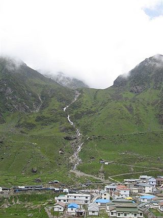
Kedarnath is a town and Nagar Panchayat in Rudraprayag district of Uttarakhand, India, known primarily for the Kedarnath Temple. It is approximately 86.5 kilometres from Rudraprayag, the district headquarter. Kedarnath is the most remote of the four Chota Char Dham pilgrimage sites. It is located in the Himalayas, about 3,583 m (11,755 ft) above sea level near the Chorabari Glacier, which is the source of the Mandakini river. The town is flanked by snow-capped peaks, most prominently the Kedarnath Mountain. The nearest road head is at Gaurikund about 16 km away. The town suffered extensive destruction during June 2013 from the Flash Floods caused by torrential rains in Uttarakhand state.

The Alaknanda is a turbulent Himalayan river in the Indian state of Uttarakhand and one of the two headstreams of the Ganges, the major river of Northern India and a river considered holy in Hinduism. In hydrology, the Alaknanda is considered the source stream of the Ganges on account of its greater length and discharge; while, in Hindu tradition and culture, the other headstream, the Bhagirathi, is considered the source stream.

Devprayag is a town and a nagar panchayat, near New Tehri city in Tehri Garhwal District in the state of Uttarakhand, India, and is the final one of the Panch Prayag of Alaknanda River where Alaknanda meets the Bhagirathi river and both rivers thereafter flow on as the Ganges river or Ganga.

Rudraprayag is a district of the state of Uttarakhand of northern India. The district occupies an area of 1984 km2. The town of Rudraprayag is the administrative headquarters of the district. The district is bounded by Uttarkashi District on the north, Chamoli District on the east, Pauri Garhwal District on the south, and Tehri Garhwal District on the west.

Triyuginarayan Temple is a Hindu temple located in the Triyuginarayan village in Rudraprayag district, Uttarakhand, India. The ancient temple is dedicated to god Vishnu. Its fame is credited to the legend of god Shiva’s marriage to goddess Parvati witnessed by Vishnu at this venue and is thus a popular Hindu pilgrimage sites. A special feature of this temple is a perpetual fire, that burns in front of the temple. The flame is believed to burn from the times of the divine marriage. Thus, the temple is also known as Akhand Dhuni temple.

Rudraprayag is a city and a municipality in Rudraprayag district in the Indian state of Uttarakhand. Rudraprayag is one of the Panch Prayag of Alaknanda River, the point of confluence of rivers Alaknanda and Mandakini. Kedarnath, a Hindu holy city is located 86 km from Rudraprayag. The man-eating Leopard of Rudraprayag hunted and written about by Jim Corbett dwelled here.

The Mandakini River is a tributary of the Alaknanda River in the Indian state of Uttarakhand. The river runs for approximately 81 kilometres (50 mi) between the Rudraprayag and Sonprayag areas and emerges from the Chorabari Glacier. The Mandakini merges with river Songanga at Sonprayag and flows past the Hindu temple Madhyamaheshwar at Ukhimath. At the end of its course it drains into the Alaknanda, which flows into the Ganges.

The Garhwali people are an Indian ethnolinguistic group native to the Garhwal, in the Indian state of Uttarakhand, who speak Garhwali, an Indo-Aryan language.
Augustmuni is a town on the banks of the Mandakini River in Rudraprayag district, Uttarakhand, India. It is located 16 kilometers from the city of Rudraprayag, and is named after the Hindu/Yogic Siddhar Agastya, one of the original seven rishis or Saptarishis.
Kedarnath Wild Life Sanctuary, also called the Kedarnath Musk Deer Sanctuary, is a wildlife sanctuary declared under Wildlife Protection Act, 1972 and located in Uttarakhand, India. Its alternate name comes from its primary purpose of protecting the endangered Himalayan musk deer. Consisting of an area of 975 km2 (376 sq mi), it is the largest protected area in the western Himalayas.It is famous for alpine musk deer, Himalayan Thar, Himalayan Griffon, Himalayan Black bear, Snow Leopard and other flora park and fauna. It is internationally important for the diversity of its flora and fauna.

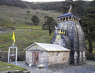
Panch Kedar, rendered Pancha Kedara in Sanskrit, refers to five Hindu temples or holy places of the Shaivite sect dedicated to god Shiva. They are located in the Garhwal Himalayan region in Uttarakhand, India. They are the subject of many legends that directly link their creation to Pandavas, the heroes of the Indian epic Mahabharata.
Madhyamaheshwar or Madmaheshwar is a Hindu temple dedicated to Shiva, located in Gaundar, a village in the Garhwal Himalayas of Uttarakhand, India. Situated at an elevation of 3,497 m (11,473.1 ft), it is one of the Panch Kedar pilgrimage circuits, comprising five Shiva temples in the Garhwal region. The other temples in the circuit include: Kedarnath, Tungnath and Rudranath which are culturally visited before Madhyamaheshwar and, Kalpeshwar generally visited after Madhyamaheshwar. The middle (madhya) or belly part or navel (nabhi) of Shiva is worshipped here. The temple is believed to have been built by the Pandavas, the central figures of the Hindu epic Mahabharata.

Panch Prayag is an expression in Hindu religious ethos, specifically used to connote the five sacred river confluences in the Garhwal Himalayas in the state of Uttarakhand, India. The five prayags - prayaga meaning "place of confluence of rivers" in Sanskrit - also termed as "Prayag pentad" are Vishnuprayag, Nandaprayag, Karnaprayag, Rudraprayag and Devprayag, in the descending flow sequence of their occurrence.
Guptakashi, Gupta Kashi or Guptkashi is a fairly large town located at an elevation of 1,319 metres (4,327 ft) in the Kedar-khanda, in Garhwal Himalayas of Rudraprayag district in Uttarakhand, India. It is known for its ancient Vishwanath Temple dedicated to the god Shiva, which is similar to the one in Varanasi (Kashi). The other well known temple here is dedicated to Ardhanareshvara, a half man half woman form of Shiva and Parvati. The name Guptakashi has legendary significance linked to the Pandavas, the heroes of the Hindu epic Mahabharata. Its religious importance is considered next to that of Varanasi, believed to be the most pious of all Hindu pilgrimage sites.

Ukhimath is a small town and a Hindu pilgrimage site in Rudraprayag district, Uttarakhand in India. It is situated at an elevation of 1,311 meters and at a distance of 41 km from Rudraprayag. During the winter, the Utsava Idols from the Kedarnath Temple, and Madhyamaheshwar Temple are brought to Ukhimath and worshipped here for six months. Ukhimath can be used as center destination for visiting different places located nearby, the Madhyamaheshwar Temple, Tungnath Temple and Deoria Tal and many other picturesque places. According to Hindu Mythology, the wedding of Usha and Aniruddha was solemnized here. By name of Usha this place was named as Ushamath, now known as Ukhimath. King Mandhata had performed severe penances to Lord Shiva here. During the winter, the Kedarnath and Madhyamaheshwar Temples are closed due to heavy snowfall in the area. As a result, the Utsava Idols of Kedarnath and Madhyamaheshwar are brought from Kedarnath and Madhyamaheshwar to the Omkareshwar Temple in Ukhimath. The winter puja of Kedarnath and Omkareshwar is performed here. The Omkareshwar Temple is located at Ukhimath, which is at a distance of 41 km from Rudraprayag.
Ghansali is located in Ghansali Tehsil of Tehri Garhwal district in Uttarakhand, India. Ghansali town offers a splendid beauty of Bhilangana River on one side and dense forest at other. According to the 2011 census it has a population of 392 living in 82 households. Its main agriculture product is paddy growing.
Uttarakhand is a state in the northern part of India. It is often referred to as the "Devbhoomi" due to its religious significance and numerous Hindu temples and pilgrimage sites found throughout the state. As a result, religious tourism forms a major portion of the tourism in the state. Uttarakhand is known for the natural environment of the Himalayas. 2019 Tourist Arrivals Domestic – 40,000,000 per/year and Foreigner – 150,000 per year. Tourism business in Uttarakhand generated ₹ 23,000 crores during 2013–14.

Operation Surya Hope was the Indian Army’s Central Command response to the June 2013 North India floods in Uttarakhand.

Char Dham National Highway, is an under construction two-lane 889 km long National Highway with a minimum width of 10 metres in the Indian state of Uttarakhand under Char Dham Pariyojana. The under construction highway will complement the under-construction Char Dham Railway by connecting the four holy places in Uttarakhand states namely Badrinath, Kedarnath, Gangotri and Yamunotri. The project includes 889 km national highways which will connect the whole of Uttarakhand state. It will connect Delhi–Dehradun Expressway on its southern end to India-China Border Roads on its northern ends.
Sonprayag is a village in the Rudraprayag district of Uttarakhand state in India. Approximately 73 Kilometres from Rudraprayag Town, the district headquarter. Situated on the banks of river Mandakini River, it is a proposed Y-forked railway junction on Chota Char Dham Railway for two different railways going to Kedarnath and Badrinath.