Uttar Pradesh is a state in northern India. With over 241 million inhabitants, it is the most populated state in India as well as the most populous country subdivision in the world – more populous than all but three other countries outside of India. – accounting for 16.5 per cent of the total population of India. It was established in 1950 after India had become a republic. It is a successor to the United Provinces, established in 1935 by renaming the United Provinces of Agra and Oudh, in turn established in 1902 from the North-Western Provinces and the Oudh Province. Lucknow serves as the state capital, with Prayagraj being the judicial capital.

The Yamuna is the second-largest tributary river of the Ganges by discharge and the longest tributary in India. Originating from the Yamunotri Glacier at a height of about 4,500 m (14,800 ft) on the southwestern slopes of Bandarpunch peaks of the Lower Himalaya in Uttarakhand, it travels a total length of 1,376 kilometres (855 mi) and has a drainage system of 366,223 square kilometres (141,399 sq mi), 40.2% of the entire Ganges Basin. It merges with the Ganges at Triveni Sangam, Prayagraj, which is a site of the Kumbh Mela, a Hindu festival held every 12 years.

India is a federal union comprising 28 states and 8 union territories, with a total of 36 entities. The states and union territories are further subdivided into districts and smaller administrative divisions.

The United Provinces of Agra and Oudh was a province of India under the British Raj, which existed from 1902 to 1937; the official name was shortened by the Government of India Act 1935 to United Provinces (UP), by which the province had been commonly known, and by which name it was also a province of independent India until 1950.
Muzaffarnagar is a city under Muzaffarnagar district in the Indian State of Uttar Pradesh. It is situated midway on the Delhi - Haridwar/Dehradun National Highway and is also well connected with the national railway network. It is known as the sugarbowl of Uttar Pradesh.

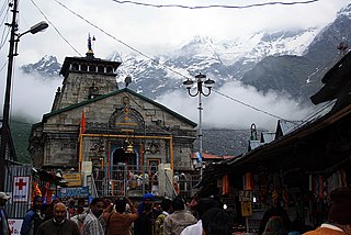
Uttarakhand, also known as Uttaranchal, is a state in northern India. It is often referred to as the "Devbhumi" due to its religious significance and numerous Hindu temples and pilgrimage centres found throughout the state. Uttarakhand is known for the natural environment of the Himalayas, the Bhabar and the Terai regions. It borders the Tibet Autonomous Region of China to the north; the Sudurpashchim Province of Nepal to the east; the Indian states of Uttar Pradesh to the south and Himachal Pradesh to the west and north-west. The state is divided into two divisions, Garhwal and Kumaon, with a total of 13 districts. The winter capital of Uttarakhand is Dehradun, the largest city of the state, which is a rail head. Gairsain, a town in Chamoli district, is the summer capital of Uttarakhand declared on 5 March 2020. The High Court of the state is located in Nainital, but is to be moved to Haldwani in future.

Yamunanagar, is a city and a municipal corporation in Yamunanagar district in the Indian state of Haryana. This town is known for the cluster of plywood units and paper factories. It provides timber to larger industries. The older town is called Jagadhri. The Yamunanagar-Jagadhri railway station (YJUD) services the city. Despite its name, Jagadhri Railway is situated in Yamunanagar. There is also another railway station called Jagadhri Workshop in Yamunanagar.

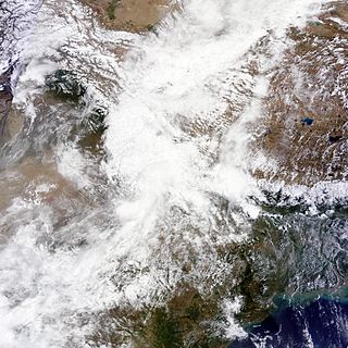
North India, also called Northern India or simply the North, in a broader geographic context, typically refers to the northern part of India or historically, of the Indian subcontinent, occupying 72.6% of India's total land area and 75% of India's population, and where Indo-Aryans form a prominent majority population. The region has a varied geography ranging from the Indo-Gangetic Plain and the Himalayas, to the Thar Desert, the Central Highlands and the north-western part of the Deccan plateau. Multiple rivers flow through this region including the Ganges, the Yamuna, the Indus and the Narmada rivers. In a more specific and sometimes administrative sense, North India can also be used to denote a smaller region within this broader expanse, stretching from the Ganga-Yamuna Doab to the Thar Desert.

Roorkee (Rūṛkī) is a city and a municipal corporation in the Haridwar district of the state of Uttarakhand, India. It is 31 km (19 mi) from Haridwar city, the district headquarter. It is spread over a flat terrain under Sivalik Hills of Himalayas. The city is developed on the banks of Ganges Canal, its dominant feature, which flows from north–south through middle of the city. Roorkee is home to Asia's first engineering college Indian Institute of Technology Roorkee, formerly known as Thomson College of Civil Engineering. Roorkee is also known for the Roorkee Cantonment, one of the country's oldest military establishments and the headquarters of Bengal Engineer Group since 1853. A freight train ran in between Roorkee and Piran Kaliyar on 22 December 1851, this was two years before first passenger trains were started between Bombay and Thana in 1853 and 14 years after first freight trains ran in Chennai in 1837.

Allahabad High Court, officially known as High Court of Judicature at Allahabad is the high court based in the city of Prayagraj, formerly known as Allahabad, that has jurisdiction over the Indian state of Uttar Pradesh. It was established on 17 March 1866, making it one of the oldest high courts to be established in India.
The United Provinces (UP) was a province of British India and, subsequently, independent India.
Sadabad is a town and a nagar panchayat in Hathras district in the Indian state of Uttar Pradesh.

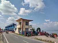
Tanakpur is a city and a municipal board in Champawat district of Uttarakhand state of India. Located in the plains area in the northern part of India. The town is the gateway for Purnagiri Temple as well as the 'Gateway to the Kumaon Himalayas'.
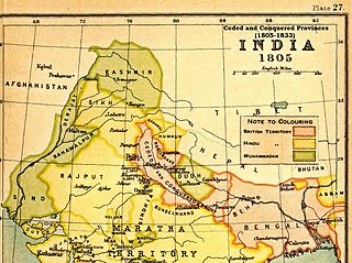
The Ceded and Conquered Provinces constituted a region in northern India that was ruled by the British East India Company from 1805 to 1834; it corresponded approximately—in present-day India—to all regions in Uttar Pradesh state with the exception of the Lucknow and Faizabad divisions of Awadh; in addition, it included the Delhi territory and, after 1816, the Kumaun division and a large part of the Garhwal division of present-day Uttarakhand state. In 1836, the region became the North-Western Provinces, and in 1904, the Agra Province within the United Provinces of Agra and Oudh.

The Sharda River, also called Kali River and Mahakali River, originates at Kalapani in the Himalayas at an elevation of 3,600 m (11,800 ft) in the Pithoragarh district in Uttarakhand, India. It flows along Nepal's western border with India and has a basin area of 14,871 km2 (5,742 sq mi). It joins Ghaghra River, a tributary of the Ganges. It takes the name Kali River from the union of the two streams at Gunji as it flows through the hills. After Brahmadev Mandi near Tanakpur, it enters the Terai plains, where it is called Sharda River.
The Hurkiya are a caste found in the states of Uttar Pradesh and Uttarakhand in India. They have been granted Scheduled Caste status in both these states. In fact, there are two distinct communities that go by the name Hurkiya, those of Uttarakhand, who are Hindu by religion, and those found in western Uttar Pradesh, who are Muslim. Both Hurkiya are of common origin, being a sub-group within the Dom ethnic group, and are one of the many gypsy like grouping found in North India.
In June 2013, a mid-day cloudburst centered on the North Indian state of Uttarakhand caused devastating floods and landslides, becoming the country's worst natural disaster since the 2004 tsunami. The rainfall received that month was far greater than the rainfall the state usually received. Debris blocked the rivers, causing major overflow. The main day of the flood was 16 June 2013.

The history of Uttar Pradesh, a state in India, stretches back several millennia. The region shows the presence of human habitation dating back to between 85,000 and 73,000 years ago. Additionally, the region seems to have been domesticated as early as 6,000 BC.