Nainital Lake

Last updated

Nainital Lake, Nainital
The Boat and The Lake.jpg
Scenic view of Nainital from Tallital
India Uttarakhand relief map.svg
Red pog.svg
Nainital Lake, Nainital
Location in Uttarakhand
India relief location map.jpg
Red pog.svg
Nainital Lake, Nainital
Nainital Lake, Nainital (India)
Location Nainital Town, Kumaon, India
Coordinates 29°23′15″N79°27′27″E / 29.38750°N 79.45750°E / 29.38750; 79.45750
Type Natural Freshwater Body
Basin  countriesFlag of India.svg  India
Max. length1,432 m (4,698 ft)
Max. width457 m (1,499 ft)
Surface area48.76 ha (120.5 acres)
Max. depth30.3 m (99 ft)
Residence time 1.16 years
Surface elevation1,938 m (6,358 ft)
Settlements Nainital Town
Nainital Lake

Naini Tal, also known as Naini Lake, is a natural freshwater body, situated amidst the town of Nainital in Kumaon, Uttarakhand, India. It is tectonic in origin and was almost circular,until frequent landslides made it crescent shaped and has an outfall at the southeastern end. [1] [2] Nainital, along with other lakes of Kumaon, is integral to tourism and recreation in Kumaon. The lake is also an integral part of Kumaoni folklore.

Contents

Nainital Lake in Nainital Town of the Nainital district, often called the Lake District of India, is one of the four important lakes of Kumaon; the other three are Sattal Lake, Bhimtal Lake and Naukuchiyatal Lake. [3] It's the 3rd biggest lake by surface area in Uttarakhand.

A Kumaoni man on the Lake in Nainital Boat-Man at Naini Lake.jpg
A Kumaoni man on the Lake in Nainital

History

A view of the south end of the lake, 1866 Nainital Lake 1866.jpg
A view of the south end of the lake, 1866

Historical records confirm that in 1839, Mr. P. Barron, who is supposed to be the first one who visited Nainital. He was an English business man in sugar trade, on an expedition accidentally coming across the lake at Nainital was so captivated that he decided to build a European Colony on shores of the lake. The news magazine, the Englishman Calcutta, reported in 1841 discovery of this lake near Almora. [4]

Topography and Hydrology

The lake is bounded by the high and steep Naina peak on the North West side, by the Tiffin Top to the south west side and snow view peaks on the north. Coniferous forest trees cover these hill ranges. The annual rainfall in the basin area of the lake is reported to be 1,294.5 mm (50.96 in). Tropical monsoon climate with maximum temperature 24.6 °C and minimum of 0.5 °C are recorded. The water is reported to be alkaline in nature (ph value of 8.4–9.3). [2]

The lake receives flows from the surrounding catchment basin which comprises the hill slopes and springs. The hydrologic studies related to water balance and sedimentation was done using radioisotopes for estimating/measuring the various components of the inflow and outflow into the lake. Studies indicated that the subsurface inflow and outflow were significant – ranging from 43 to 63% and 41 to 54%, respectively, of the total inflow and outflow, except in years of exceptionally heavy rainfall. The components of outflows were the surface outflow, the subsurface outflow through the springs on the downstream side and draft through wells for meeting the water supply of Nainital town and evaporation loss from the lake surface. The mean water retention time for the lake was computed as 1.16 years for the mean annual rainfall. [1]

Geology

The Krol group of rocks, comprising slates, marls, sandstones, limestones and dolomites with a few small dykes intrusives, is the dominant geological formation of the lake's surroundings. The lake is deduced to have been formed tectonically. Balia Nala, which is the main stream feeding the lake is along a fault line and the subsequent streams align parallel to major joints and faults. 26 major drains feed the lake including the 3 perennial drains. The lake catchment has highly folded and faulted rocks due to poly phase deformation. Landslides are a frequent occurrence in the hill slopes surrounding the lake, which are steep. The slopes are highly vulnerable to landslides and mass movement due to various geological and human factors. Several landslides have occurred in the past (pictured) around the lake. Many settlements around the lake are located in landslide areas. [1]

Flora and fauna

While the Nainital district where the lake is situated (in the middle Himalayan ranges up to 2,000 m (6,600 ft), a temperate zone), is rich in flora (typical temperate climate plants) and fauna, the details of the flora and fauna specific to the lake and its surroundings recorded are the following. [5]

Vegetation

The trees and bushes grown in the region (lake's basin) with their botanical and common Indian names (in parentheses) are reported to be: a) Quercus leucotrichophora Oak (Banj); b) Aesculus indica (Pangar or Horse chestnuts); c) Juglans regia (Akhrot or walnut), d) Populus ciliata (Hill Pipal, a sacred tree); e) Fraxinus micrantha (Ash tree or Angu); f) Platanus orientalis (Chinar); g) Rubus lasiocarpus (Hisalu); h) Rosa moschata (Kunj or Musk rose); i) Berberis asiatica (Kilmora);j) Cupressus torulosa (Surai or Himalayan cypress); k) Rhododendron arboreum (Buruns); Cedrus deodara (Deodar); l) Salix acmophylla (Weeping Willow); and m) Pinus (Pine). [5]

The Aquatic Macrophytic vegetation recorded are the a) Potamogeton pectinatus , 2) Potamogeton crispus, 3) Polygonum glabrum, 4) Polygonum amphibium and Polygonum hydropiper (Water pepper). [5]

Several species of medicinal flora and horticulture plants have also been reported.

Aqua fauna

Hill trout found abundant in Nainital Lake Hill trouts in Nainital Lake.jpg
Hill trout found abundant in Nainital Lake

The fishes found in the lake are generally carps: species of mahseer, [lower-alpha 1] hill trout, and the mirror carp which breed several times during one spawning season during May to September. Two species of mahaseer fish are present: Tor tor , the red-finned mahseer, and Tor putitora the yellow-finned mahseer, a food fish which grows to varying sizes from 20 to 60 cm (8 to 23.5 in) are reported. The three species of hill trout found in the lake are Schizothorax sinuatus, S. richardsoni and S. plagiostornus. The imported fish bred in the lake is mirror carp, a variety of the common carp Cyprinus carpio . [5] The mosquitofish Gambusia affinis has been introduced in the lake for the biocontrol of mosquito larvae. [5]

Fauna

Nine species of birds and nine species of animals have been recorded in the Nainital district.

Water quality

A scientific study indicates that the open drains feeding the lake introduce toxic substances from the catchment of the lake, particularly heavy metals which get adsorbed onto the suspended sediments, which in turn settle down in the bottom of the lake. A study of the risk assessment code has revealed that 4–13% of manganese, 4–8% of copper, 17–24% of nickel, 3–5% of chromium, 13–26% of lead, 14–23% of cadmium and 2–3% of zinc exist in exchangeable fraction which puts the lake under the low to medium risk category and infers that it could enter into food chain and also cause deleterious effects to aquatic life. This study provides the basic database to formulate guidelines for the dredging operations and/or restoration programmes in the lake. [6]

The water quality studies carried out by the National Institute of Hydrology during 1999–2001 on physico-chemical parameters (pH, temperature profile, Secchi's transparency, dissolved oxygen, BOD, COD and nutrients), biological profile (density of population, biomass and species diversity of phyto, zooplankton and macrobenthos) and bacteriological characteristics have led to the conclusion that long-term limnological changes have occurred in the lake. Excess of nutrients inflow have contributed to the eutrophic conditions and the internal recycling of nutrients from sediments during water circulation has resulted in luxurious growth of phytoplankton. The lake is thus anoxic and has reduced hypolimnion, winter circulation, large phytoplankton and relatively lower animal population. [1]

Threats to the lake

The problems facing the lake which were also listed in the plea in a Public Interest Litigation (PIL) before the Supreme Court of India in 1995 seeking court directive for redress measures could be summarised as below: [1]

Lake restoration

The National Institute of Hydrology (NIH) of Roorkee who prepared a plan for the restoration of the lake, at an estimated cost of Rs 50 crore (about US$10 million), sponsored by the Ministry of Environment and Forests, Government of India, are also now guiding the restoration measures. [8] The Conservation and Management Plan evolved by NIH is not only lake centric but also proposes to tackle the immediate periphery of the lake which contributes an adverse impact on the lake. The "Nainital Jheel Parikshetra Vishesh Kshetra Vikas Pradhikaran", the Lake Development Authority notified under U.P. Special Area Development Act 1986 is a Special Purpose Vehicle (SPV) set up for implementing the restoration works. [1] The restoration works that have been implemented or are in different stages of implementation are the following:

Landslide in 1880 Nainital landslip1880 BLcopyright2.JPG
Landslide in 1880

The Honourable Supreme Court of India in its judgment of 1995, in response to the Public Interest Litigation, gave the following recommendations which have also been addressed in the restoration measures mentioned above. [1] [7]

(i)Sewage water has to be prevented at any cost from entering the lake; (ii) So far as the drains which ultimately fall in the lake are concerned, it has to be seen that building materials are not allowed to be heaped on the drains to prevent siltation of the lake;(iii) Care has been taken to see that horse dung does not reach the lake. If for this purpose the horse stand has to be shifted somewhere, the same would be done. The authorities would examine whether trotting of horses around the lake is also required to be prevented;(iv) Multi-storeyed group housing and commercial complexes have to be banned in the town area of Naini Tal. Building of small residential houses on flat areas could, however, be permitted;(v) The offence of illegal felling of trees is required to be made cognizable.(vi) Vehicular traffic on the Mall has to be reduced. Heavy vehicles may not be permitted to ply on Mall;(vii) The fragile nature of Ballia Ravine has to be taken care of. The cracks in the revetment of Ballia Nullah have to be repaired urgently.

In the "India Today" magazine, Prasanta Rajan, a journalist, in a preamble to the particular interest shown by the Lady District Magistrate of Nainital in restoration works of the lake has very vividly described the lake in these words:

Look for the lake through the colonial windows of Pant House, a vintage English bungalow on the hilltop, now submerged in wintry night, solitary with a kind of Wuthering Heights mystery. Down below, the lake is a laminated stillness, protected by seven never-sleeping hills. In the dead darkness of Kumaon, this magnificence is a distant, partially lit vision, less than real, as the hills of frozen memories make the lake a footnote in water.

Other attractions

The Nainital Yacht Club, housed in the Boat House Club, offers yachting facilities at the lake, where a fleet of Half Raters, designed by Linton Hope, sails. [10] [11] The Annual Kingfisher Yachting Competition (Regatta) is held here in the third week of June. [12] The Kumaon festival which brings out the local cultures and traditions is organized every year during the winter months of October and November, by the Tourism Department. [12]

See also

Notes

  1. The Kumaoni term mahāsir, mahāser, or mahāsaulā is used for a number of fishes of the group.

Related Research Articles

<span class="mw-page-title-main">Utah Lake</span> Freshwater lake in Utah County, Utah, United States

Utah Lake is a shallow freshwater lake in the center of Utah County, Utah, United States. It lies in Utah Valley, surrounded by the Provo-Orem metropolitan area. The lake's only river outlet, the Jordan River, is a tributary of the Great Salt Lake. Evaporation accounts for 42% of the lake's outflow, which leaves the lake slightly saline. The elevation of the lake is at 4,489 feet (1,368 m) above sea level. If the lake's water level rises above that, the pumps and gates on the Jordan River are left open. Recently the lake has been at a lower level because of a drought.

<span class="mw-page-title-main">Nainital</span> Town in Uttarakhand, India

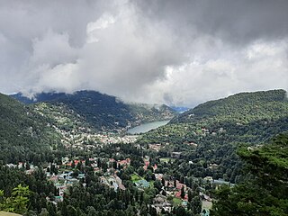
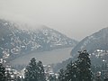
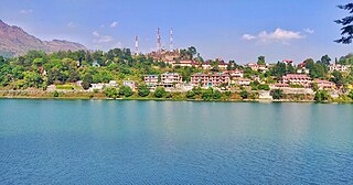
Nainital is a town and headquarters of Nainital district of Kumaon division, Uttarakhand, India. It is the judicial capital of Uttarakhand, the High Court of the state being located there and is the headquarters of an eponymous district. It also houses the Governor of Uttarakhand, who resides in the Raj Bhavan. Nainital was the summer capital of the United Provinces.

<span class="mw-page-title-main">Mahseer</span> Common name for several genera of carp

Mahseer is the common name used for the genera Tor, Neolissochilus, Naziritor and Parator in the family Cyprinidae (carps). The name is, however, more often restricted to members of the genus Tor. The range of these fish is from Vietnam in the east and China in the north, through Laos, Cambodia, Thailand, Malaysia, Brunei and Indonesia, and across southern Asia including the countries of India, Nepal, Bhutan and Bangladesh within the Indian Peninsula, plus Sri Lanka, Pakistan and Afghanistan. They are commercially important game fish, as well as highly esteemed food fish. Mahseer fetch high market price, and are potential candidate species for aquaculture. Several of the larger species have suffered severe declines, and are now considered threatened due to pollution, habitat loss, overfishing and increasing concern about the impacts of unregulated release of artificially bred stock of a very limited number of species.

<span class="mw-page-title-main">Kumaon division</span> Administrative division in India

Kumaon is a revenue and administrative division in the Indian State of Uttarakhand. It spans over the eastern half of the state and is bounded on the north by Tibet, on the east by Nepal, on the south by the state of Uttar Pradesh, and on the west by Garhwal. Kumaon comprises six districts of the state: Almora, Bageshwar, Champawat, Nainital, Pithoragarh and Udham Singh Nagar.

Bhabar or Bhabhar is a region south of the Lower Himalayas and the Sivalik Hills in Kumaon, India. The Bhabhar region contains some of the largest cities of Kumaon and Garhwal:Dehradun,Haridwar, Haldwani, Ramnagar, Tanakpur and Kotdwar. It is the alluvial apron of sediments washed down from the Sivaliks along the northern edge of the Indo-Gangetic Plain.

<span class="mw-page-title-main">Dal Lake</span> Lake in Srinagar, India

Dal is a lake in Srinagar, the summer capital of the Indian-administered Jammu and Kashmir in the disputed Kashmir region. It is an urban lake, the second largest lake in Jammu and Kashmir, and the most visited place in Srinagar by tourists and locals. It is integral to tourism and recreation in the Kashmir valley and is variously known as the "Lake of Flowers", "Jewel in the crown of Kashmir" or "Srinagar's Jewel". The lake is also an important source for commercial operations in fishing and water plant harvesting.

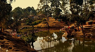
Sattal or Sat Tal is an interconnected group of seven freshwater lakes situated in the Lower Himalayan Range near Bhimtal, a town of the Nainital district in Uttarakhand, India. During the British Raj, the area had a tea plantation, one of four in the Kumaon area at that time.

<span class="mw-page-title-main">Wular Lake</span> Fresh water lake in Jammu and Kashmir, India

Wular Lake, also known as Wolar in Kashmiri, is one of the largest fresh water lakes in South Asia. It is located near Bandipora town in the Bandipora district of Jammu and Kashmir, India. The lake basin was formed as a result of tectonic activity and is fed by the Jhelum River and stream Madhumati and Arin.

<span class="mw-page-title-main">Pithoragarh</span> Town in Kumaon division, Uttarakhand, India

Pithoragarh is a Himalayan town with a Municipal Board in Pithoragarh district in the Indian state of Uttarakhand. It is the largest hill town in Kumaon Division.

<span class="mw-page-title-main">Bhimtal Lake</span> Lake in Uttarakhand, India

Bhimtal is a lake in the town of Bhimtal, near Nainital city in Nainital district of Kumaon, India with a masonry dam built in 1883 creating the storage facility. It is the largest lake of Nainital district, as well as Kumaon, which is known as the "Lake district of India".

<span class="mw-page-title-main">Bhowali</span> Town in Uttarakhand, India

Bhowali is a town and a municipal board in Nainital District in the state of Uttarakhand, India. It is situated at a distance of 11 km (6.8 mi) from the city of Nainital, the district headquarters; at an average elevation of 1,654 m (5,427 ft) from sea level. It is the seat of Bhowali tehsil, one of the eight subdivisions of Nainital district.

<span class="mw-page-title-main">Maharana Pratap Sagar</span> Reservoir in India

Maharana Pratap Sagar, also known as Pong Reservoir or Pong Dam Lake is a large reservoir in Fatehpur, Jawali and Dehra tehsil of Kangra district of the state of Himachal Pradesh in India. It was created in 1975, by building the highest earthfill dam in India on the Beas River in the wetland zone of the Siwalik Hills. Named in the honour of Maharana Pratap (1540–1597), the reservoir or the lake is a well-known wildlife sanctuary and one of the 49 international wetland sites declared in India by the Ramsar Convention. The reservoir covers an area of 24,529 hectares, and the wetlands portion is 15,662 hectares.

<span class="mw-page-title-main">Lake Pichola</span> Lake in Rajasthan, India

Lake Pichola, situated in Udaipur city in the Indian state of Rajasthan, is an artificial fresh water lake, created in the year 1362, named after the nearby Picholi village. It is one of the several contiguous lakes, and developed over the last few centuries in and around the famous Udaipur city. The lakes around Udaipur were primarily created by building dams to meet the drinking water and irrigation needs of the city and its neighbourhood. Two islands, Jag Niwas and Jag Mandir are located within Pichola Lake, and have been developed with several palaces to provide views of the lake.

<span class="mw-page-title-main">Lakes of Kumaon hills</span> Group of lakes in the Nainital district of Kumaon, India

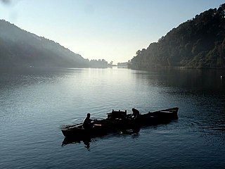
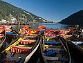
The Lakes of Kumaon hills are a group of lakes located in the Nainital district, Kumaon. Nainital district is also called the ‘Lake District’ of India. These are under restoration with funds provided by the National Lake Conservation Plan (NLCP) of the Government of India. The major lakes are the Nainital, Bhimtal, Sat Tal (Sattal) and the Naukuchiatal

<span class="mw-page-title-main">Berijam Lake</span> Freshwater reservoir in Tamil Nadu, South India

Berijam Lake is a reservoir near Kodaikanal town in Dindigul district of Tamil Nadu, South India. It is at the old site of "Fort Hamilton", in the upper Palani hills. The lake, created by a dam with sluice outlets, is part of a micro–watershed development project. Periyakulam town, 18.7 kilometres (11.6 mi) to the SE, gets its public drinking water from the lake. The lake's water quality is excellent.

<span class="mw-page-title-main">Naukuchiatal</span> Fresh Water Lake in Uttarakhand, India

Naukuchiatal or "lake of nine corners" is a small hill station, near Nainital Town in Nainital district of Kumaon, Uttarakhand, India. The chairman is Devendra Singh chanotiya.

National Highway 109, , is a highway in India which runs in the Indian state of Uttarakhand. It is one of the most important routes, connecting the entire Kumaon region to the state as well as the country. It is also the major route towards the hill stations such as Nainital, Kausani, Ranikhet, Mukteswar and Almora from Delhi. Previously known as NH 87, it was renumbered as NH 109 in 2010. The northern terminal is at NH 7 near Karnaprayag and the southern terminal is at National Highway 9 near Rudrapur. More than 10,000 vehicles travel through NH-109 in tourist season.

<span class="mw-page-title-main">Bhullatal</span>

Bhullatal, an artificial manmade lake dedicated to the Garhwali youth of The Garhwal Rifles who helped in construction of the lake, located at just 1 km from the Lansdowne, India.

<span class="mw-page-title-main">Sarju</span> River in Uttarakhand, India

The Sarju, also known as Sarayu, is a major river draining Central Kumaon region in the Indian state of Uttarakhand. Originating from Sarmul, Sarju flows through the cities of Kapkot, Bageshwar and Seraghat before joining Mahakali at Pancheshwar. The Sarju is the largest tributary of the Sharda River. The river forms the South-eastern border between the districts of Pithoragarh and Almora. Temperate and sub-Tropical forests cover the entire Catchment area of the River.

Ahansar Lake is a rural freshwater ox-bow lake located in close vicinity of Manasbal Lake in Ahan village, Ganderbal district, Jammu and Kashmir, India. It is situated approximately 26 kilometers northwest of Srinagar city within the geographical coordinates of 34° 18´ N latitude and 74° 39´ E longitude. The lake is classified as a semi-drainage type with a maximum depth of 4.80 meters and covers an area of 0.80 square kilometers. It is located at an altitude of 1584 meters above sea level.

References

  1. 1 2 3 4 5 6 7 Executive Summary, Conservation and Management Plan for Nainital Lake
  2. 1 2 "Inventory of Wetlands, Nainital, p.431" (PDF). Archived from the original (PDF) on 3 March 2016. Retrieved 8 November 2008.
  3. Management of Lakes in India, Annex 2
  4. http://nainital.nic.in/history.htm Nainital History
  5. 1 2 3 4 5 Introduction, Horticulture, Medicinal flora, Animals and Fishes Archived 7 April 2008 at the Wayback Machine
  6. Metal fractionation study on bed sediments of Lake Nainital, National Institute of Hydrology, Roorkee, Uttaranchal, India
  7. 1 2 http://www.india-today.com/itoday/20010205/profile.shtml Lady of the lake, Profile: Aradhana Shukla
  8. Renewed focus on urban, rural water supply
  9. company that proposed, installed and commissioned aeration work
  10. Hogan, Lauren (27 April 2016). Thames Half Rater “Black Cap” – BAE0002. National Maritime Museum Cornwall.
  11. Kamath, Sucharita (16 Oct, 2015). Governor's Gold Cup 2015 at Nainital Yacht Club. YachtsandYachting.com.
  12. 1 2 Nainital Tourism