Nanda Devi is the second-highest mountain in India, after Kangchenjunga, and the highest located entirely within the country. Nanda Devi is the 23rd-highest peak in the world.

Kamet is the second-highest mountain in the Garhwal region of Uttarakhand, India, after Nanda Devi. It lies in the Chamoli District of Uttarakhand. Its appearance resembles a giant pyramid topped by a flat summit area with two peaks.

A jökulhlaup is a type of glacial outburst flood. It is an Icelandic term that has been adopted in glaciological terminology in many languages. It originally referred to the well-known subglacial outburst floods from Vatnajökull, Iceland, which are triggered by geothermal heating and occasionally by a volcanic subglacial eruption, but it is now used to describe any large and abrupt release of water from a subglacial or proglacial lake/reservoir.
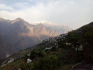
Joshimath, also known as Jyotirmath, is a town and a municipal board in Chamoli District in the Indian state of Uttarakhand. Located at a height of 6,150 feet, it is a gateway to several Himalayan mountain climbing expeditions, trekking trails and pilgrim centres like Badrinath. It is home to one of the four cardinal pīthas established by Adi Shankara.

Chamoli district is a district of the Uttarakhand state of India. It is bounded by the Tibet region to the north, and by the Uttarakhand districts of Pithoragarh and Bageshwar to the east, Almora to the south, Pauri Garhwal to the southwest, Rudraprayag to the west, and Uttarkashi to the northwest. The administrative headquarters of Chamoli district is in Gopeshwar.

The Alaknanda is a turbulent Himalayan river in the Indian state of Uttarakhand and one of the two headstreams of the Ganges, the major river of Northern India and the holy river of Hinduism. In hydrology, the Alaknanda is considered the source stream of the Ganges on account of its greater length and discharge; while, in Hindu tradition and culture, the other headstream, the Bhagirathi, is considered the source stream.

Glacial motion is the motion of glaciers, which can be likened to rivers of ice. It has played an important role in sculpting many landscapes. Most lakes in the world occupy basins scoured out by glaciers. Glacial motion can be fast or slow, but is typically around 25 centimetres per day (9.8 in/d).
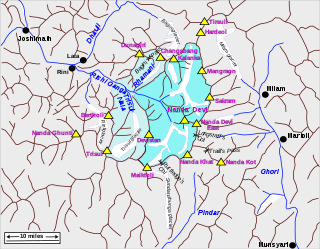
The Nanda Devi National Park or Nanda Devi Biosphere Reserve, established in 1982 is a national park situated around the peak of Nanda Devi in Chamoli Garhwal district of Uttarakhand, in northern India. The entire park lies at an elevation of more than 3,500 m (11,500 ft) above mean sea level.

A glacial lake outburst flood (GLOF) is a type of outburst flood caused by the failure of a dam containing a glacial lake. An event similar to a GLOF, where a body of water contained by a glacier melts or overflows the glacier, is called a jökulhlaup. The dam can consist of glacier ice or a terminal moraine. Failure can happen due to erosion, a buildup of water pressure, an avalanche of rock or heavy snow, an earthquake or cryoseism, volcanic eruptions under the ice, or massive displacement of water in a glacial lake when a large portion of an adjacent glacier collapses into it.

The Dhauliganga is a turbulent Himalayan river which rises in the border regions of India and China and flows south into the Garhwal region of Uttarakhand, India. It joins the Alaknanda, the major source stream of the Ganges river.

Uttarakhand has a total geographic area of 53,483 km2, of which 86% is mountainous and 65% is covered by forest. Most of the northern parts of the state are part of Greater Himalaya ranges, covered by the high Himalayan peaks and glaciers, while the lower foothills were densely forested till denuded by the British log merchants and later, after independence, by forest contractors. Recent efforts in reforestation, however, have been successful in restoring the situation to some extent. The unique Himalayan ecosystem plays host to many animals, plants and rare herbs. Two of India's great rivers, the Ganges and the Yamuna take birth in the glaciers of Uttarakhand, and are fed by myriad lakes, glacial melts and streams.
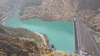
The Dhauliganga Dam was a concrete face rock and earth-fill embankment dam on the Dhauliganga River near Dharchula in Uttarakhand, India, close to the borders with Tibet and Nepal. It had very little pondage and operated as run-of-the-river. It was constructed by a joint venture of Kajima Construction Corporation, Ltd., and Daewoo Engineering & Construction with Bauer Maschinen. HRT & PH was constructed by JV of [HCC, Hindustan Construction Company] and Samsung Corporation [E&C] Group. It generates 280 MW(4x70 MW) of hydro power.
The Tapovan Vishnugad Hydropower Plant is a 520 MW run-of-river hydroelectric project being constructed on Dhauliganga River in Chamoli District of Uttarakhand, India. The plant is expected to generate over 2.5 TWh of electricity annually.
Deo Damla is a mountain of the Garhwal Himalaya in Uttarakhand, India. It is situated in the eastern rim of Nanda Devi Sanctuary on the watershed of Milam Glacier and Nanda Devi basin. The elevation of Deo Damla is 6,620 metres (21,719 ft) and its prominence is 693 metres (2,274 ft). It is 63rd highest located entirely within the Uttrakhand. Nanda Devi, is the highest mountain in this category. It lies 1.8 km SSE of Mangraon 6,568 metres (21,549 ft). Its nearest higher neighbor Rishi Pahar 6,992 metres (22,940 ft) lies 8.3 km NNW and it is 10.6 km SSW of Nanda Devi 7,816 metres (25,643 ft). It lies 1.4 km north of Bamchu 6,303 metres (20,679 ft).
Chorabari Lake, also known as Gandhi Sarovar, was a glacial lake at the snout of the Chorabari Glacier at an altitude of 3,900 m (12,800 ft). It was about 2 km (1.2 mi) upstream from the town of Kedarnath in the Indian state of Uttarakhand, part of the Mandakini River system. On 17 June 2013, the moraine holding back the waters of the lake gave way and vast quantities of water cascaded down the valley below, causing a catastrophic flash flood. The lake did not reform after the event because much of the moraine had been washed away, leaving a boulder-strewn flat area with a small stream flowing through it.

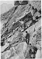
The 2021 Uttarakhand flood, also known as the Chamoli disaster, began on 7 February 2021 in the environs of the Nanda Devi National Park, a UNESCO World Heritage Site in the outer Garhwal Himalayas in Uttarakhand state, India. It was caused by a large rock and ice avalanche consisting of material dislodged from Ronti peak. It caused flooding in the Chamoli district, most notably in the Rishiganga river, the Dhauliganga river, and in turn the Alaknanda—the major headstream of the Ganges. The disaster left over 200 killed or missing. Most were workers at the Tapovan dam site.
Dakshini Nanda Devi Glacier is a glacier in Chamoli district, Uttarakhand, India. With Uttari Nanda Devi Glacier, Dakshini Nanda Devi Glacier flanks Nanda Devi peak and also feeds the Rishiganga river. Nanda Khat is also near.
Raini is a village in Chamoli district in Uttarakhand, north India. Rini is located on the river banks at the confluence of Rishi Ganga and Dhauli Ganga rivers.

Nanda Devi Glacier is a glacier in Chamoli district, Uttarakhand, India. It is near Nanda Devi.
2021 saw some of the most extreme flooding on record, in large part driven by climate change. The insurance industry analysis group Swiss RE found that 31% of global insurance losses were from flooding, and that nearly a fifth of the economic damage from natural disasters was uninsured.