
Nanda Devi is the second-highest mountain in India, after Kangchenjunga, and the highest located entirely within the country. It is the 23rd-highest peak in the world.
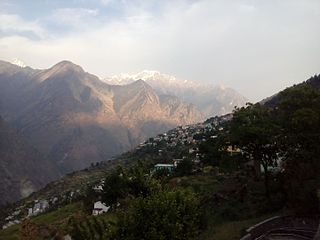
Joshimath, also known as Jyotirmath, is a city and a municipal board in Chamoli District in the Indian state of Uttarakhand. Located at a height of 6,150 feet, it is a gateway to several Himalayan mountain climbing expeditions, trekking trails and pilgrim centres like Badrinath. It is home to one of the four cardinal pīthas established by Adi Shankara.

Chamoli district is a district of the Uttarakhand state of India. It is bounded by the Tibet region to the north, and by the Uttarakhand districts of Pithoragarh and Bageshwar to the east, Almora to the south, Pauri Garhwal to the southwest, Rudraprayag to the west, and Uttarkashi to the northwest. The administrative headquarters of Chamoli district is in Gopeshwar.

The Alaknanda is a Himalayan river in the Indian state of Uttarakhand and one of the two headstreams of the Ganges, the major river of Northern India and the holy river of Hinduism. In hydrology, the Alaknanda is considered the source stream of the Ganges on account of its greater length and discharge; however, in Hindu tradition and culture, the other headstream, the Bhagirathi, is considered the source stream.
The Nanda Devi National Park or Nanda Devi Biosphere Reserve, established in 1982 is a national park situated around the peak of Nanda Devi in Chamoli Garhwal district of Uttarakhand, in northern India. The entire park lies at an elevation of more than 3,500 m (11,500 ft) above mean sea level.

The Dhauliganga is a turbulent Himalayan river which rises in the border regions of India and China and flows south into the Garhwal region of Uttarakhand, India. It joins the Alaknanda, the major source stream of the Ganges river.
Malari in the Dhauli Ganga valley of the Nanda Devi Biosphere reserve is a small village near the Tibet border. This area has been declared as a world heritage site. Located 61 km from Joshimath, the nearest Tehsil, in Chamoli District of Uttarakhand.
The Tapovan Vishnugad Hydropower Plant is a 520 MW run-of-river hydroelectric project being constructed on Dhauliganga River in Chamoli District of Uttarakhand, India. The plant is expected to generate over 2.5 TWh of electricity annually.

Kalanka is a mountain of Garhwal Himalaya in Uttarakhand, India. Kalanka stands at 6931 meter 22740 feet. It's the 20th highest located entirely within the Uttrakhand. Nanda Devi is the highest mountain in this category. Kalanka is the 48th highest peak in India and 319th highest peak in the world. Southern side of Kalanka is falls under Nanda Devi National Park.
Saf Minal is a mountain of Garhwal Himalaya in Uttarakhand India. Saf Minal standing majestically at 6911 meter 22674 feet. It's the 21st highest located entirely within the uttrakhand India. Nanda Devi, is the highest mountain in this category and 50th highest peak in India. Saf Minal is the 332nd highest peak in the world. Saf Minal falls on the edge of the Northern Nanda Devi National Park.
Devistan I is a mountain of the Garhwal Himalaya located in the Chamoli district of Uttarakhand, India. The elevation of Devistan I is 6,678 metres (21,909 ft) and its prominence is 702 metres (2,303 ft). It is 52nd highest located entirely within the Uttrakhand. Nanda Devi is the highest mountain in this category. It stands on the western rim of the Nanda Devi Sanctuary. It lies between the Devisthan II 6,529 metres (21,421 ft) and Devtoli 6,788 metres (22,270 ft). Its nearest higher neighbor Devtoli 6,932 metres (22,743 ft) lies 6.6 km SSW. It is located 1 km South of Devisthan II and 9.6 km NE lies Nanda Devi 7,816 metres (25,643 ft).
Devistan II is a mountain of the Garhwal Himalaya located in the Chamoli district of Uttarakhand, India. Devistan means land of Goddess. The elevation of Devistan II is 6,529 metres (21,421 ft) and its prominence is 214 metres (702 ft). It is 81st joint highest located entirely within the Uttrakhand. Nanda Devi, is the highest mountain in this category. It stands on the western rim of the Nanda Devi Sanctuary. It lies 1 km North of Devistan I 6,678 metres (21,909 ft) and 7.5 km NNE of Devtoli 6,788 metres (22,270 ft) its nearest higher neighbor. Trisul 7,120 metres (23,360 ft) lies 10.6 km WSW and 9.2 km ENE lies Nanda Devi 7,816 metres (25,643 ft).
Rishi Kot is a mountain of the Garhwal Himalaya in Uttarakhand India. Rishi Kot means “the Rishis’ fortress”. The elevation of Rishi Kot is 6,236 metres (20,459 ft) and its prominence is 436 metres (1,430 ft). It is 134th joint highest located entirely within the Uttrakhand. Nanda Devi, is the highest mountain in this category. It lies 5.7 km SW of Changabang 6,864 metres (22,520 ft) its nearest higher neighbor and 7.1 km south of Dunagiri 7,066 metres (23,182 ft). Bethartoli 6,393 metres (20,974 ft) lies 13.4 km SW and 11.7 km SSE lies Nanda Devi 7,816 metres (25,643 ft).
Bamchu is a mountain of the Garhwal Himalaya in Uttarakhand India. It's situated on the eastern rim of Nanda Devi Sanctuary on the watershed of Milam Glacier and Nanda Devi basin. The elevation of Bamchu is 6,303 metres (20,679 ft) and its prominence is 241 metres (791 ft). It is 124th highest located entirely within the Uttrakhand. Nanda Devi, is the highest mountain in this category. It lies 3.4 km South of Deo Damla 6,620 metres (21,719 ft) its nearest higher neighbor and 3.1 km SSE of Mangraon 6,568 metres (21,549 ft). Kalanka 6,931 metres (22,740 ft) lies 9.8 km NNW and 9.3 km SW lies Nanda Devi 7,816 metres (25,643 ft).
Lhatu Dhura is a mountain of the Garhwal Himalaya in Uttarakhand, India. It is situated in the eastern rim of the Nanda Devi Sanctuary, on the watershed of the Milam Glacier and the Nanda Devi basin. The elevation of Lhatu Dhura is 6,392 metres (20,971 ft) and its prominence is 229 metres (751 ft). It is joint 103rd highest mountain located entirely within Uttrakhand. It lies 4.6 km south of Sakram 6,254 metres (20,518 ft). Its nearest higher neighbor Nanda Devi East lies 4.5 km to the south west, and Deo Damla lies 7.7 km to the north; it is 6.1 km east-north-east of Nanda Devi, and 9.5 km south of Mangraon.
Lohar Deo is a mountain of the Garhwal Himalaya in Uttarakhand, India. It is situated in the eastern rim of Nanda Devi Sanctuary on the watershed of Milam Glacier and Nanda Devi basin. The elevation of Lohar Deo is 6,245 metres (20,489 ft) and its prominence is 222 metres (728 ft). It is joint 133rd highest located entirely within the Uttrakhand. Nanda Devi, is the highest mountain in this category. Lohar Deo situated between Sakram in the south west and Bamchu on the north west. It lies 1.2 km NNE of Sakram 6,254 metres (20,518 ft). Its nearest higher neighbor Deo Damla 6,620 metres (21,719 ft) lies 2.6 km NW. Bamchu 6,303 metres (20,679 ft) lies 1.8 km NW and it is 9.9 km NE of Nanda Devi 7,816 metres (25,643 ft). It lies 11.6 km SE of Kalanka 6,931 metres (22,740 ft).
Devi Mukut is a mountain of the Garhwal Himalaya in Uttarakhand, India. It stands near the western rim of the Nanda Devi Sanctuary between Devistan and Devtoli. The elevation of Devi Mukut is 6,648 metres (21,811 ft). It is 59th highest located entirely within the Uttrakhand. Nanda Devi, is the highest mountain in this category. It lies 3.3 km south of Devistan I 6,678 metres (21,909 ft) its nearest higher neighbor. Devtoli 6,788 metres (22,270 ft) stands at 3.3 km SSW. It stands 4.3 km north of Maiktoli 6,803 metres (22,320 ft) and Nanda Devi lies 11.9 km NE.

The 2021 Uttarakhand flood, also known as the Chamoli disaster, began on 7 February 2021 in the environs of the Nanda Devi National Park, a UNESCO World Heritage Site in the outer Garhwal Himalayas in Uttarakhand state, India. It was caused by a large rock and ice avalanche consisting of material dislodged from Ronti peak. It caused flooding in the Chamoli district, most notably in the Rishiganga river, the Dhauliganga river, and in turn the Alaknanda—the major headstream of the Ganges. The disaster left over 200 killed or missing. Most were workers at the Tapovan dam site.
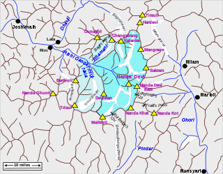
Rishiganga is a river in the Chamoli district, Uttarakhand, India. It springs from the Uttari Nanda Devi Glacier on the Nanda Devi mountain. It is also fed from the Dakshini Nanda Devi Glacier. Continuing through the Nanda Devi National Park, it flows into the Dhauliganga River near the village Rini.

Nanda Devi Glacier is a glacier in Chamoli district, Uttarakhand, India. It is near Nanda Devi.

