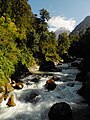
The Pindari Glacier is a glacier found in the upper reaches of the Kumaon Himalayas, to the southeast of Nanda Devi and Nanda Kot.

Chamoli district is a district of the Uttarakhand state of India. It is bounded by the Tibet region to the north, and by the Uttarakhand districts of Pithoragarh and Bageshwar to the east, Almora to the south, Pauri Garhwal to the southwest, Rudraprayag to the west, and Uttarkashi to the northwest. The administrative headquarters of Chamoli district is in Gopeshwar.

The Alaknanda is a turbulent Himalayan river in the Indian state of Uttarakhand and one of the two headstreams of the Ganges, the major river of Northern India and the holy river of Hinduism. In hydrology, the Alaknanda is considered the source stream of the Ganges on account of its greater length and discharge; while, in Hindu tradition and culture, the other headstream, the Bhagirathi, is considered the source stream.

Devprayag is a town and a nagar panchayat, near New Tehri city in Tehri Garhwal District in the state of Uttarakhand, India, and is the final one of the Panch Prayag of Alaknanda River where Alaknanda meets the Bhagirathi river and both rivers thereafter flow on as the Ganges river or Ganga.

Pindari Kanda Traill's Pass is a mountain pass through the Himalayas located between Nanda Devi and Nanda Kot peaks in the Uttarakhand state in the districts of Pithoragarh and Bageshwar in India.

Nanda Kot is a mountain peak of the Himalaya range located in the Pithoragarh district of Uttarakhand state in India. It lies in the Kumaon Himalaya, just outside the ring of peaks enclosing the Nanda Devi Sanctuary, 15 kilometres (9 mi) southeast of Nanda Devi itself. The name Nanda Kot literally means "Nanda's Fortress" and refers to the abode of one of the sacred forms of the Hindu Goddess Parvati who in legend has made her sanctuary amongst the ring of lofty mountains in the region.

Karnaprayag is a town and municipal board in the Chamoli District in the Indian state of Uttarakhand. Karnaprayag is one of the Panch Prayag of Alaknanda River, situated at the confluence of the Alaknanda and Pindar River.

Nandaprayag is a town and a nagar panchayat in Chamoli district in the Indian state of Uttarakhand. Nandaprayag is one of the Panch Prayag of Alaknanda River and lies at the confluence of the Alaknanda River and Nandakini River. Nandaprayag was once the capital of the Yadu kingdom.

The Dhauliganga is a turbulent Himalayan river which rises in the border regions of India and China and flows south into the Garhwal region of Uttarakhand, India. It joins the Alaknanda, the major source stream of the Ganges river.

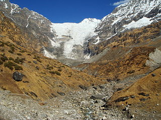
The Satopanth glacier is situated in the Indian state of Uttarakhand. The river Alaknanda, one of the primary headstreams of the Ganges, has its origin in the Satopanth glacier. The glacier is one of the most popular glaciers in Uttarakhand among tourists. Mountaineers consider it somewhat challenging to scale.
The Kafni Glacier is located in the upper reaches of the Kumaon Himalayas, to the southeast of Nanda Devi. The glacier gives rise to the Kafni River, which is a tributary of the Pindar River. The Pindar River is a tributary to Alaknanda River, which eventually is one of the two headstreams of the Ganges. This is relatively small glacier but a popular trekking destination along with Pindari Glacier.

Panch Prayag is an expression in Hindu religious ethos, specifically used to connote the five sacred river confluences in the Garhwal Himalayas in the state of Uttarakhand, India. The five prayags - prayaga meaning "place of confluence of rivers" in Sanskrit - also termed as "Prayag pentad" are Vishnuprayag, Nandaprayag, Karnaprayag, Rudraprayag and Devprayag, in the descending flow sequence of their occurrence.

Nandakini is a river and one of the six main tributaries of the Ganges. Originating in the glaciers below Nanda Ghunti on the Nanda Devi Sanctuary, the river joins the Alaknanda at Nandprayag (870m), which is one of the panch prayags or holy confluences on the Alaknanda. It Flowing through the Chamoli district of Uttarakhand, this river traverses a distance of around 105 kilometers before eventually converging with the Alaknanda River.
Uttarakhand is a state in the northern part of India. It is often referred to as the "Devbhumi" due to its religious significance and numerous Hindu temples and pilgrimage sites found throughout the state. As a result, religious tourism forms a major portion of the tourism in the state. Uttarakhand is known for the natural environment of the Himalayas. 2019 Tourist Arrivals Domestic – 40,000,000 per/year and Foreigner – 150,000 per year. Tourism business in Uttarakhand generated ₹ 23,000 crores during 2013–14.

Maiktoli is a mountain of Kumaun Himalayas located in the Bageshwar district of Uttarakhand state in India. It stands at 6,803 metres (22,320 ft). It is jointly the 32nd highest located entirely within the uttrakhand India. Nanda Devi is the highest mountain in this category. Maiktoli is 479th highest peak in the world. It is located at the southern rim of Nanda Devi Sanctuary. Maiktoli is located just south east of Devtoli and south east of Trisul. On the north east side lies Nanda Devi and Panwali Dwar. On the south west side lies Tharkot.

Devtoli is a mountain of Kumaon Himalaya located in the Bageshwar district of Uttarakhand,India. It stands at 6,788 metres (22,270 ft). It is 36th highest located entirely within Uttarakhand. Nanda Devi is the highest mountain in this category. It is located at the southern rim of Nanda Devi Sanctuary. Devtoli is located just north west of Maiktoli and east of Mrigthuni. On the north east side lies Nanda Devi and Panwali Dwar on the east side. Tharkot on the southern side.

Panwali Dwar is a mountain of the Kumaun Himalayas located in the Bageshwar district of Uttarakhand, India. The elevation of Panwali Dwar is 6,683 metres (21,926 ft) and its prominence is 763 metres (2,503 ft). It is 55th highest located entirely within the Uttarakhand. Nanda Devi, is the highest mountain in this category. It lies on southern wall of Nanda devi sanctuary. Its nearest higher neighbor Maiktoli 6,803 metres (22,320 ft) lies 8.2 km WSW. It is located 2.6 km SW of Nanda Khat 6,611 metres (21,690 ft) and 9.2 km NE lies Nanda Devi East 7,434 metres (24,390 ft).

Nanda Bhanar is a mountain of the Kumaun Himalaya in Uttarakhand India. The elevation of Nanda Bhanar is 6,236 metres (20,459 ft) and its prominence is 135 metres (443 ft). It is joint 134th highest located entirely within the Uttrakhand. Nanda Devi, is the highest mountain in this category. It lies 1.7 km SSW of Nanda Kot 6,861 metres (22,510 ft) its nearest higher neighbor. Dangthal 6,050 metres (19,849 ft) lies 5.5 km SSE and it is 15.2 km SSE of Nanda Devi 7,816 metres (25,643 ft). It lies 10.8 km north of Panwali Dwar 6,663 metres (21,860 ft).
Nandakhani is a mountain of the Kumaun Himalaya in Uttarakhand India. The elevation of Nandakhani is 6,029 metres (19,780 ft) and its prominence is 69 metres (226 ft). It is 169th highest located entirely within the Uttrakhand. Nanda Devi, is the highest mountain in this category. It lies .932 km SE of Nanda Bhanar 6,236 metres (20,459 ft) its nearest higher neighbor. Dangthal 6,050 metres (19,849 ft) lies 4.6 km SSE and it is 2.2 km SSE of Nanda Kot 6,861 metres (22,510 ft). It lies 19.2 km east of Maiktoli 6,803 metres (22,320 ft).
Tharkot is a mountain of the Kumaon Himalaya in Uttarakhand India. It is situated near the southern rim of Nanda Devi Sanctuary. The elevation of Tharkot is 6,099 metres (20,010 ft) and its prominence is 671 metres (2,201 ft). It is joint 160th highest located entirely within the Uttrakhand. Nanda Devi, is the highest mountain in this category. It lies 7.3 km SSW of Mrigthuni 6,855 metres (22,490 ft). Devtoli 6,788 metres (22,270 ft) lies 7.5 km NNE and it is 10.8 km SSE of Trisul I 7,120 metres (23,360 ft). It lies 7.2 km SW of Maiktoli 6,803 metres (22,320 ft).