
The Alpine region of Switzerland, conventionally referred to as the Swiss Alps, represents a major natural feature of the country and is, along with the Swiss Plateau and the Swiss portion of the Jura Mountains, one of its three main physiographic regions. The Swiss Alps extend over both the Western Alps and the Eastern Alps, encompassing an area sometimes called Central Alps. While the northern ranges from the Bernese Alps to the Appenzell Alps are entirely in Switzerland, the southern ranges from the Mont Blanc massif to the Bernina massif are shared with other countries such as France, Italy, Austria and Liechtenstein.

The Continental Divide of the Americas is the principal, and largely mountainous, hydrological divide of the Americas. The Continental Divide extends from the Bering Strait to the Strait of Magellan, and separates the watersheds that drain into the Pacific Ocean from those river systems that drain into the Atlantic and Arctic Ocean, including those that drain into the Gulf of Mexico, the Caribbean Sea, and Hudson Bay.

Mount Hood is an active stratovolcano in the Cascade Volcanic Arc. It was formed by a subduction zone on the Pacific coast and rests in the Pacific Northwest region of the United States. It is located about 50 mi (80 km) east-southeast of Portland, on the border between Clackamas and Hood River counties. In addition to being Oregon's highest mountain, it is one of the loftiest mountains in the nation based on its prominence, and it offers the only year-round lift-served skiing in North America.

The Karakoram is a mountain range in the Kashmir region spanning the border of Pakistan, China, and India, with the northwestern extremity of the range extending to Afghanistan and Tajikistan. Most of the Karakoram mountain range falls under the jurisdiction of Gilgit-Baltistan, which is controlled by Pakistan. Its highest peak, K2, is located in Gilgit-Baltistan, Pakistan. It begins in the Wakhan Corridor (Afghanistan) in the west, encompasses the majority of Gilgit-Baltistan, Pakistan and extends into Ladakh and Aksai Chin.
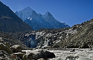
Gangotriglacier is located in Uttarkashi District, Uttarakhand, India in a region bordering Tibet. This glacier, one of the primary sources of the Ganges, has a volume of over 27 cubic kilometers. The glacier is about 30 kilometres long and 2 to 4 km wide. Around the glacier are the peaks of the Gangotri Group, including several peaks notable for extremely challenging climbing routes, such as Shivling, Thalay Sagar, Meru, and Bhagirathi III. It flows roughly northwest, originating in a cirque below Chaukhamba, the highest peak of the group.

Glacier Peak or Dakobed is the most isolated of the five major stratovolcanoes of the Cascade Volcanic Arc in the U.S state of Washington. Located in the Glacier Peak Wilderness in Mount Baker–Snoqualmie National Forest, the volcano is visible from the west in Seattle, and from the north in the higher areas of eastern suburbs of Vancouver such as Coquitlam, New Westminster and Port Coquitlam. The volcano is the fourth tallest peak in Washington state, and not as much is known about it compared to other volcanoes in the area. Local Native Americans have recognized Glacier Peak and other Washington volcanoes in their histories and stories. When American explorers reached the region, they learned basic information about surrounding landforms, but did not initially understand that Glacier Peak was a volcano. Positioned in Snohomish County, the volcano is only 70 miles (110 km) northeast of downtown Seattle. From locations in northern Seattle and northward, Glacier Peak is closer than the more famous Mount Rainier (Tahoma), but as Glacier Peak is set farther into the Cascades and almost 4,000 feet (1,200 m) shorter, it is much less noticeable than Mount Rainier.

Nanda Devi is the second-highest mountain in India, after Kangchenjunga, and the highest located entirely within the country. Nanda Devi is the 23rd-highest peak in the world.

Pindari Kanda Traill's Pass is a mountain pass through the Himalayas located between Nanda Devi and Nanda Kot peaks in the Uttarakhand state in the districts of Pithoragarh and Bageshwar in India.

Nanda Kot is a mountain peak of the Himalaya range located in the Pithoragarh district of Uttarakhand state in India. It lies in the Kumaon Himalaya, just outside the ring of peaks enclosing the Nanda Devi Sanctuary, 15 kilometres (9 mi) southeast of Nanda Devi itself. The name Nanda Kot literally means "Nanda's Fortress" and refers to the abode of one of the sacred forms of the Hindu Goddess Parvati who in legend has made her sanctuary amongst the ring of lofty mountains in the region.

Changuch is a Himalayan mountain peak situated at the boundary of Pithoragarh and Bageshwar district of the Uttarakhand state of India. This peak is situated above the Pindari Glacier. This peak offers a ridge leading to Nanda Kot. On its massif Traill's pass is situated, which connects Pindari valley to Goriganga valley. The first successful ascent to the peak was made by an Indo-British team on 9 June 2009 at 9 am.

The Clearwater River is the largest tributary of the North Thompson River, joining it at the community of Clearwater, British Columbia. The Clearwater rises from glaciers in the Cariboo Mountains and flows in a mostly southerly direction for 201 km (125 mi) to the North Thompson. Its entire course, except the last 5 km (3 mi), is within Wells Gray Provincial Park. Its confluence with the North Thompson is protected by North Thompson River Provincial Park.

The Pindar River is a river located in Uttarakhand, India. The Pindar originates from Pindari Glacier which is located in Bageshwar district of Kumaon region in Uttarakhand. The source of this river, the Pindar glacier is located at an altitude of 3,820 m (12,530 ft). Pindar glacier has relatively easier access and has been documented well for its retreat over 100 years. Pindar river mouth is located at Karnaprayag where it flows into Alaknanda River.
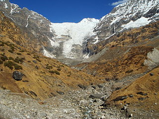
The Kafni Glacier is located in the upper reaches of the Kumaon Himalayas, to the southeast of Nanda Devi. The glacier gives rise to the Kafni River, which is a tributary of the Pindar River. The Pindar River is a tributary to Alaknanda River, which eventually is one of the two headstreams of the Ganges. This is relatively small glacier but a popular trekking destination along with Pindari Glacier.

The Shipton–Tilman Nanda Devi expeditions took place in the 1930s. Nanda Devi is a Himalayan mountain in what was then the Garhwal District in northern India, just west of Nepal, and at one time it was thought to be the highest mountain in the world.
Rishi Kot is a mountain of the Garhwal Himalaya in Uttarakhand India. Rishi Kot means “the Rishis’ fortress”. The elevation of Rishi Kot is 6,236 metres (20,459 ft) and its prominence is 436 metres (1,430 ft). It is 134th joint highest located entirely within the Uttrakhand. Nanda Devi, is the highest mountain in this category. It lies 5.7 km SW of Changabang 6,864 metres (22,520 ft) its nearest higher neighbor and 7.1 km south of Dunagiri 7,066 metres (23,182 ft). Bethartoli 6,393 metres (20,974 ft) lies 13.4 km SW and 11.7 km SSE lies Nanda Devi 7,816 metres (25,643 ft).

Nanda Bhanar is a mountain of the Kumaun Himalaya in Uttarakhand India. The elevation of Nanda Bhanar is 6,236 metres (20,459 ft) and its prominence is 135 metres (443 ft). It is joint 134th highest located entirely within the Uttrakhand. Nanda Devi, is the highest mountain in this category. It lies 1.7 km SSW of Nanda Kot 6,861 metres (22,510 ft) its nearest higher neighbor. Dangthal 6,050 metres (19,849 ft) lies 5.5 km SSE and it is 15.2 km SSE of Nanda Devi 7,816 metres (25,643 ft). It lies 10.8 km north of Panwali Dwar 6,663 metres (21,860 ft).
Nandakhani is a mountain of the Kumaun Himalaya in Uttarakhand India. The elevation of Nandakhani is 6,029 metres (19,780 ft) and its prominence is 69 metres (226 ft). It is 169th highest located entirely within the Uttrakhand. Nanda Devi, is the highest mountain in this category. It lies .932 km SE of Nanda Bhanar 6,236 metres (20,459 ft) its nearest higher neighbor. Dangthal 6,050 metres (19,849 ft) lies 4.6 km SSE and it is 2.2 km SSE of Nanda Kot 6,861 metres (22,510 ft). It lies 19.2 km east of Maiktoli 6,803 metres (22,320 ft).
Tharkot is a mountain of the Kumaon Himalaya in Uttarakhand India. It is situated near the southern rim of Nanda Devi Sanctuary. The elevation of Tharkot is 6,099 metres (20,010 ft) and its prominence is 671 metres (2,201 ft). It is joint 160th highest located entirely within the Uttrakhand. Nanda Devi, is the highest mountain in this category. It lies 7.3 km SSW of Mrigthuni 6,855 metres (22,490 ft). Devtoli 6,788 metres (22,270 ft) lies 7.5 km NNE and it is 10.8 km SSE of Trisul I 7,120 metres (23,360 ft). It lies 7.2 km SW of Maiktoli 6,803 metres (22,320 ft).

The 2021 Uttarakhand flood, also known as the Chamoli disaster, began on 7 February 2021 in the environs of the Nanda Devi National Park, a UNESCO World Heritage Site in the outer Garhwal Himalayas in Uttarakhand state, India. It was caused by a large rock and ice avalanche consisting of material dislodged from Ronti peak. It caused flooding in the Chamoli district, most notably in the Rishiganga river, the Dhauliganga river, and in turn the Alaknanda—the major headstream of the Ganges. The disaster left over 200 killed or missing. Most were workers at the Tapovan dam site.

The Garden of Eden Ice Plateau is a large ice field on the western side of New Zealand's Southern Alps / Kā Tiritiri o te Moana. At over 9 km (5.6 mi) long, the Garden of Eden is one of the largest ice fields in New Zealand, along with the equally-sized Garden of Allah Ice Field which sits just to the north. The ice field is one of many geographic features in the area between the main divide of the Southern Alps and the Adams Range which share biblical names, a convention first established by the earliest explorers to the area. The Garden's remote location and difficult conditions make research difficult, especially with restrictions on helicopter landings imposed through the designation of the area as Adams Wilderness Area in 2003. Despite this, the ice plateau has been a popular destination for tramping groups for over 80 years, with access routes from both coasts and easily reachable areas once on the plateau itself.


