Pashulok Barrage

Last updated

Pashulok Barrage
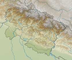
India Uttarakhand relief map.svg
Red pog.svg
Location of Pashulok Barrage in Uttarakhand
CountryIndia
Location Rishikesh
Coordinates 30°04′27″N78°17′18″E / 30.07417°N 78.28833°E / 30.07417; 78.28833 Coordinates: 30°04′27″N78°17′18″E / 30.07417°N 78.28833°E / 30.07417; 78.28833
StatusOperational
Dam and spillways
Impounds Ganges River
Length320 m (1,050 ft)
Spillway capacity13,200 m3/s (466,154 cu ft/s)
Reservoir
Catchment area 21,400 km2 (8,263 sq mi)
Normal elevation330 m (1,083 ft) [1]
Power Station
Commission date1980
Hydraulic head 32.5 m (107 ft)
Turbines 4 x 36 MW (48,000 hp) Kaplan-type
Installed capacity 144 MW (193,000 hp)

The Pashulok Barrage is a barrage located on the Ganges River just south of Rishikesh in Dehradun district, Uttarakhand, India.
Contents

Chilla Power Plant

In a run-of-the-river scheme, the main purpose of the barrage is to divert water into a canal on the east bank of the river which feeds water to the Chilla Power Plant downstream at 29°58′34″N78°13′11″E / 29.97611°N 78.21972°E / 29.97611; 78.21972 (Chilla Power Plant) , 4 km (2 mi) upstream of Haridwar. The power station contains four 36 megawatts (48,000 hp) Kaplan turbine-generators for an installed capacity of 144 megawatts (193,000 hp). The change in elevation between the plant's intake and tailrace affords is a hydraulic head of 32.5 m (107 ft). The design discharge of the plant is 560 m3/s (19,776 cu ft/s). [2]

See also

Related Research Articles

<span class="mw-page-title-main">Yamuna</span> River in India

The Yamuna is the second-largest tributary river of the Ganges by discharge and the longest tributary in India. Originating from the Yamunotri Glacier at a height of about 4,500 m (14,800 ft) on the southwestern slopes of Bandarpunch peaks of the Lower Himalaya in Uttarakhand, it travels a total length of 1,376 kilometres (855 mi) and has a drainage system of 366,223 square kilometres (141,399 sq mi), 40.2% of the entire Ganges Basin. It merges with the Ganges at Triveni Sangam, Allahabad, which is a site of the Kumbh Mela, a Hindu festival held every 12 years.

<span class="mw-page-title-main">Bhavani River</span> River in Bhavani, India

Bhavani is an Indian river which flows through Indian states of Kerala and Tamil Nadu, India. It originates from the Western Ghats of Kerala and is one among the three rivers of Kerala which flows in eastward direction.

Cochrane Dam is a minor earthfill embankment dam with concrete spillway across Georges Creek, located in the South Coast region of New South Wales, Australia. The main purpose of the dam is to supply water for hydro-power at the downstream Brown Mountain Power Station and for irrigation purposes. The impounded reservoir is called Cochrane Lake.

<span class="mw-page-title-main">Asan Barrage</span> Dam in Dakpathar, Uttarakhand

The Asan Barrage is a barrage in the Uttarakhand-Himachal Pradesh border region in Doon Valley,, northern India, situated at the confluence of the Eastern Yamuna Canal and the Asan River and about 11 km (7 mi) from Dakpathar, and 28 km. northwest of Dehradun in Uttarakhand. The barrage is 287.5m long and has water throughout the year which is fed from the river Asan and the discharge channel of the river Yamuna. Since 2020 it has been declared as Uttarakhand's first Ramsar site.

<span class="mw-page-title-main">Srisailam Dam</span> Dam in Telangana and Andhra Pradesh, India

The Srisailam Dam is constructed across the Krishna River in Nagarkurnool district, Telangana and Nandyal district, Andhra Pradesh near Srisailam temple town and is the 2nd largest capacity working hydroelectric station in India.

<span class="mw-page-title-main">Salal Dam</span> Dam in Jammu and Kashmir

Salal Dam, also known as Salal Hydroelectric Power Station, is a run-of-the-river hydropower project on the Chenab River in the Reasi district of the Jammu and Kashmir. It was the first hydropower project built by India in Jammu and Kashmir under the Indus Water Treaty regime. After having reached a bilateral agreement with Pakistan in 1978, with significant concessions made to Pakistan in the design of the dam, reducing its height, eliminating operating pool, and plugging the under-sluices meant for sediment management, India completed the project in 1987. The concessions made in the interest of bilateralism damaged the long-term sustainability of the dam, which silted up in five years. It currently runs at 57% capacity factor. Its long-term future is uncertain.

<span class="mw-page-title-main">Rana Pratap Sagar Dam</span> Dam in Chittorgarh District, Rajasthan

The Rana Pratap Sagar Dam is a gravity masonry dam of 53.8 metres (177 ft) height built on the Chambal River at Rawatbhata in Rajasthan in India. It is part of integrated scheme of a cascade development of the river involving four projects starting with the Gandhi Sagar Dam in the upstream reach in Madhya Pradesh and the Jawahar Sagar Dam on the downstream with a terminal structure of the Kota Barrage in Rajasthan for irrigation.

<span class="mw-page-title-main">Sharda River</span> River along the India–Nepal border

The Sharda River, also called Kali River and Mahakali River, originates at Kalapani in the Himalayas at an elevation of 3,600 m (11,800 ft) in the Pithoragarh district in Uttarakhand, India. It flows along Nepal's western border with India and has a basin area of 14,871 km2 (5,742 sq mi). It joins Ghaghra River, a tributary of the Ganges. It takes the name Kali River from the union of the two streams at Gunji as it flows through the hills. After Brahmadev Mandi near Tanakpur, it enters the Terai plains, where it is called Sharda River.

The Kpong Dam, also known as the Akuse Dam, is a hydroelectric power generating dam on the lower Volta River near Akuse in Ghana. It is owned and operated by Volta River Authority. It was constructed between 1977 and 1982. Its power station has a capacity of 148 megawatts (198,000 hp) with all four units running, though the total nameplate capacity is 160 megawatts (210,000 hp).

The Ranganadi Dam is a concrete-gravity diversion dam on the Ranganadi River in Arunachal Pradesh, India which serves a run-of-the-river scheme.

<span class="mw-page-title-main">Al Wahda Dam (Morocco)</span> Dam in Ouezzane Province, Morocco

Al Wahda Dam, formerly known as M'Jaara Dam, is an embankment dam on the Ouergha River near M´Jaara in Taounate Province, Morocco. It was constructed for flood control, irrigation, water supply and hydroelectric power production. It is the second largest dam in Africa and the largest in Morocco. It was described by Land Ocean Interactions in the Coastal Zone (LOICZ) as "the second most important dam in Africa after the High Aswan dam."

<span class="mw-page-title-main">Ichari Dam</span> Dam in Dakpathar

The Ichari Dam is a concrete gravity dam on the Tons River 13 km (8 mi) north of Dakpathar in Uttarakhand, India. The primary purpose of the dam is hydroelectric power production and it is a run-of-the-river-type. It was completed in 1972. The dam diverts water to the Chibro Power Station which is then returned to the Tons River before being fed to the Khodri Power Station.

<span class="mw-page-title-main">Dakpathar Barrage</span> Dam in Dakpathar

The Dakpathar Barrage is a concrete barrage across the Yamuna River adjacent to Dakpathar in Uttarakhand, India. In a run-of-the-river scheme, the barrage serves to divert water into the East Yamuna Canal for hydroelectric power production at the Dhakrani and Dhalipur Power Plants. The foundation stone for the dam was laid on 23 May 1949 by India's Prime Minister Jawaharlal Nehru. The barrage is controlled by 25 floodgates and has a length of 516.5 m (1,695 ft).

The Dharasu Power Station is a run-of-the-river hydroelectric power station on the Bhagirathi River located at Dharasu in Uttarkashi district, Uttarakhand, India. The power station was commissioned in 2008 and has a 304 MW capacity.

<span class="mw-page-title-main">Ramganga Dam</span> Dam in Kalagrh

The Ramganga Dam, also known as the Kalagarh Dam, is an embankment dam on the Ramganga River 3 km (2 mi) upstream of Kalagarh in Pauri Garhwal district, Uttarakhand, India. It is located within the Jim Corbett National Park.

<span class="mw-page-title-main">Bhimgoda Barrage</span> Dam in Haridwar

The Bhimgoda Barrage, also referred to as the Bhimgoda Weir or Bhimgoda Head Works, is a barrage on the Ganges River at Har ki Pauri near Haridwar in Haridwar district, Uttarakhand, India. Built as the headworks of the Upper Ganges Canal, an initial barrage was completed by 1854 and replaced twice; the final one completed in 1983. The primary purpose for the barrage is irrigation but it also serves to provide water for hydroelectric power production and control floods. The area behind the barrage is known as the Neel Dhara Bird Sanctuary and is a popular destination for various waterbirds and tourists.

The Maneri Dam is a concrete gravity dam on the Bhagirathi River located at Maneri, 8.5 kilometres (5.3 mi) east of Uttarkashi in Uttarkashi district, Uttarakhand, India. The primary purpose of the dam is to divert water into a tunnel which feeds the 90 megawatts (120,000 hp) run-of-the-river Tiloth Power Plant.

<span class="mw-page-title-main">Pandoh Dam</span> Dam in Mandi district

The Pandoh Dam is an embankment dam on the Beas River in Mandi district of Himachal Pradesh, India. Under the Beas Project, the dam was completed in 1977 and its primary purpose is hydroelectric power generation. Part of a run-of-the-river power scheme, it diverts the waters of the Beas to the southwest through a 38 km (24 mi) long system of tunnels and channels. The water is used for power generation at the Dehar Power House before being discharged into the Sutlej River, connecting both rivers. The power house has an installed capacity of 990 MW. The system diverts 256 cumecs of Beas waters to the Satluj River. The project was completed in 1977.

The Bailianhe Pumped Storage Power Station is a pumped-storage hydroelectric power station located 58 kilometres (36 mi) east of Huanggang in Hubei Province, China. It was constructed between 2004 and 2010 and has a 1,200 megawatts (1,600,000 hp) installed capacity. The power station operates by shifting water between an upper and lower reservoir to generate electricity. For this project, only the upper reservoir had to be created as an existing reservoir, the Bailianhe Reservoir, was used as the lower. During periods of low energy demand, such as at night, water is pumped from Bailianhe Reservoir up to the upper reservoir. When energy demand is high, the water is released back down to the lower reservoir but the pump turbines that pumped the water up now reverse mode and serve as generators to produce electricity. The process is repeated as necessary and the plant serves as a peaking power plant.

<span class="mw-page-title-main">Punta Negra Dam</span> Dam in San Juan, San Juan Province

The Punta Negra Dam is a concrete-face rock-fill dam on the San Juan River about 28 kilometres (17 mi) west of San Juan in San Juan Province, Argentina. The purpose of the dam is to provide water for irrigation and the generation of hydroelectric power. The 101 metres (331 ft) tall dam supports a 62-megawatt (83,000 hp) power station and together with the Los Caracoles Dam upstream, it will provide for the irrigation of 15,000 hectares. Construction began in 2009 and the dam and was finished on August 29, 2015. It is being constructed immediately upstream of a diversion barrage.

References

Map all coordinates using: OpenStreetMap  
Download coordinates as: KML
  1. Jain, Sharad K.; Agarwal, Pushpendra K.; Singh, Vijay P. (2007). Hydrology and water resources of India. Dordrecht: Springer. p. 384. ISBN   978-1-4020-5179-1.
  2. "Chilla Power Plant (4x36=144MW)". Uttarakhand Jal Vidyut Nigam Limited. Retrieved 11 July 2011.