The Bhāgīrathī is a turbulent Himalayan river in the Indian state of Uttarakhand, and one of the two headstreams of the Ganges, the major river of Northern India and the holy river of Hinduism. In the Hindu faith, history, and culture, the Bhagirathi is considered the source stream of the Ganges. However, in hydrology, the other headstream Alaknanda, is considered the source stream on account of its great length and discharge. The Bhagirathi and Alaknanda join at Devprayag in Garhwal and are thereafter known as the Ganges.

The Alaknanda is a turbulent Himalayan river in the Indian state of Uttarakhand and one of the two headstreams of the Ganges, the major river of Northern India and a river considered holy in Hinduism. In hydrology, the Alaknanda is considered the source stream of the Ganges on account of its greater length and discharge; while, in Hindu tradition and culture, the other headstream, the Bhagirathi, is considered the source stream.

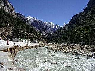
Devprayag is a town and a nagar panchayat, near New Tehri city in Tehri Garhwal District in the state of Uttarakhand, India, and is the final one of the Panch Prayag of Alaknanda River where Alaknanda meets the Bhagirathi river and both rivers thereafter flow on as the Ganges river or Ganga.

Karnaprayag is a town and municipal board in the Chamoli District in the Indian state of Uttarakhand. Karnaprayag is one of the Panch Prayag of Alaknanda River, situated at the confluence of the Alaknanda and Pindar River.

Nandaprayag is a town and a nagar panchayat in Chamoli district in the Indian state of Uttarakhand. Nandaprayag is one of the Panch Prayag of Alaknanda River and lies at the confluence of the Alaknanda River and Nandakini River. Nandaprayag was once the capital of the Yadu kingdom.

Bhilangna River is a Himalayan river in Uttarakhand, India, which is the major tributary of the Bhagirathi river, the source stream of the Ganges River of India. Bhilangana is a combination of Bhil and Ganga.

The Dhauliganga is a turbulent Himalayan river which rises in the border regions of India and China and flows south into the Garhwal region of Uttarakhand, India. It joins the Alaknanda, the major source stream of the Ganges river.

Panch Prayag is an expression in Hindu religious ethos, specifically used to connote the five sacred river confluences in the Garhwal Himalayas in the state of Uttarakhand, India. The five prayags - prayaga meaning "place of confluence of rivers" in Sanskrit - also termed as "Prayag pentad" are Vishnuprayag, Nandaprayag, Karnaprayag, Rudraprayag and Devprayag, in the descending flow sequence of their occurrence.

Vishnuprayāg is the confluence of India's Alaknanda and Dhauliganga rivers—the first of five major confluences of the Alakanda known as the Panch Prayag. It is located at an elevation of 1,372 metres (4,501 ft) in the Chamoli district in the state of Uttarakhand.
Uttarakhand is a state in the northern part of India. It is often referred to as the "Devbhumi" due to its religious significance and numerous Hindu temples and pilgrimage sites found throughout the state. As a result, religious tourism forms a major portion of the tourism in the state. Uttarakhand is known for the natural environment of the Himalayas. 2019 Tourist Arrivals Domestic – 40,000,000 per/year and Foreigner – 150,000 per year. Tourism business in Uttarakhand generated ₹ 23,000 crores during 2013–14.

Saraswati River is a tributary of Alaknanda River flowing in Uttarakhand State, India. It joins Alaknanda River at Keshav Prayag, near Mana village, Badrinath. The confluence of rivers Alaknanda and Bhagirathi at Devprayag in the state of Uttarakhand, forms and flows as river Ganga or the Ganges from the point forward. A natural stone bridge, named "Bhim Pul", lays across the flowing Saraswati river, making a passage towards Vasudhara falls and Satopanth Lake. Many locals believe that Bhim Pul is a rock bridge founded by Bhima of Mahabharatha, to help Draupadi cross the rivulet.

Maiktoli is a mountain of Kumaun Himalayas located in the Bageshwar district of Uttarakhand state in India. It stands at 6,803 metres (22,320 ft). It is jointly the 32nd highest located entirely within the uttrakhand India. Nanda Devi is the highest mountain in this category. Maiktoli is 479th highest peak in the world. It is located at the southern rim of Nanda Devi Sanctuary. Maiktoli is located just south east of Devtoli and south east of Trisul. On the north east side lies Nanda Devi and Panwali Dwar. On the south west side lies Tharkot.

Devtoli is a mountain of Kumaon Himalaya located in the Bageshwar district of Uttarakhand,India. It stands at 6,788 metres (22,270 ft). It is 36th highest located entirely within Uttarakhand. Nanda Devi is the highest mountain in this category. It is located at the southern rim of Nanda Devi Sanctuary. Devtoli is located just north west of Maiktoli and east of Mrigthuni. On the north east side lies Nanda Devi and Panwali Dwar on the east side. Tharkot on the southern side.

Panwali Dwar is a mountain of the Kumaun Himalayas located in the Bageshwar district of Uttarakhand, India. The elevation of Panwali Dwar is 6,683 metres (21,926 ft) and its prominence is 763 metres (2,503 ft). It is 55th highest located entirely within the Uttarakhand. Nanda Devi, is the highest mountain in this category. It lies on southern wall of Nanda devi sanctuary. Its nearest higher neighbor Maiktoli 6,803 metres (22,320 ft) lies 8.2 km WSW. It is located 2.6 km SW of Nanda Khat 6,611 metres (21,690 ft) and 9.2 km NE lies Nanda Devi East 7,434 metres (24,390 ft).
Mandir Parbat is a mountain of the Garhwal Himalaya in Uttarakhand India. The elevation of Mandir Parbat is 6,559 metres (21,519 ft) and its prominence is 807 metres (2,648 ft). It is joint 73rd highest located entirely within the Uttrakhand. Nanda Devi, is the highest mountain in this category. It lies 10. 3 km south of Kamet 7,756 metres (25,446 ft). Its nearest higher neighbor unnamed summit 6,909 metres (22,667 ft) lies 5.7 km NE. It is located 6.1 km SW of Deoban 6,855 metres (22,490 ft) and 19 km SSE lies Hathi Parbat 6,727 metres (22,070 ft).
Vasuki Parbat South is a mountain of the Garhwal Himalaya in Uttarakhand, India. The elevation of Vasuki Parbat South is 6,702 metres (21,988 ft) and its prominence is 280 metres (919 ft). It is 49th highest located entirely within the Uttrakhand. Nanda Devi, is the highest mountain in this category. It lies 1.6 km south of Vasuki Parbat its nearest higher neighbor 6,792 metres (22,283 ft) and 2.7 km east of Bhagirathi Parbat I 6,856 metres (22,493 ft). It is located 4.6 km SE of Bhagirathi Parbat II 6,512 metres (21,365 ft) and 4.1 km SE lies Satopanth 7,075 metres (23,212 ft).
Ganesh Parbat is a mountain of the Garhwal Himalaya in Uttarakhand India.The elevation of Ganesh Parbat is 6,532 metres (21,430 ft) and its prominence is 500 metres (1,640 ft). It is 80th joint highest located entirely within the Uttarakhand. Nanda Devi, is the highest mountain in this category. It is situated in the Zaskar Range. It lies 13.3 km ENE of Kamet 7,746 metres (25,413 ft). Its nearest higher neighbor an unnamed peak 6,664 metres (21,864 ft) lies 8 km ENE and it is 11 km NWN of Geldhung 6,163 metres (20,220 ft). It lies 14.2 km NE of Mana Peak 7,272 metres (23,858 ft).
Chamrao Parbat II is a mountain of the Garhwal Himalaya in Uttarakhand, India. It is situated in the Zaskar Range. The elevation of Chamrao Parbat II is 6,760 metres (22,178 ft) and its prominence is 210 metres (689 ft). It is 41st highest located entirely within the Uttarakhand. Nanda Devi, is the highest mountain in this category. It lies 6.6 km NW of Kamet 7,756 metres (25,446 ft). Its nearest higher neighbor Mukut Parbat 7,242 metres (23,760 ft) lies 2.5 km SE and it is 9 km NW of Mana NW 7,092 metres (23,268 ft). It lies 3.3 km SE of Chamrao Parbat I.
Tharkot is a mountain of the Kumaon Himalaya in Uttarakhand India. It is situated near the southern rim of Nanda Devi Sanctuary. The elevation of Tharkot is 6,099 metres (20,010 ft) and its prominence is 671 metres (2,201 ft). It is joint 160th highest located entirely within the Uttrakhand. Nanda Devi, is the highest mountain in this category. It lies 7.3 km SSW of Mrigthuni 6,855 metres (22,490 ft). Devtoli 6,788 metres (22,270 ft) lies 7.5 km NNE and it is 10.8 km SSE of Trisul I 7,120 metres (23,360 ft). It lies 7.2 km SW of Maiktoli 6,803 metres (22,320 ft).
Devi Mukut is a mountain of the Garhwal Himalaya in Uttarakhand, India. It stands near the western rim of the Nanda Devi Sanctuary between Devistan and Devtoli. The elevation of Devi Mukut is 6,648 metres (21,811 ft). It is 59th highest located entirely within the Uttrakhand. Nanda Devi, is the highest mountain in this category. It lies 3.3 km south of Devistan I 6,678 metres (21,909 ft) its nearest higher neighbor. Devtoli 6,788 metres (22,270 ft) stands at 3.3 km SSW. It stands 4.3 km north of Maiktoli 6,803 metres (22,320 ft) and Nanda Devi lies 11.9 km NE.
