
The Himalayas, or Himalaya is a mountain range in Asia, separating the plains of the Indian subcontinent from the Tibetan Plateau. The range has some of the Earth's highest peaks, including the highest, Mount Everest. More than 100 peaks exceeding elevations of 7,200 m (23,600 ft) above sea level lie in the Himalayas.

Nanda Devi is the second-highest mountain in India, after Kangchenjunga, and the highest located entirely within the country. Nanda Devi is the 23rd-highest peak in the world.

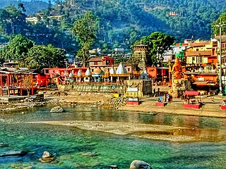
Yamunotri, also Jamnotri, is the source of the Yamuna River and the seat of the Goddess Yamuna in Hinduism. It is situated at an altitude of 3,293 metres (10,804 ft) in the Garhwal Himalayas and located approximately 150 kilometres (93 mi) North of Uttarkashi, the headquarters of the Uttarkashi district in the Garhwal Division of Uttarakhand, India. It is one of the four sites in India's Chota Char Dham pilgrimage. The sacred shrine of Yamunotri, source of the river Yamuna, is the westernmost shrine in the Garhwal Himalayas, perched atop a flank of the Bandarpunch mountain. The chief attraction at Yamunotri is the temple devoted to the Goddess Yamuna and the holy thermal springs at Janki Chatti which is 7 km away.

Almora is a district in the Kumaon Division of Uttarakhand state, India. The headquarters is at Almora. It is 1,638 meters above sea level. The neighbouring regions are Pithoragarh district to the east, Chamoli district to the west, Bageshwar district to the north and Nainital district to the south.
Milam Glacier is a major glacier of the Kumaon Himalaya.

Pindari Kanda Traill's Pass is a mountain pass through the Himalayas located between Nanda Devi and Nanda Kot peaks in the Uttarakhand state in the districts of Pithoragarh and Bageshwar in India.
Bageshwar is a town and a municipal board in Bageshwar district in the state of Uttarakhand, India. It is located at a distance of 470 km from the National Capital New Delhi and 332 km from the State Capital Dehradun. Bageshwar is known for its scenic environment, glaciers, rivers and temples. It is also the administrative headquarters of Bageshwar district.
Kausani is a hill station and Village situated in Bageshwar district in the state of Uttarakhand, India. It is famous for its scenic splendour and its spectacular 300 km-wide panoramic view of Himalayan peaks like Trisul, Nanda Devi and Panchchuli. Mahatma Gandhi called this place the 'Switzerland of India', due to similarity in landscapes.

Baijnath is a small town on the banks of the Gomati river in the Bageshwar district in Kumaon division of Uttarakhand, India. The place is most noted for its ancient temples, which have been recognized as Monuments of National Importance by the Archaeological Survey of India in Uttarakhand. Baijnath has been selected as one of the four places to be connected by the 'Shiva Heritage Circuit' in Kumaon, under the Swadesh Darshan Scheme of the Government of India.

Trisul is a group of three Himalayan mountain peaks of western Kumaun, Uttarakhand, with the highest reaching 7120m. The three peaks resemble a trident - in Sanskrit, Trishula, trident, is the weapon of Shiva. The Trishul group forms the southwest corner of the ring of peaks enclosing the Nanda Devi Sanctuary, about 15 kilometres (9 mi) west-southwest of Nanda Devi itself. The main peak, Trisul I, was the first peak over 7,000 m (22,970 ft) to have ever been climbed, in 1907.
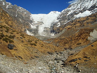
The Kafni Glacier is located in the upper reaches of the Kumaon Himalayas, to the southeast of Nanda Devi. The glacier gives rise to the Kafni River, which is a tributary of the Pindar River. The Pindar River is a tributary to Alaknanda River, which eventually is one of the two headstreams of the Ganges. This is relatively small glacier but a popular trekking destination along with Pindari Glacier.

Naukuchiatal or "lake of nine corners" is a small hill station, near Nainital Town in Nainital district of Kumaon, Uttarakhand, India. The chairman is Devendra Singh chanotiya.
Uttarakhand is a state in the northern part of India. It is often referred to as the "Devbhumi" due to its religious significance and numerous Hindu temples and pilgrimage sites found throughout the state. As a result, religious tourism forms a major portion of the tourism in the state. Uttarakhand is known for the natural environment of the Himalayas. 2019 Tourist Arrivals Domestic – 40,000,000 per/year and Foreigner – 150,000 per year. Tourism business in Uttarakhand generated ₹ 23,000 crores during 2013–14.
Kapkot or Kapkote is a village in Bageshwar district, Uttarakhand, India. It houses the headquarters of Kapkot Tehsil, the largest administrative subdivision of Bageshwar district. It is known for being the last bus terminus on the route to Pindari Glacier. Kapkot is located almost 25 kilometres (16 mi) from its district headquarters at Bageshwar.
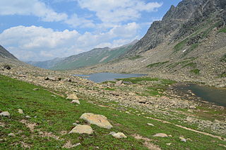
The Satsar Lake or Sat Sar consists of seven small alpine lakes situated in Ganderbal district of the Kashmir Valley in Jammu and Kashmir, India.

Kasar Devi is a village near Almora, Uttarakhand. It is known for the Kasar Devi temple, a Devi temple, dedicated to Kasar Devi, after whom the place is also named. The temple structure dates to the 2nd century CE. Swami Vivekananda visited Kasar Devi in 1890s, and numerous western seeker, Sunyata Baba Alfred Sorensen and Lama Anagarika Govinda.

The Sarju, also known as Sarayu, is a major river draining Central Kumaon region in the Indian state of Uttarakhand. Originating from Sarmul, Sarju flows through the cities of Kapkot, Bageshwar and Seraghat before joining Mahakali at Pancheshwar. The Sarju is the largest tributary of the Sharda River. The river forms the South-eastern border between the districts of Pithoragarh and Almora. Temperate and sub-Tropical forests cover the entire Catchment area of the River.
Mankot is a Village situated in Bageshwar district in the State of Uttarakhand, India. It is located at a distance of 13.5 kilometres (8.4 mi) from Bageshwar on the National Highway 309A. Mankot is a medium-sized village with total 118 families residing.

Panwali Dwar is a mountain of the Kumaun Himalayas located in the Bageshwar district of Uttarakhand, India. The elevation of Panwali Dwar is 6,683 metres (21,926 ft) and its prominence is 763 metres (2,503 ft). It is 55th highest located entirely within the Uttarakhand. Nanda Devi, is the highest mountain in this category. It lies on southern wall of Nanda devi sanctuary. Its nearest higher neighbor Maiktoli 6,803 metres (22,320 ft) lies 8.2 km WSW. It is located 2.6 km SW of Nanda Khat 6,611 metres (21,690 ft) and 9.2 km NE lies Nanda Devi East 7,434 metres (24,390 ft).

Badhangarhi temple is an ancient Hindu temple dedicated to Kali, worshipped as Maa Dakshineshwar kaali or Bhagwati. People living in Tharali, Naranbagar, Dewal block of Chamoli and garur, kapkot block of Bageshwar have a great faith in Badhangarhi, a popular deity in this region. It is situated in Tharali tehsil of Chamoli Garhwal district of Uttarakhand. The nearest town to Badhangarhi is Gwaldam which is 8 km from the main Badhangarhi temple. The temple is situated at the elevation of about 2260 m.


