
Pithoragarh district is the easternmost district in the state of Uttarakhand. It is located in the Himalayas and has an area of 7,110 km2 (2,750 sq mi) and a population of 483,439. The city of Pithoragarh, located in Saur Valley, is its headquarters. The district is within the Kumaon division of Uttarakhand state. The Tibet plateau is situated to the north and Nepal is to the east. The Kali River which originates from the Kalagiri Mountain flows south, forming the eastern border with Nepal. The Hindu pilgrimage route for Mount Kailash-Lake Manasarovar passes through this district via Lipulekh Pass in the greater Himalayas. The district is administratively divided into six Tehsils: Munsyari; Dharchula; Didihat; Berinag; Gangolihat; and Pithoragarh. Naini Saini Airport is the nearest civil airport, but it does not have a regular scheduled commercial passenger service. The mineral deposits present in the district are magnesium ore, copper ore, limestone, and slate. There are 11 tehsils.
Milam Glacier is a major glacier of the Kumaon Himalaya.

Munsiyari is the name of the sub-division headquarters, a conglomeration of revenue villages and it also refers to the entire region as Munsiyari Tehsil and Sub Division in the Pithoragarh District in the hill-state of Uttarakhand, India.
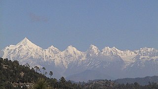
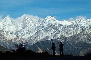
Saur Valley is a small valley, 8 km (5.0 mi) long and 5 km (3.1 mi) wide, which resembles Kashmir Valley, located in Pithoragarh district of Uttarakhand state of India. Pithoragarh town is situated in this valley. The valley is surrounded by beautiful mountains, slopes gently to the south-east, and is bisected into north and south by a tubular ridge of slate, limestone and greenstone originating in the mountains to the north-west and branching down to the south-east. The altitude is 1,650 m (5,410 ft) above sea level. One can have panoramic views of the vast snow range extending across Trishuli, Nanda Devi, Panchchuli Group, and Api of Nepal from the place named Chandak, located on a nearby 2,000 m (6,600 ft) hill. Most Manu, near Chandak, hosts an annual fair.
The Panchachuli (पंचाचुली) peaks are a group of five snow-capped Himalayan peaks lying at the end of the eastern Kumaon region, near the Dugtu village in Darma valley. The peaks have altitudes ranging from 6,334 metres (20,781 ft) to 6,904 metres (22,651 ft). They form the watershed between the Gori and the Darmaganga valleys. Panchachuli is also located on the Gori Ganga-Lassar Yankti divide. The group lies 138 km (86 mi) from Pithoragarh. The first ascent of this range was done by an Indo-Tibetan Border Police (ITBP) team in 1972, via the Uttari Balati glacier, led by Major Hukam Singh.
Askot Musk Deer Sanctuary is located 54 km (34 mi) from Pithoragarh near Askot in Uttarakhand state of India. This sanctuary has been set up primarily with the object of conserving the musk deer (Moschus leucogaster) and its habitat. Intensive efforts have been initiated to conserve this rare species. Other mammals found in this sanctuary include the Bengal tiger, Indian leopard, Himalayan jungle cat, civet, barking deer, serow, goral and Himalayan brown bear. Many species of high altitude birds are also found in this sanctuary.
Rajrambha is the name of a Himalayan mountain peak, situated in the Pithoragarh district of Uttarakhand state of India. It means 'celestial nymph' (Apsara) in Hindi. This peak is situated south of the Kalabaland Glacier in eastern Kumaun in the Ralam valley. The summit of the peak is 6,537 m. The nearby peaks which form the north-south massif are Suitilla 6,373 m, Chaudhara 6,510 m, and Ngalaphu 6,410 m.
Kalabaland Glacier of Himalaya is situated in the eastern Kumaun of the Pithoragarh district of Uttarakhand state of India.
Sin La is a high Himalayan mountain pass located in the eastern Kumaon in Pithoragarh District of Uttarakhand state in India.
Darma valley is a Himalayan valley situated in the Pithoragarh District of Uttarakhand state of India. This valley is located in the eastern part of Uttarakhand at Kumaon division.
Chaudhara is a Himalayan mountain peak, situated in the Pithoragarh district of Kumaon, India. The altitude of the peak is 6,510 m. The peak lies to the south of Ralam pass and north west of Panchchuli. The peak is so named due to the peak having four corners. The peak was climbed for the first time by an Indian team led by A.R.Chandekar and Sherpa Ajeeba in 1973. Rajrambha is its neighbouring peak. Chaudhara is situated at the south east end of Kalabaland Glacier-Sankalp Glacier-Yangchar Glacier group. Chaudhara is the part of Himalayan massif between Ralam and Lassar valley. The most popular route to the summit is via the west face.
Nagalaphu is a Himalayan mountain peak located in the Pithoragarh district of Uttarakhand state in India.
Meola Glacier or Athasi-Balati Glacier is the Himalayan glacier situated in the eastern part of Uttarakhand in the Pithoragarh district of India.
Suj Tilla or Suitilla is a Himalayan peak located on the eastern side of Uttarakhand state in Pithoragarh District of India. The peak is located above the junction of Kalabaland, Sankalp and Yankchar glaciers. Ralam Dhura pass is situated to the south of this peak, which connects Ralam valley to Darma valley.
Sona Glacier is the Himalayan glacier situated in the eastern part of Uttarakhand in the Pithoragarh district of India.
Rishi Pahar is a Himalayan mountain peak, located in the Pithoragarh district of Uttarakhand state in India. It lies at the northeast corner of the ring of peaks surrounding the Nanda Devi Sanctuary, and on the eastern rim of the Nanda Devi Biosphere Reserve, just south of Trishuli and Hardeol. The Milam Glacier lies on its east flank. It marks the triple divide between the Milam, Dunagiri, and Uttari Rishi Ganga valleys. Rishi Pahar means 'The Peak of Saint' in Hindi.
Suj Tilla East is a Himalayan mountain peak in the eastern part of Uttarakhand state in Pithoragarh district of India. The peak is located above the junction of Kalabaland, Sankalp and Yankchar glaciers. Ralam Dhura pass is situated to the south of this peak, which connects Ralam valley to Darma valley. This peak is characterised by steep ice-flutings and sharp ridges, so named as 'Peak of needles'. This peak has not been climbed so far. The most popular route to the summit is through the south west face. Suj Tilla East is situated 200 m away from Suj Tilla West. Suj Tilla East is 21 m higher than Suj Tilla West. This peak is still an unclimbed peak due to sharp cornices and icefalls on the ridge.

Berinag is a hill station, located 124 km from Pithoragarh city in the Pithoragarh district, which is the easternmost Himalayan district in the state of Uttarakhand, India. It is one of the six Administrative Subdivisions (tehsil) of Pithoragarh district. National Highway 309A passes through Berinag. Closest prominent villages include Garawon, Dhanoli, Bana, Bhattigaon, Banoli, Quarali, Tripuradevi and Sangarh.

Gori Ganga is a river in the Munsiari tehsil of the Pithoragarh District, part of the state of Uttarakhand in northern India. Its principal source is the Milam Glacier, just northeast of Nanda Devi along with the Glaciers of the Ralam River, and the Pyunshani and Uttari & Dakshini Balati Glaciers that lie on the western face of the Panchachuli Peaks.
Johar Valley is a valley located in Pithoragarh district of Uttarakhand, India, along the Gori Ganga river. The valley used to be a major trade route with Tibet. The best known villages in the valley are Martoli and Milam.


