


The Dhauliganga is a turbulent Himalayan river which rises in the border regions of India and China and flows south into the Garhwal region of Uttarakhand, India. It joins the Alaknanda, the major source stream of the Ganges river.
The Dhauliganga is a turbulent Himalayan river which rises in the border regions of India and China and flows south into the Garhwal region of Uttarakhand, India. It joins the Alaknanda, the major source stream of the Ganges river.
Dhauliganga rises in the vicinity of the Niti Pass in the border regions between Garhwal and southwestern Tibet. [1] It flows 50 km (30 mi) southwards until it meets the Rishiganga on its left bank at Rini, in the vicinity of Tapovan in Chamoli district. It then flows 20 km (10 mi) westwards until it meets the Alaknanda at Vishnuprayag and terminates—the confluence just upstream of the city of Joshimath. [1] The upper Dhauliganga valley parts the East-West Himalayan axis, with Nanda Devi and its subsidiary peaks to its left and Kamet and its subsidiary peaks to its right. [1]
On 7 February 2021, part of Nanda Devi Glacier, a Himalayan glacier in the Nanda Devi National Park, broke away and caused water levels in the Rishiganga and Dhauliganga rivers to rise. The Dhauliganga Dam at the Dhauliganga hydropower project at Reni village ( 30°29′06″N79°41′28″E / 30.485°N 79.691°E ) was destroyed and another suffered partial collapse. Initial reports said nine people were killed and 140 missing. Water levels on the Alaknanda also rose. [2] [3]

Nanda Devi is the second-highest mountain in India, after Kangchenjunga, and the highest located entirely within the country. Nanda Devi is the 23rd-highest peak in the world.

Chamoli district is a district of the Uttarakhand state of India. It is bounded by the Tibet region to the north, and by the Uttarakhand districts of Pithoragarh and Bageshwar to the east, Almora to the south, Pauri Garhwal to the southwest, Rudraprayag to the west, and Uttarkashi to the northwest. The administrative headquarters of Chamoli district is in Gopeshwar.

The Alaknanda is a turbulent Himalayan river in the Indian state of Uttarakhand and one of the two headstreams of the Ganges, the major river of Northern India and a river considered holy in Hinduism. In hydrology, the Alaknanda is considered the source stream of the Ganges on account of its greater length and discharge; while, in Hindu tradition and culture, the other headstream, the Bhagirathi, is considered the source stream.

Panch Prayag is an expression in Hindu religious ethos, specifically used to connote the five sacred river confluences in the Garhwal Himalayas in the state of Uttarakhand, India. The five prayags - prayaga meaning "place of confluence of rivers" in Sanskrit - also termed as "Prayag pentad" are Vishnuprayag, Nandaprayag, Karnaprayag, Rudraprayag and Devprayag, in the descending flow sequence of their occurrence.
Deoban is a mountain of Garhwal Himalaya in Uttarakhand, India. Deoban stands at 6855 meter 22490 feet. Its joint 28th highest located entirely within the uttrakhand India. Nanda Devi, is the highest mountain in this category. Deoban is the 396th highest peak in the world. Deoban located just south east of Mana Peak and west of Bidhan. on the south west side lies the Mandir Parbat.

Mrigthuni is a mountain of Kumaon Himalaya in Uttarakhand, India. Mrigthuni standing majestically at 6855 meter 22,490 feet. Its joint 28th highest located entirely within the Uttarakhand, India. Nanda Devi is the highest mountain in this category. It is the 394th highest peak in the world. It is located at the southern rim of Nanda Devi Sanctuary. It is located just west of Devtoli 6788 meter and north west of Trisul 7120 meter. on the northeast side lies the mighty Nanda Devi 7816 meter and Devistan 6678 meter. on the southern side lies Tharkot 6099 meter.

Maiktoli is a mountain of Kumaun Himalayas located in the Bageshwar district of Uttarakhand state in India. It stands at 6,803 metres (22,320 ft). It is jointly the 32nd highest located entirely within the uttrakhand India. Nanda Devi is the highest mountain in this category. Maiktoli is 479th highest peak in the world. It is located at the southern rim of Nanda Devi Sanctuary. Maiktoli is located just south east of Devtoli and south east of Trisul. On the north east side lies Nanda Devi and Panwali Dwar. On the south west side lies Tharkot.

Devtoli is a mountain of Kumaon Himalaya located in the Bageshwar district of Uttarakhand,India. It stands at 6,788 metres (22,270 ft). It is 36th highest located entirely within Uttarakhand. Nanda Devi is the highest mountain in this category. It is located at the southern rim of Nanda Devi Sanctuary. Devtoli is located just north west of Maiktoli and east of Mrigthuni. On the north east side lies Nanda Devi and Panwali Dwar on the east side. Tharkot on the southern side.
Bidhan Parbat is a mountain of the northern Garhwal Himalaya in Uttarakhand India.The elevation of Bidhan Parbat is 6,520 metres (21,391 ft) and its prominence is 234 metres (768 ft). It is 84th highest located entirely within the Uttrakhand. Nanda Devi, is the highest mountain in this category. It is situated in the Zaskar Range. It lies 3 km west of Deoban 6,855 metres (22,490 ft) its nearest higher neighbor. Mandir Parbat 6,559 metres (21,519 ft) lies 8.3 km SW and it is 10.4 km SE of Kamet 7,756 metres (25,446 ft). It lies 6.6 km SE of Mana Peak 7,272 metres (23,858 ft).
Sakram is a mountain of the Garhwal Himalaya in Uttarakhand India. It's situated on the eastern rim of Nanda Devi Sanctuary on the watershed of Milam Glacier and Nanda Devi basin. The elevation of Sakram is 6,254 metres (20,518 ft) and its prominence is 134 metres (440 ft). It is 129th highest located entirely within the Uttrakhand. Nanda Devi, is the highest mountain in this category. It lies 1.2 km SSW of Lohar Deo 6,267 metres (20,561 ft) its nearest higher neighbor and 3.3 km SSE of Deo Damla 6,620 metres (21,719 ft). Kalanka 6,931 metres (22,740 ft) lies 11.9 km NNW and 8.7 km SW lies Nanda Devi 7,816 metres (25,643 ft).
Bamchu is a mountain of the Garhwal Himalaya in Uttarakhand India. It's situated on the eastern rim of Nanda Devi Sanctuary on the watershed of Milam Glacier and Nanda Devi basin. The elevation of Bamchu is 6,303 metres (20,679 ft) and its prominence is 241 metres (791 ft). It is 124th highest located entirely within the Uttrakhand. Nanda Devi, is the highest mountain in this category. It lies 3.4 km South of Deo Damla 6,620 metres (21,719 ft) its nearest higher neighbor and 3.1 km SSE of Mangraon 6,568 metres (21,549 ft). Kalanka 6,931 metres (22,740 ft) lies 9.8 km NNW and 9.3 km SW lies Nanda Devi 7,816 metres (25,643 ft).
Deo Damla is a mountain of the Garhwal Himalaya in Uttarakhand, India. It is situated in the eastern rim of Nanda Devi Sanctuary on the watershed of Milam Glacier and Nanda Devi basin. The elevation of Deo Damla is 6,620 metres (21,719 ft) and its prominence is 693 metres (2,274 ft). It is 63rd highest located entirely within the Uttrakhand. Nanda Devi, is the highest mountain in this category. It lies 1.8 km SSE of Mangraon 6,568 metres (21,549 ft). Its nearest higher neighbor Rishi Pahar 6,992 metres (22,940 ft) lies 8.3 km NNW and it is 10.6 km SSW of Nanda Devi 7,816 metres (25,643 ft). It lies 1.4 km north of Bamchu 6,303 metres (20,679 ft).
Mangraon is a mountain of the Garhwal Himalaya in Uttarakhand India. It is situated in the eastern rim of Nanda Devi Sanctuary on the watershed of Milam Glacier and Nanda Devi basin. The elevation of Mangraon is 6,568 metres (21,549 ft) and its prominence is 563 metres (1,847 ft). It is joint 71st highest located entirely within the Uttrakhand. Nanda Devi, is the highest mountain in this category. It lies 1.8 km SSE of Deo Damla 6,568 metres (21,549 ft) its nearest higher neighbor. Rishi Pahar 6,992 metres (22,940 ft) lies 6.5 km North and it is 11.8 km NNE of Nanda Devi 7,816 metres (25,643 ft). It lies 9.5 km north of Lhatu Dhura 6,387 metres (20,955 ft).
Lhatu Dhura is a mountain of the Garhwal Himalaya in Uttarakhand, India. It is situated in the eastern rim of the Nanda Devi Sanctuary, on the watershed of the Milam Glacier and the Nanda Devi basin. The elevation of Lhatu Dhura is 6,392 metres (20,971 ft) and its prominence is 229 metres (751 ft). It is joint 103rd highest mountain located entirely within Uttrakhand. It lies 4.6 km south of Sakram 6,254 metres (20,518 ft). Its nearest higher neighbor Nanda Devi East lies 4.5 km to the south west, and Deo Damla lies 7.7 km to the north; it is 6.1 km east-north-east of Nanda Devi, and 9.5 km south of Mangraon.
Lohar Deo is a mountain of the Garhwal Himalaya in Uttarakhand, India. It is situated in the eastern rim of Nanda Devi Sanctuary on the watershed of Milam Glacier and Nanda Devi basin. The elevation of Lohar Deo is 6,245 metres (20,489 ft) and its prominence is 222 metres (728 ft). It is joint 133rd highest located entirely within the Uttrakhand. Nanda Devi, is the highest mountain in this category. Lohar Deo situated between Sakram in the south west and Bamchu on the north west. It lies 1.2 km NNE of Sakram 6,254 metres (20,518 ft). Its nearest higher neighbor Deo Damla 6,620 metres (21,719 ft) lies 2.6 km NW. Bamchu 6,303 metres (20,679 ft) lies 1.8 km NW and it is 9.9 km NE of Nanda Devi 7,816 metres (25,643 ft). It lies 11.6 km SE of Kalanka 6,931 metres (22,740 ft).
Durpata is a mountain of the Garhwal Himalaya in Uttarakhand India. It is situated in the Kamet range. The elevation of Durpata is 6,468 metres (21,220 ft) and its prominence is 638 metres (2,093 ft). It is 93rd highest located entirely within the Uttrakhand. Nanda Devi, is the highest mountain in this category. It lies 3.8 km east of Gauri Parbat 6,708 metres (22,008 ft) its nearest higher neighbor. Hathi Parbat 6,727 metres (22,070 ft) lies 4.8 km SW and it is 5.1 km SSE of Rataban 6,166 metres (20,230 ft). It lies 11.7 km SSE of Nilgiri Parbat 6,474 metres (21,240 ft).
Gorur Parbat is a mountain of the Garhwal Himalaya in Uttarakhand India. It is situated just outside of the northern rim of Nanda Devi Sanctuary. The elevation of Gorur Parbat is 6,504 metres (21,339 ft) and its prominence is 577 metres (1,893 ft). It is joint 88th highest located entirely within the Uttrakhand. Nanda Devi, is the highest mountain in this category. It lies 3.1 km SSE of Lampak I 6,325 metres (20,751 ft). Rishi Pahar 6,992 metres (22,940 ft) lies 8.6 km SSE and it is 6.6 km NNW of Hardeol 7,151 metres (23,461 ft). It lies 4.5 km NW of Tirsuli West 7,035 metres (23,081 ft).

The 2021 Uttarakhand flood, also known as the Chamoli disaster, began on 7 February 2021 in the environs of the Nanda Devi National Park, a UNESCO World Heritage Site in the outer Garhwal Himalayas in Uttarakhand state, India. It was caused by a large rock and ice avalanche consisting of material dislodged from Ronti peak. It caused flooding in the Chamoli district, most notably in the Rishiganga river, the Dhauliganga river, and in turn the Alaknanda—the major headstream of the Ganges. The disaster left over 200 killed or missing. Most were workers at the Tapovan dam site.
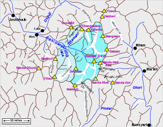
Rishiganga is a river in the Chamoli district, Uttarakhand, India. It springs from the Uttari Nanda Devi Glacier on the Nanda Devi mountain. It is also fed from the Dakshini Nanda Devi Glacier. Continuing through the Nanda Devi National Park, it flows into the Dhauliganga River near the village Rini.
Raini is a village in Chamoli district in Uttarakhand, north India. Rini is located on the river banks at the confluence of Rishi Ganga and Dhauli Ganga rivers.
From the Mana pass, about 50 km eastwards as a crow flies, is located Niti pass. The Dhauli Ganga rises here, and flowing first southwards, then westwards, joins the Alaknanda at Vishnu Prayag, just upstream from the township of Joshimath. Three large settlements. Bampa, Gamshali, and Niti, are situated on the upper reaches of Dhauli, and are inhabited by a group of Bhotias who are also Marchhas, though culturally and linguistically they are not identical to the Marchhas of Mana
30°33′43″N79°34′34″E / 30.562°N 79.576°E