Nanda Devi Glacier

Last updated
Nanda Devi Glacier
Map, Uttari Nanda Devi Glacier.jpg
Nanda Devi Glacier
India Uttarakhand relief map.svg
Red pog.svg
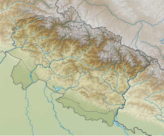
Location of Nanda Devi Glacier, in Uttarakhand
India relief location map.jpg
Red pog.svg
Nanda Devi Glacier (India)
Location Himalayas, India
Coordinates 30°24′45.22″N79°58′58.26″E / 30.4125611°N 79.9828500°E / 30.4125611; 79.9828500 Coordinates: 30°24′45.22″N79°58′58.26″E / 30.4125611°N 79.9828500°E / 30.4125611; 79.9828500
Nanda Devi Glacier

Nanda Devi Glacier is a glacier in Chamoli district, [1] Uttarakhand, India. It is near Nanda Devi.

Contents

The Nanda Devi Group of glaciers is a reference to the cluster of seven glaciers namely Bartoli, Kururntoli, Nada Devi North, Nanda Devi South, Nandakna, Ramani and Trsul of Uttarakhand. [2]

The glacier rose to fame, due to its breaking, which led to the 2021 Uttarakhand flood. Climate change has been suggested to have contributed to the disaster. [3]

See also

Related Research Articles

Nanda Devi Second-highest mountain in India

Nanda Devi is the second-highest mountain in India, after Kangchenjunga, and the highest located entirely within the country. It is the 23rd-highest peak in the world.

Kedarnath Town in Uttarakhand, India

Kedarnath is a town in Rudraprayag district in the state of Uttarakhand in India and has gained importance because of the Kedarnath Temple. It is approximately 86 kilometres from Rudraprayag, the district headquarter. It is a Nagar panchayat in the Rudraprayag district. Kedarnath is the most remote of the four Chota Char Dham pilgrimage sites. It is located in the Himalayas, about 3,583 m (11,755 ft) above sea level near the Chorabari Glacier, which is the source of the Mandakini river. The town is flanked by snow-capped peaks, most prominently the Kedarnath Mountain. The nearest road head is at Gaurikund about 16 km away. The town suffered extensive destruction during June 2013 from the Flash Floods caused by torrential rains in Uttarakhand state.

Joshimath City in Uttarakhand, India

Joshimath, also known as Jyotirmath, is a city and a municipal board in Chamoli District in the Indian state of Uttarakhand. Located at a height of 6150 feet, it is a gateway to several Himalayan mountain climbing expeditions, trekking trails and pilgrim centres like Badrinath. It is home to one of the four cardinal pīthas established by Adi Shankara. Since 7 February 2021, the area was severely efected by the 2021 Uttarakhand flood and its aftermath.

Chamoli district District of Uttarakhand in India

Chamoli district is a district of the Uttarakhand state of India. It is bounded by the Tibet region to the north, and by the Uttarakhand districts of Pithoragarh and Bageshwar to the east, Almora to the south, Pauri Garhwal to the southwest, Rudraprayag to the west, and Uttarkashi to the northwest. The administrative headquarters of Chamoli district is in Gopeshwar.

Roopkund Lake in Uttarakhand, India

Roopkund is a high altitude glacial lake in the Uttarakhand state of India. It lies in the lap of Trishul massif. Located in the Himalayas, the area around the lake is uninhabited and is roughly at an altitude of 5,020 metres (16,470 ft), surrounded by rock-strewn glaciers and snow-clad mountains. Roopkund is a popular trekking destination. The size of the lake varies substantially, but it is seldom more than 40 metres in diameter, and is frozen in the winter.

Milam Glacier is a major glacier of the Kumaon Himalaya.

Traills Pass

Pindari Kanda Traill's Pass is a mountain pass through the Himalayas located between Nanda Devi and Nanda Kot peaks in the Uttarakhand state in the districts of Pithoragarh and Bageshwar in India.

The Nanda Devi National Park or Nanda Devi Biosphere Reserve, established in 1982 is a national park situated around the peak of Nanda Devi in Chamoli Garhwal district of Uttarakhand, in northern India. The entire park lies at an elevation of more than 3,500 m (11,500 ft) above mean sea level.

Mandakini River River in India

The Mandakini River is a tributary of the Alaknanda River in the Indian state of Uttarakhand. The river runs for approximately 81 kilometres (50 mi) between the Rudraprayag and Sonprayag areas and emerges from the Chorabari Glacier. The river merges with river Songanga at Sonprayag and flows past the Hindu temple Madhyamaheshwar at Ukhimath. At the end of its course it drains into the Alaknada, which flows into the Ganges.

Dhauliganga River River in Uttarakhand, India

The Dhauliganga is a turbulent Himalayan river which rises in the border regions of India and China and flows south into the Garhwal region of Uttarakhand, India. It joins the Alaknanda, the major source stream of the Ganges river.

Geography of Uttarakhand

Uttarakhand has a total geographical area of 53,483 km2, of which 86% is mountainous and 65% is covered by forest. Most of the northern parts of the state are part of Greater Himalayan ranges also known as Himadri, covered by the high Himalayan peaks and glaciers, while the lower foothills were densely forested till denuded by the British log merchants and later, after independence, by forest contractors. Recent efforts in afforestation, however, have been successful in restoring the situation to some extent. The unique Himalayan ecosystem plays host to many animals, plants and rare herbs. Two of the India's great rivers, the Ganges and the Yamuna take birth in the glaciers of Uttarakhand state, and are fed by myriad lakes, glacial melts and streams. It is fed by Ganges and Yamuna rivers.

Uttarakhand is a state in the northern part of India. It is often referred to as the "Devbhumi" due to its religious significance and numerous Hindu temples and pilgrimage sites found throughout the state. As a result, religious tourism forms a major portion of the tourism in the state. Uttarakhand is known for the natural environment of the Himalayas. 2019 Tourist Arrivals Domestic - 40,000,000 per/year and Foreigner - 150,000 per year. Tourism business in Uttarakhand generated 23,000 crores during 2013-14.

Sunanda Devi

Nanda Devi East, locally known as Sunanda Devi, is the lower of the two adjacent peaks of the highest mountain in Uttarakhand and second highest mountain in India; Nanda Devi is its higher twin peak. Nanda Devi and Nanda Devi East are part of the Garhwal Himalayas, and are located in the state of Uttarakhand. The graceful peaks of twin mountains are visible from almost everywhere in Kumaon. The first ascent to Nanda Devi East peak in recorded history appears to be in 1939 by Jakub Bujak and Janusz Klarner. The elevation of Nanda Devi East is 7,434 m (24,390 ft) and its prominence is 260 m (850 ft).

Kalanka Mountain in Garhwal Himalaya

Kalanka is a mountain of Garhwal Himalaya in Uttarakhand, India. Kalanka stands at 6931 meter 22740 feet. It's the 20th highest located entirely within the Uttrakhand. Nanda Devi is the highest mountain in this category. Kalanka is the 48th highest peak in India and 319th highest peak in the world. Southern side of Kalanka is falls under Nanda Devi National Park.

Mrigthuni

Mrigthuni is a mountain of Kumaon Himalaya in Uttarakhand, India. Mrigthuni standing majestically at 6855 meter 22,490 feet. Its joint 28th highest located entirely within the Uttarakhand, India. Nanda Devi is the highest mountain in this category. It is the 394th highest peak in the world. It is located at the southern rim of Nanda Devi Sanctuary. It is located just west of Devtoli 6788 meter and north west of Trisul 7120 meter. on the northeast side lies the mighty Nanda Devi 7816 meter and Devistan 6678 meter. on the southern side lies Tharkot 6099 meter.

2021 Uttarakhand flood Flood in Uttarakhand, India, February 2021

The 2021 Uttarakhand flood, also known as the Chamoli disaster, began on 7 February 2021 in the environs of the Nanda Devi National Park, a UNESCO World Heritage Site in the outer Garhwal Himalayas in Uttarakhand state, India. It was caused by a large rock and ice avalanche consisting of material dislodged from Ronti peak. It caused flooding in the Chamoli district, most notably in the Rishiganga river, the Dhauliganga river, and in turn the Alaknanda—the major headstream of the Ganges. The disaster left over 200 killed or missing. Most were workers at the Tapovan dam site.

Dakshini Nanda Devi Glacier is a glacier in Chamoli district, Uttarakhand, India. With Uttari Nanda Devi Glacier, Dakshini Nanda Devi Glacier flanks Nanda Devi peak and also feeds the Rishiganga river. Nanda Khat is also near.

Rishiganga River in Uttarakhand, India

Rishiganga is a river in the Chamoli district, Uttarakhand, India. It springs from the Uttari Nanda Devi Glacier on the Nanda Devi mountain. It is also fed from the Dakshini Nanda Devi Glacier. Continuing through the Nanda Devi National Park, it flows into the Dhauliganga River near the village Rini.

Rini, Uttarakhand Village in Uttarakhand, India

Rini is a village in Chamoli district in Uttarakhand, north India. Rini is located on the river banks at the confluence of Rishi Ganga and Dhauli Ganga rivers.

The Nanda Devi Plutonium Mission was a joint operation by the United States Central Intelligence Agency and the Indian Intelligence Bureau to spy on the nuclear developments being conducted in the Xinjiang Province of China. The agencies cooperated in October 1965 to install a nuclear-powered remote sensing station on the peak of Nanda Devi in the Uttarakhand Garhwal Himalayas.

References

  1. "Nanda Devi glacier burst: What we know so far". February 7, 2021. Retrieved 2021-02-13.
  2. "Nanda Devi Group of Glaciers".
  3. "Climate Crisis Likely Behind Deadly Glacier Collapse in India".