
Nanda Devi is the second-highest mountain in India, after Kangchenjunga, and the highest located entirely within the country. It is the 23rd-highest peak in the world.
Oropolitics comes from the Greek oros meaning mountain and politikos meaning citizen. In modern usage it denotes the use of mountaineering for political purposes.
The Nanda Devi National Park or Nanda Devi Biosphere Reserve, established in 1982 is a national park situated around the peak of Nanda Devi in Chamoli Garhwal district of Uttarakhand, in northern India. The entire park lies at an elevation of more than 3,500 m (11,500 ft) above mean sea level.

Ladakh is an administrative territory of India that has been under its control since 1947. The geographical region of Ladakh union territory is the highest altitude plateau region in India, incorporating parts of the Himalayan and Karakoram mountain ranges and the upper Indus River and valley.

Gori Ganga is a river in the Munsiari tehsil of the Pithoragarh District, part of the state of Uttarakhand in northern India. Its principal source is the Milam Glacier, just northeast of Nanda Devi along with the Glaciers of the Ralam River, and the Pyunshani and Uttari & Dakshini Balati Glaciers that lie on the western face of the Panchachuli Peaks.

Bara Shigri is a glacier located in Lahaul & Spiti, Himachal Pradesh, India. It is currently extending to 27.7 kilometres and covers over 126.45 square kilometres. It is the largest glacier in Himachal Pradesh.

The Garhwal Himalayas are mountain ranges located in the Indian state of Uttarakhand.
Colonel Narendra Kumar, PVSM, KC, AVSM, FRGS was an Indian soldier and mountaineer. He is known for his expeditions across various mountain ranges such as the Himalayas and Karakorams, and respective subranges such as the Pir Panjals and Saltoro Mountains. His reconnaissance efforts on the Siachen glacier were key to the Indian Army's reclamation of the forward posts of the glacier in Operation Meghdoot in 1984. He was the deputy leader of the first successful Indian Mount Everest expedition in 1965.

Kalanka is a mountain of Garhwal Himalaya in Uttarakhand, India. Kalanka stands at 6931 meter 22740 feet. It's the 20th highest located entirely within the Uttrakhand. Nanda Devi is the highest mountain in this category. Kalanka is the 48th highest peak in India and 319th highest peak in the world. Southern side of Kalanka is falls under Nanda Devi National Park.
Saf Minal is a mountain of Garhwal Himalaya in Uttarakhand India. Saf Minal standing majestically at 6911 meter 22674 feet. It's the 21st highest located entirely within the uttrakhand India. Nanda Devi, is the highest mountain in this category and 50th highest peak in India. Saf Minal is the 332nd highest peak in the world. Saf Minal falls on the edge of the Northern Nanda Devi National Park.

Maiktoli is a mountain of Kumaun Himalayas located in the Bageshwar district of Uttarakhand state in India. It stands at 6,803 metres (22,320 ft). It is jointly the 32nd highest located entirely within the uttrakhand India. Nanda Devi is the highest mountain in this category. Maiktoli is 479th highest peak in the world. It is located at the southern rim of Nanda Devi Sanctuary. Maiktoli is located just south east of Devtoli and south east of Trisul. On the north east side lies Nanda Devi and Panwali Dwar. On the south west side lies Tharkot.
Saraswati Parbat II is a mountain of the Garhwal Himalaya in Uttarakhand India.The elevation of Saraswati Parbat II is 6,775 metres (22,228 ft) and its prominence is 551 metres (1,808 ft). It is 37th highest located entirely within the Uttrakhand. Nanda Devi, is the highest mountain in this category. It falls under Kamet Zaskar Range. It lies between Saraswati Parbat I and Chamrao Parbat I It lies 3.1 km NNW of Chamrao Parbat I 6,910 metres (22,671 ft). Its nearest higher neighbor Saraswati Parbat I 6,940 metres (22,769 ft). It is located 9.1 km NNW of Mukut Parbat 7,242 metres (23,760 ft) and 7.1 km west lies Balbala 6,416 metres (21,050 ft).
Bidhan Parbat is a mountain of the northern Garhwal Himalaya in Uttarakhand India.The elevation of Bidhan Parbat is 6,520 metres (21,391 ft) and its prominence is 234 metres (768 ft). It is 84th highest located entirely within the Uttrakhand. Nanda Devi, is the highest mountain in this category. It is situated in the Zaskar Range. It lies 3 km west of Deoban 6,855 metres (22,490 ft) its nearest higher neighbor. Mandir Parbat 6,559 metres (21,519 ft) lies 8.3 km SW and it is 10.4 km SE of Kamet 7,756 metres (25,446 ft). It lies 6.6 km SE of Mana Peak 7,272 metres (23,858 ft).
Bamchu is a mountain of the Garhwal Himalaya in Uttarakhand India. It's situated on the eastern rim of Nanda Devi Sanctuary on the watershed of Milam Glacier and Nanda Devi basin. The elevation of Bamchu is 6,303 metres (20,679 ft) and its prominence is 241 metres (791 ft). It is 124th highest located entirely within the Uttrakhand. Nanda Devi, is the highest mountain in this category. It lies 3.4 km South of Deo Damla 6,620 metres (21,719 ft) its nearest higher neighbor and 3.1 km SSE of Mangraon 6,568 metres (21,549 ft). Kalanka 6,931 metres (22,740 ft) lies 9.8 km NNW and 9.3 km SW lies Nanda Devi 7,816 metres (25,643 ft).
Deo Damla is a mountain of the Garhwal Himalaya in Uttarakhand, India. It is situated in the eastern rim of Nanda Devi Sanctuary on the watershed of Milam Glacier and Nanda Devi basin. The elevation of Deo Damla is 6,620 metres (21,719 ft) and its prominence is 693 metres (2,274 ft). It is 63rd highest located entirely within the Uttrakhand. Nanda Devi, is the highest mountain in this category. It lies 1.8 km SSE of Mangraon 6,568 metres (21,549 ft). Its nearest higher neighbor Rishi Pahar 6,992 metres (22,940 ft) lies 8.3 km NNW and it is 10.6 km SSW of Nanda Devi 7,816 metres (25,643 ft). It lies 1.4 km north of Bamchu 6,303 metres (20,679 ft).
Lhatu Dhura is a mountain of the Garhwal Himalaya in Uttarakhand, India. It is situated in the eastern rim of the Nanda Devi Sanctuary, on the watershed of the Milam Glacier and the Nanda Devi basin. The elevation of Lhatu Dhura is 6,392 metres (20,971 ft) and its prominence is 229 metres (751 ft). It is joint 103rd highest mountain located entirely within Uttrakhand. It lies 4.6 km south of Sakram 6,254 metres (20,518 ft). Its nearest higher neighbor Nanda Devi East lies 4.5 km to the south west, and Deo Damla lies 7.7 km to the north; it is 6.1 km east-north-east of Nanda Devi, and 9.5 km south of Mangraon.
Dakshini Nanda Devi Glacier is a glacier in Chamoli district, Uttarakhand, India. With Uttari Nanda Devi Glacier, Dakshini Nanda Devi Glacier flanks Nanda Devi peak and also feeds the Rishiganga river. Nanda Khat is also near.
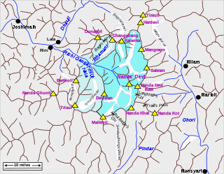
Rishiganga is a river in the Chamoli district, Uttarakhand, India. It springs from the Uttari Nanda Devi Glacier on the Nanda Devi mountain. It is also fed from the Dakshini Nanda Devi Glacier. Continuing through the Nanda Devi National Park, it flows into the Dhauliganga River near the village Rini.
 Parkachik Glacier, Nun Kun Massif


