
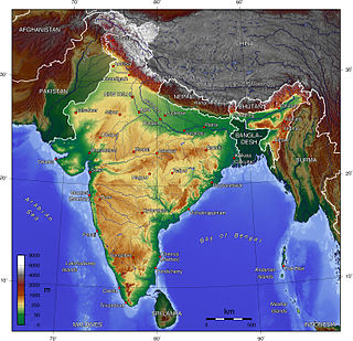
Ladakh is a region administered by India as a union territory and constitutes an eastern portion of the larger Kashmir region that has been the subject of a dispute between India and Pakistan since 1947 and India and China since 1959. Ladakh is bordered by the Tibet Autonomous Region to the east, the Indian state of Himachal Pradesh to the south, both the Indian-administered union territory of Jammu and Kashmir and the Pakistan-administered Gilgit-Baltistan to the west, and the southwest corner of Xinjiang across the Karakoram Pass in the far north. It extends from the Siachen Glacier in the Karakoram range to the north to the main Great Himalayas to the south. The eastern end, consisting of the uninhabited Aksai Chin plains, is claimed by the Indian Government as part of Ladakh, but has been under Chinese control.

Saser Kangri is a mountain in India. It is the highest peak in the Saser Muztagh, the easternmost subrange of the Karakoram range. Sasir Kangri is located within Ladakh.

Zanskar, Zahar (locally) or Zangskar, is a tehsil of Zanskar district, in the Indian union territory of Ladakh. The administrative centre is Padum. Zanskar, together with the neighboring region of Ladakh, was briefly a part of the kingdom of Guge in Western Tibet. Zanskar lies 250 km south of Kargil town on NH301.

Kargil district is a district in Indian-administered Ladakh in the disputed Kashmir-region, which is administered as a union territory of Ladakh. It is named after the city of Kargil, where the district headquarters lies. The district is bounded by the Indian-administered union territory of Jammu and Kashmir to the west, the Pakistani-administered administrative territory of Gilgit–Baltistan to the north, Ladakh's Leh district to the east, and the Indian state of Himachal Pradesh to the south. Encompassing three historical regions known as Purig, Dras and Zanskar, the district lies to the northeast of the Great Himalayas and encompasses the majority of the Zanskar Range. Its population inhabits the river valleys of the Dras, Suru, Wakha Rong, and Zanskar.
K12 is the second highest peak in the Saltoro Mountains, a subrange of the Karakoram range in the Siachen region and is administered as a part of Ladakh territory. Its name comes from its designation given during the original survey of the Karakoram range. In 1984, an Indian army expedition under Colonel Prem Chand took hold of this peak, from the side of Siachen glacier by traversing from the west.

Kargil or Kargyil is a city in Indian-administered Ladakh in the disputed Kashmir region. It is the joint capital of Ladakh, an Indian-administered union territory. It is also the headquarters of the Kargil district. It is the second-largest city in Ladakh after Leh. Kargil is located 204 kilometres (127 mi) east of Srinagar in Jammu and Kashmir, and 234 kilometres (145 mi) to the west of Leh. It is on the bank of the Suru River near its confluence with the Wakha Rong river, the latter providing the most accessible route to Leh.

Harish Kapadia is a Himalayan mountaineer, author and long-time editor of the Himalayan Journal from India.
The Rimo massif lies in the northern part of the remote Rimo Muztagh, a subrange of the Karakoram range. It is located about 20 km northeast of the snout of the Siachen Glacier and its main summit, Rimo I is the world's 71st highest mountain with an elevation of 7,385 metres (24,229 ft). The massif heads the large Central Rimo Glacier and South Rimo Glacier, as well as the smaller North Terong Glacier.

Ladakh is an administrative territory of India that has been under its control since 1947. The geographical region of Ladakh union territory is the highest altitude plateau region in India, incorporating parts of the Himalayan and Karakoram mountain ranges and the upper Indus River and valley.
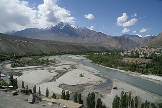
The Suru River is a tributary of the Indus River that flows largely through the Kargil district of Ladakh, India into Gilgit-Baltistan in Pakistan. The Suru Valley is coextensive with the Kargil tehsil, with the town of Kargil situated on its banks. The river enters the Kharmang District of Gilgit-Baltistan, coursing a brief length before joining the Indus near Marol.

The Dras River, also spelt Drass River, is a river in the Kargil district in the Indian union territory of Ladakh. It originates below the Zoji La pas in the Great Himalayan range and flows northeast towards Kargil, where it joins the Suru River. The Shingo River, which flows in a parallel direction in Pakistan-administered Baltistan, also joins the Dras River. The combined river is alternatively called Suru, Drass and Shingo by various local groups.
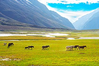
The Suru Valley is a valley in the Kargil District in the Union Territory of Ladakh, India. It is drained by the Suru River, a tributary of the Indus River. The valley's most significant town is Sankoo.

Pensi-la is a mountain pass in the Ladakh union territory of India, which is known as the Gateway to Zanskar. Pensi La is 4,400 metres (14,400 ft) above sea level and connects the Suru Valley region to the Zanskar Valley region. The summit at this end of the Suru Valley, the only peak which can be seen, is 7,012 metres (23,005 ft) high, while the mountain to the north is 6,873 metres (22,549 ft). The pass is about 25 km from Rangdum Monastery.
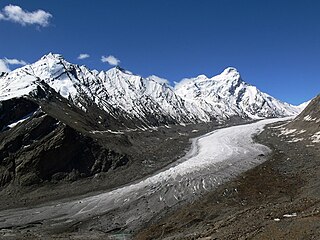
The Drang-Drung Glacier is a mountain glacier near the Pensi La pass on the Kargil-Zanskar Road in the Kargil district of Ladakh in India.
The Indian Himalayan Region is the section of the Himalayas within the Republic of India, spanning thirteen Indian states and union territories, namely Ladakh, Jammu and Kashmir, Himachal Pradesh, Uttarakhand, Sikkim, West Bengal, Manipur, Meghalaya, Mizoram, Nagaland, Tripura, Assam, and Arunachal Pradesh. The region is responsible for providing water to a large part of the Indian subcontinent and contains various flora and fauna.

The Doda River or the Stod River is a river 79 kilometres (49 mi) long, which forms the Stod Valley in the Zanskar valley of the Leh district in the Union Territory of Ladakh in India.

Mechoi Peak is a mountain with a peak elevation of 17,694 ft, in Drass region of Ladakh,India. Mechoi Peak is part of the Himalaya Range, and is located between Amarnath cave and Zojila. It lies 105 km north east from Srinagar, 25 km from Sonamarg in the east and 30 km from Drass. It rises from the glacier of its name Mechoi Glacier and is the source of Dras River in Drass, Ladakh. Mechoi Peak rises from the Mechoi glacier and is a pyramid-shaped peak with ice falls and ice fields at its bottom and ridges.
The Shafat Glacier — Parkachik Glacier is a 14 kilometres (9 mi) long glacier in the Himalayan Range in Ladakh, India.

The Pinnacle Peak is a part and third highest summit with elevation 22,740 ft of the Nun Kun mountain massif of the western Himalayan Range, located near the Suru valley, on Kargil Zanskar road 80 kilometers west of Kargil town.

The Kun Peak is a part of Nun Kun mountain massif in Ladakh, India. It is the second highest summit of the massif with elevation of 23,219 ft in the western Himalayan Range, located near the Suru valley, on the road connecting Kargil and Zanskar. It is located about 61 km south of Kargil and 141 km west of Leh.

