
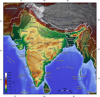
Ladakh is a region administered by India as a union territory and constitutes an eastern portion of the larger Kashmir region that has been the subject of a dispute between India and Pakistan since 1947 and India and China since 1959. Ladakh is bordered by the Tibet Autonomous Region to the east, the Indian state of Himachal Pradesh to the south, both the Indian-administered union territory of Jammu and Kashmir and the Pakistan-administered Gilgit-Baltistan to the west, and the southwest corner of Xinjiang across the Karakoram Pass in the far north. It extends from the Siachen Glacier in the Karakoram range to the north to the main Great Himalayas to the south. The eastern end, consisting of the uninhabited Aksai Chin plains, is claimed by the Indian Government as part of Ladakh, but has been under Chinese control.

Zanskar, Zahar (locally) or Zangskar, is the southwestern region of the Indian union territory of Ladakh. The administrative centre of Zanskar is Padum. Zanskar, together with the rest of Ladakh, was briefly a part of the kingdom of Western Tibet called Ngari Khorsum. Zanskar lies 250 km south of Kargil town on NH301.

Kargil district is a district in Indian-administered Ladakh in the disputed Kashmir-region, which is administered as a union territory of Ladakh. It is named after the city of Kargil, where the district headquarters lies. The district is bounded by the Indian-administered union territory of Jammu and Kashmir to the west, the Pakistani-administered administrative territory of Gilgit–Baltistan to the north, Ladakh's Leh district to the east, and the Indian state of Himachal Pradesh to the south. Encompassing three historical regions known as Purig, Dras and Zanskar, the district lies to the northeast of the Great Himalayas and encompasses the majority of the Zanskar Range. Its population inhabits the river valleys of the Dras, Suru, Wakha Rong, and Zanskar.

Padum is the main town and the administrative centre of the Zanskar tehsil in Kargil district, Ladakh, India. Named after the Buddhist guru Padmasambhava, it was historically one of the two main capitals of the Zanskar Kingdom, the other being Zangla. It is 235 km (146 mi) via the link road from Kargil city. The new Nimmu–Padum–Darcha road connects Padum directly to Leh in the east and to Darcha in Himachal Pradesh.

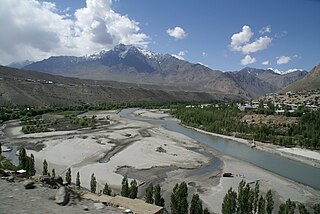
Kargil or Kargyil is a city in Indian-administered Ladakh in the disputed Kashmir region. It is the joint capital of Ladakh, an Indian-administered union territory. It is also the headquarters of the Kargil district. It is the second-largest city in Ladakh after Leh. Kargil is located 204 kilometres (127 mi) east of Srinagar in Jammu and Kashmir, and 234 kilometres (145 mi) to the west of Leh. It is on the bank of the Suru River near its confluence with the Wakha Rong river, the latter providing the most accessible route to Leh.

Ladakh is an administrative territory of India that has been under its control since 1947. The geographical region of Ladakh union territory is the highest altitude plateau region in India, incorporating parts of the Himalayan and Karakoram mountain ranges and the upper Indus River and valley.

Nun Kun is a mountain massif of the greater Himalayan range, located on the border of Jammu and Kashmir and Ladakh in northern India. It consists of two main peaks: Nun and Kun, separated from each other by a 4 km long snowy plateau, with a third peak of the massif, known as Pinnacle Peak, lying at its eastern end. Nun is the tallest peak of Jammu and Kashmir, while its sister peak Kun lies in Ladakh. It is about 250 km (160 mi) east of Srinagar. The Nun Kun massif is bounded to the north by the Suru valley and the Zanskar range, flanked to the east by the Pensi La (4400 m), which separates the Suru and Zanskar Valleys, while the Kishtwar National Park and the Krash Nai river lie to its south. The rocks predominantly are stratified sedimentary rocks composed of shale and sandstone. Metamorphic rocks and granite formations are also seen at places. The area is rich in minerals, especially garnets.
The Suru River is a tributary of the Indus River that flows largely through the Kargil district of Ladakh, India into Gilgit-Baltistan in Pakistan. The Suru Valley is coextensive with the Kargil tehsil, with the town of Kargil situated on its banks. The river enters the Kharmang District of Gilgit-Baltistan, coursing a brief length before joining the Indus near Marol.

The Dras River, also spelt Drass River, is a river in the Kargil district in the Indian union territory of Ladakh. It originates below the Zoji La pas in the Great Himalayan range and flows northeast towards Kargil, where it joins the Suru River. The Shingo River, which flows in a parallel direction in Pakistan-administered Baltistan, also joins the Dras River. The combined river is alternatively called Suru, Drass and Shingo by various local groups.
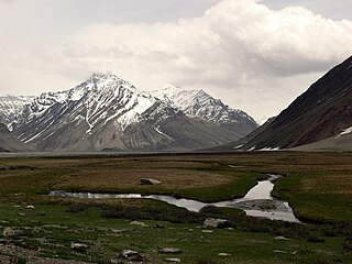
Rangdum is a village located in the Suru Valley in the union territory of Ladakh in Northern India. On one side are the colourful hills while on the other side are rocky mountains and glaciers, notably Drang-drung.

Pensi-la is a mountain pass in the Ladakh union territory of India, which is known as the Gateway to Zanskar. Pensi La is 4,400 metres (14,400 ft) above sea level and connects the Suru Valley region to the Zanskar Valley region. The summit at this end of the Suru Valley, the only peak which can be seen, is 7,012 metres (23,005 ft) high, while the mountain to the north is 6,873 metres (22,549 ft). The pass is about 25 km from Rangdum Monastery.

Zangla is a village in Zanskar tehsil of Kargil district, in the Indian union territory of Ladakh. It is located 262 km (163 mi) southeast of Kargil city, the district headquarters, and 32 km (20 mi) northeast of Padum, the headquarters of Zanskar. An ancient ruined palace, known as Zangla Fort or Zangla Khar is located on a hilltop 1 km (0.62 mi) outside the village, believed to be 11th-century. The Buddhist nunnery in Zangla contains some impressive paintings.

Tourism is one of the economic contributors to the union territory of Ladakh in Northern India. This union territory is located between the Karakoram mountain range to the north and the Himalayas to the south, and is situated at a height of 11,400 ft. Ladakh is composed of Leh and Kargil districts. The region contains prominent Buddhist sites and has an ecotourism industry.
The Indian Himalayan Region is the section of the Himalayas within the Republic of India, spanning thirteen Indian states and union territories, namely Ladakh, Jammu and Kashmir, Himachal Pradesh, Uttarakhand, Sikkim, West Bengal, Manipur, Meghalaya, Mizoram, Nagaland, Tripura, Assam, and Arunachal Pradesh. The region is responsible for providing water to a large part of the Indian subcontinent and contains various flora and fauna.

The Doda River or the Stod River is a river 79 kilometres (49 mi) long, which forms the Stod Valley in the Zanskar valley of the Leh district in the Union Territory of Ladakh in India.

Karsha Monastery or Karsha Gompa is a Buddhist monastery in the Padum Valley of the Zanskar region of the union territory of Ladakh in northern India. The Doda River flows past the monastery from its source at the Drang Drung Glacier of the Pensi La. It was founded by the translator Phagspa Shesrab. The monastery, also known by the name Karsha Chamspaling, was founded by Phagspa Shesrab, under the Gelugpa Order or Yellow Hats. It is 11 km north of Padum in Zanskar River valley.

Tsarap River, also known as Tsarap Chu, forms the eastern part of the Zanskar valley, in the Ladakh union territory of India. The 182 km (113 mi) long river is used for irrigation in riparian villages, and for adventure sports by tourists.

Zoji La is a high mountain pass in the Himalayas. It is in the Kargil district, Indian Union territory of Ladakh. Located in the Dras subdivision, the pass connects the Kashmir Valley to its west with the Dras and Suru valleys to its northeast and the Indus valley further east. National Highway #1 between Srinagar and Leh in the western section of the Himalayan mountain range, traverses the pass. As of late 2022, an all-weather Zoji-la Tunnel is under construction to mitigate seasonal road blockages due to heavy snowfall.
The Shafat Glacier — Parkachik Glacier is a 14 kilometres (9 mi) long glacier in the Himalayan Range in Ladakh, India.

Nimmu–Padum–Darcha road or Zanskar Highway is a road between the Indian union territory of Ladakh and the state of Himachal Pradesh, passing through the region of Zanskar. It connects Nimmu in the Indus Valley to Padum, the capital of Zanskar, and to Darcha village in Lahul and Spiti. It provides an alternative to the Leh–Manali Highway in linking Ladakh with the rest of India. It was built by the Border Roads Organisation (BRO) of the Indian Army. The construction of road was completed in March 2024. The already completed Atal tunnel, and the proposed unidirectional-twin-tube total-4-lane Shingo La Tunnel, which is expected to be completed by 2027 will provide all weather connectivity and reduce the distance from Manali to Kargil by 522 km.


