Saltoro Mountains

Last updated

Saltoro Mountains
Saltoro Muztagh
Un-kashmir-jammu.png
Highest point
PeakSaltoro Kangri
Elevation 7,742 m (25,400 ft)
Coordinates 35°24′01″N76°50′55″E / 35.40028°N 76.84861°E / 35.40028; 76.84861
Geography
Karakoram relief location map.svg
Red triangle with thick white border.svg
Saltoro Mountains
Location in Karakoram
Gilgit-Baltistan relief map.svg
Red triangle with thick white border.svg
Saltoro Mountains
Saltoro Mountains (Gilgit Baltistan)
Pakistan relief location map.jpg
Red triangle with thick white border.svg
Saltoro Mountains
Saltoro Mountains (Pakistan)
Ladakh relief map.svg
Red triangle with thick white border.svg
Saltoro Mountains
Saltoro Mountains (Ladakh)
India relief location map.jpg
Red triangle with thick white border.svg
Saltoro Mountains
Saltoro Mountains (India)
Location Actual Ground Position Line, on the border between Indian and Pakistani controlled territories
Borders onMasherbrum Mountains
Saltoro Mountains

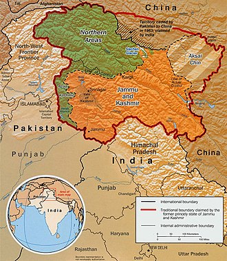
The Saltoro Mountains form a subrange within the Karakoram Range [1] and are situated in the southeastern part of the Karakoram. They lie on the southwest side of the Siachen Glacier, which is one of the two longest glaciers in the world outside the polar regions.[ citation needed ] The name "Saltoro" is also associated with the Saltoro Valley, located west of this range and descending on the Pakistani side of the Saltoro Range, which generally follows the Actual Ground Position Line (AGPL).

Contents

Saltoro Kangri peak, Saltoro River, and Saltoro Valley are features within the Saltoro Mountains range. The Actual Ground Position Line (AGPL) demarcates the boundary between the areas held by India and Pakistan in this region. In the Siachen area, India controls the high peaks and passes, while Pakistan occupies the lower peaks and valleys to the west. [2]

The Saltoro Mountains are part of the Lesser Karakorams and are situated on the southwestern side of the major Karakoram glaciers, including theSiachen, Baltoro, Biafo and Hispar Glacier, which run from east to west. The primary ridge of the Karakoram Range is located to the northeast of these glaciers.

The subranges of the main ridge are generally referred to as "Muztagh," while the mountain groups within the Lesser Karakorams are often designated as individual mountains, ranges or groups. [3]

The Saltoro Range is claimed by India as part of the Ladakh region and as part of the Gilgit–Baltistan region by Pakistan. Between 1984 and 1987, India assumed military control of the main peaks and passes of the range, with Pakistani forces holding the glacial valleys just to the west.[ citation needed ] Hence, despite high peaks and dramatic climbing opportunities, they are rarely visited except by military forces due to the ongoing Siachen Conflict.

On the southwest side, the Saltoro Mountains drop steeply to the valleys of the Kondus and Dansam Rivers, which join to form the Saltoro River, a tributary of the Shyok River. This in turn flows into the Indus River. To the northwest, the Kondus Glacier separates the range from the neighboring Masherbrum Mountains, while on the southeast, the Gyong River, Glacier, and Pass (Gyong La) separate the northern Saltoro Mountains from the southern Saltoro Mountains or "Kailas Mountains" (not to be confused with Tibet's sacred Mount Kailash).

Background

Indo-Pak mutually-agreed undisputed "International Border" (IB) in the black line, Indo-Pak "Line of Control" (LoC) in black dotted line in the north and west, Indo-Sino "Line of Actual" (LAC) in black dotted line in the east, Indo-Pak line across Siachen in north is "Actual Ground Position Line" (AGPL). The areas shown in green are the two Pakistani-controlled areas: Gilgit-Baltistan in the north and Azad Kashmir in the south. The area shown in orange is the Indian-controlled territories of Jammu and Kashmir, and Ladakh, and the diagonally-hatched area to the east is the Chinese-controlled area known as Aksai Chin. "Territories ceded by Pakistan to China claimed by India" in the north is Shaksgam (Trans-Karakoram Tract). Kashmir map.jpg
Indo-Pak mutually-agreed undisputed "International Border" (IB) in the black line, Indo-Pak "Line of Control" (LoC) in black dotted line in the north and west, Indo-Sino "Line of Actual" (LAC) in black dotted line in the east, Indo-Pak line across Siachen in north is "Actual Ground Position Line" (AGPL). The areas shown in green are the two Pakistani-controlled areas: Gilgit–Baltistan in the north and Azad Kashmir in the south. The area shown in orange is the Indian-controlled territories of Jammu and Kashmir, and Ladakh, and the diagonally-hatched area to the east is the Chinese-controlled area known as Aksai Chin. "Territories ceded by Pakistan to China claimed by India" in the north is Shaksgam (Trans-Karakoram Tract).
United Nations map of Siachen Glacier showing "Point NJ980420" (Point NJ9842) as starting point of "Actual Ground Position Line" (AGPL). Nubra River valley and Siachen glaciers held by India. AGPL starts from NJ9842 and goes north via Gyong La, Chumik, Sia La, Saltoro Glacier, Bilafond La to Indira Col West, all of which are held by India. Goma military camp, Masherbrum Range, Baltoro Glacier, Baltoro Glacier, Baltoro Muztagh and K2 are held by Pakistan. Un-kashmir-jammu.png
United Nations map of Siachen Glacier showing "Point NJ980420" (Point NJ9842) as starting point of "Actual Ground Position Line" (AGPL). Nubra River valley and Siachen glaciers held by India. AGPL starts from NJ9842 and goes north via Gyong La, Chumik, Sia La, Saltoro Glacier, Bilafond La to Indira Col West, all of which are held by India. Goma military camp, Masherbrum Range, Baltoro Glacier, Baltoro Glacier, Baltoro Muztagh and K2 are held by Pakistan.

Indo-Pakistan borders: SC, IB, LOC, AGPL

The actual India-Pakistan boundary is divided into 4 types of borders: disputed Sir Creek (SC) riverine border, mutually agreed India–Pakistan International Border (IB) from north of Sir Creek to north of Dhalan near Jammu, Line of Control (LoC) across disputed Kashmir and Ladakh regions from north of Dhalan in India and west of Chicken's Neck in Pakistan to Point NJ9842, and Actual Ground Position Line (AGPL) across Siachen from Point NJ9842 to Indira Col West. Siachen lies south of the Shaksgam ceded by Pakistan to China via the 1963 Sino-Pakistan Agreement but also claimed by India [4] and Aksai Chin held by China since 1962 but also claimed by India. The Shaksgam Tract controlled by China is located north of the Saltoro mountain range from the Apsarasas Kangri Range to 90 km northwest of K2. [5]

AGPL

The AGPL runs roughly along the Saltoro Mountains from Point NJ9842 on the India-Pakistan LoC to near La Yongma Ri, Gyong La, Gyong Kangri, Chumik Kangri, Bilafond La (pass) and nearby Bana Post, Saltoro Kangri, Ghent Kangri, and Sia La to the India–Pakistan–China trijunction northwest of Indira Col West on the Sino-Indian LAC. [6] [5] The peaks and passes under Pakistan's control such as Gayari Camp, Chogolisa, Baltoro Glacier, Conway Saddle, [5] Baltoro Muztagh, and Gasherbrum lie west of the AGPL.

Selected peaks

The following is a table of the peaks in the Saltoro Mountains which are over 7,200 metres (23,622 ft) in elevation and have over 500 metres (1,640 ft) of topographic prominence. (This is a common criterion for peaks of this stature to be independent.)

MountainHeight (m)Height (ft)CoordinatesProminence (m)Parent mountainFirst ascentAscents (attempts)
Saltoro Kangri 7,74225,400 35°23′57″N76°50′51″E / 35.39917°N 76.84750°E / 35.39917; 76.84750 2,160 Gasherbrum I 19622 (1)
K12 7,42824,370 35°17′42″N77°01′18″E / 35.29500°N 77.02167°E / 35.29500; 77.02167 1,978Saltoro Kangri19744 (2)
Ghent Kangri (Mount Ghent)7,40124,281 35°31′03″N76°48′01″E / 35.51750°N 76.80028°E / 35.51750; 76.80028 1,493 Saltoro Kangri 19614 (0)
Sherpi Kangri 7,38024,213 35°27′58″N76°46′53″E / 35.46611°N 76.78139°E / 35.46611; 76.78139 900 Ghent Kangri 19761 (1)

See also

Borders
Conflicts
Operations
Other related topics

Related Research Articles

<span class="mw-page-title-main">Siachen Glacier</span> Glacier located in the eastern Karakoram range in the Himalayas

The Siachen Glacier is a glacier located in the eastern Karakoram range in the Himalayas at about 35.421226°N 77.109540°E, just northeast of the point NJ9842 where the Line of Control between India and Pakistan ends. At 76 km (47 mi) long, it is the longest glacier in the Karakoram and second-longest in the world's non-polar areas. It falls from an altitude of 5,753 m (18,875 ft) above sea level at its head at Indira Col on the India–China border down to 3,620 m (11,875 ft) at its terminus. The entire Siachen Glacier, with all major passes, has been under the administration of India as part of the union territory of Ladakh, located in the Kashmir region since 1984. Pakistan maintains a territorial claim over the Siachen Glacier and controls the region west of Saltoro Ridge, lying west of the glacier, with Pakistani posts located 3,000 ft below more than 100 Indian posts on the ridge.

K12 is the second highest peak in the Saltoro Mountains, a subrange of the Karakoram range in the Siachen region of Ladakh. Its name comes from its designation given during the original survey of the Karakoram range. In 1984, an Indian army expedition under Colonel Prem Chand took hold of this peak, from the side of Siachen glacier by traversing from the west.

<span class="mw-page-title-main">Trans-Karakoram Tract</span> Chinese-administered area in the northern half of Kashmir near the Shaksgam River

The Trans-Karakoram Tract, also known as the Shaksgam Tract, is an area of approximately 5,200 km2 (2,000 sq mi) north of the Karakoram watershed, including the Shaksgam valley. The tract is administered by China as part of its Taxkorgan and Yecheng counties in the Xinjiang Uyghur Autonomous Region. Although the Shaksgam tract was never under the control of Pakistan since 1947, in the 1963 Sino-Pakistan Agreement, Pakistan recognized Chinese sovereignty over the Shaksgam tract, while China recognized Pakistani sovereignty over the Gilgit Agency, and a border based on actual ground positions was recognized as the international border by China and Pakistan. It, and the entire Kashmir region, is claimed by India.

<span class="mw-page-title-main">Operation Safed Sagar</span> 1999 Indian military operation

Operation Safed Sagar was the code name assigned to the Indian Air Force's role in acting jointly with the Indian Army during the 1999 Kargil war that was aimed at flushing out regular and irregular troops of the Pakistani Army from vacated Indian Positions in the Kargil sector along the Line of Control. It was the first large scale use of Airpower in the Jammu and Kashmir region since the Indo-Pakistani War of 1971.

<span class="mw-page-title-main">Saltoro Kangri</span> Mountain in disputed Kashmir region administered by India

Saltoro Kangri, formerly known as Peak 36, is the highest peak of the Saltoro Mountains subrange of Karakoram range, also known as the Saltoro Range, which is a part of the Karakoram. Saltoro Kangri is a name generally used for the twin peaks, Saltoro Kangri I and Saltoro Kangri II, connected by a saddle. While comparing the heights the generic term Saltoro Kangri is applied to the higher peak, Saltoro Kangri I, which is the 31st highest mountain in the world in remote reaches of Karokaram. It is located on the Actual Ground Position Line between Indian controlled territory in the Siachen region and Pakistani controlled territory west of the Saltoro Range.

<span class="mw-page-title-main">Operation Meghdoot</span> 1984 Indian military operation to capture the Siachen Glacier in Kashmir

Operation Meghdoot was the codename for the Indian Armed Forces' operation to seize control of the Siachen Glacier in the then state of Jammu and Kashmir, precipitating the Siachen conflict. Executed in the morning of 13 April 1984 in the highest battlefield in the world, Meghdoot was the first military offensive of its kind. The operation preempted Pakistan's impending Operation Ababeel and was a success, resulting in Indian forces gaining control of the Siachen Glacier in its entirety.

<span class="mw-page-title-main">Ghent Kangri</span> Mountain in Pakistan/India

Ghent Kangri is a high peak near the north end of the Saltoro Mountains, a subrange of the Karakoram range. It is located west of the Siachen Glacier near the Actual Ground Position Line between India and Pakistan.

<span class="mw-page-title-main">Sherpi Kangri</span> Mountain peak in the Karakoram range

Sherpi Kangri is a mountain peak in the Karakoram Range. It lies six km south of Ghent Kangri and ten km northwest of Saltoro Kangri.

<span class="mw-page-title-main">Bilafond La</span> Mountain pass, Pakistan

Bilafond La (meaning "Pass of the Butterflies" in Balti language, also known as the Saltoro Pass, is a mountain pass situated on Saltoro Ridge, sitting immediately west of the vast Siachen Glacier, some 40 km directly north of map point NJ 980420 which defined the end of the 1972 Line of Control between Pakistan and India as part of the Simla Agreement. Bilafond La is on the ancient Silk Route linking the Indian Subcontinent and China.

<span class="mw-page-title-main">Sia La</span>

Sia La is a mountain pass situated on Saltoro Ridge, in Ladakh, India, some 60 km (37 mi) north-northwest of map point NJ9842 which defined the end of the 1972 Line of Control between India and Pakistan as part of the Simla Agreement. Sia La sits near the Chinese border and immediately northwest of the upper part of the vast Siachen Glacier, connecting that glacier to the Pakistani-controlled Kondus Glacier and valley to the west.

<span class="mw-page-title-main">Gyong La</span>

Gyong La is a mountain pass situated on Saltoro Ridge southwest of the vast Siachen Glacier, some 20 km (12 mi) directly north of map point NJ9842 which defined the end of the 1972 Line of Control between India and Pakistan. With Pakistan controlling areas just to the west along Chumik Glacier, the immediate Gyong La area has been under India's control since 1989. Dozens of Indian military tents and other equipment are visible in 2013 and 2016 Google Earth imagery 100 meters east, 670 meters northeast, and 2.7 km east-northeast of Gyong La, linked by clear trails. Nearer the former Pakistani "Naveed Top" position and 3.85 km west-northwest of Gyong La is a post and helipad is visible in 2001 and 2016 Google Earth imagery at 5,800 m (19,000 ft) elevation, higher than both the Indian positions and Gyong La.

<span class="mw-page-title-main">Siachen Base Camp (India)</span>

Siachen Base Camp, 12,000 feet above sea level at Partapur, is a base camp of 102 Infantry Brigade of XIV Corps of Indian Army which protects 110 km long Actual Ground Position Line (AGPL) with at least 108 forward military outposts and artillery observation posts in the disputed region of Siachen Glacier in Ladakh Union Territory of India. It is approximately 6 hours drive north from the town of Leh via one of the highest vehicle-accessible passes in the world, Khardung La at 17,582 feet. Bana Top (20,500 ft) is the highest post in the region, which requires 80 km and 20 day trek for troops. Pahalwan Post and posts near Indira Col are other high posts. Kumar Post or Kumar Base, named after the Colonel Narendra "Bull" Kumar, serves as the battalion head quarter located 60 km from the Siachen base towards Indira Col. The Siachen Brigade consists of five to eight battalions of Ladakh Scouts supported by artillery, air defence, engineer and other logistic units. Pakistan has not been able to scale the crest of the Saltoro Range occupied by India. The temperature goes down to minus 86 °C during winters with icy 300 kmph blizzards. The average temperature is between minus 25 °C during day and minus 55 °C during the night.

<span class="mw-page-title-main">Actual Ground Position Line</span> Division line between Indian and Pakistani military posts on the Siachen Glacier in Kashmir

The Actual Ground Position Line (AGPL) divides current positions of Indian and Pakistani military posts and troops along the entire 110 kilometres (68 mi) long frontline in the disputed region of Siachen Glacier. AGPL generally runs along the Saltoro Mountains range, beginning from the northernmost point of the (LOC) at Point NJ 9842 and ending in the north on the Indira Ridge at the India-China-Pakistan LAC tripoint near Sia Kangri about 4 km (2.5 mi) northwest of Indira Col West, with peaks in excess of 7,000 m (23,000 ft) and temperatures ranging to around −55 °C (−67 °F). India gained control of 1,000 square miles (2,600 km2) of disputed territory in 1984 because of its military operations in Siachen. A cease-fire was announced in 2003.

NJ9842, also called NJ 980420, is the northernmost demarcated point of the India-Pakistan cease fire line in Kashmir known as the Line of Control (LoC). The India–Pakistan AGPL, begins from the NJ9842 on LoC and ends near the Indira Ridge at the trijunction of areas controlled by China, India, and Pakistan.

Indira Col West is a mountain pass at 5,988 metres (19,646 ft)) altitude on the Indira Ridge of Siachen Muztagh in Karakoram Range. It is on the border between Indian-controlled Siachen Glacier and the Chinese-controlled Trans-Karakoram Tract, close to the tripoint of India, Pakistan, and China. The India-Pakistan Actual Ground Position Line (AGPL) in the Siachen area ends near the pass. It is possible to ascend the pass from both the north and south sides controlled by China and India respectively.

<span class="mw-page-title-main">Chumik Glacier</span> Glacier in Pakistan

Chumik Glacier is located in the Siachen region. Located on the west of Saltoro ridge, it is a 4-mile-long offshoot of the Bilafond Glacier.

Operation Rajiv was the codename for an Indian Army operation that aimed to capture a high point along the Actual Ground Position Line (AGPL) on the Siachen Glacier in June 1987. Prior to this operation, the area had been under the control of Pakistani forces, who had established a post on the peak, designated Quaid Post. Following India's successful capture of the peak, the post was renamed to Bana Top after Naib Subedar Bana Singh, who led the operation. Since Operation Rajiv in 1987, India continues to hold this post, which lies just to the south of the strategic Bilafond La mountain pass, also controlled by India. Alongside the higher-altitude installations, India has also established posts on the slopes at lower heights in this sector.

<span class="mw-page-title-main">China–Pakistan border</span> International border

The China–Pakistan border is 596 kilometres (370 mi) and runs west–east from the tripoint with Afghanistan to the disputed tripoint with India in the vicinity of the Siachen Glacier. It traverses the Karakoram Mountains, one of the world's tallest mountain ranges. Hunza District, Shigar District and Ghanche District in Gilgit-Baltistan Administrative Territory of Pakistan, border Taxkorgan Tajik Autonomous County and Kargilik/Yecheng County in Kashgar Prefecture, Xinjiang Uygur Autonomous Region, China.

<span class="mw-page-title-main">Saltoro Valley</span>

Saltoro valley is Pakistan's highest valley. It is part of Baltistan, and is held by Pakistan. Along with Saltoro Kangri peak and the Saltoro River, it is near the Saltoro Mountain Range. It lies near world's highest battleground Siachen, a territory disputed by India and Pakistan. The Actual Ground Position Line (AGPL) between India held and Pakistan held area runs through this range where higher peaks and passes of disputed Siachen area are held by India and Pakistan occupies the lower peaks and valleys. In 1984, India captured most of the disputed Siachen area in the Operation Meghdoot. In April 1986, Pakistan launched an assault in the area, gaining control of a high point in the area located south of Bilafond La, and established a military post on the peak which was named "Quaid Post" in honour of their leader Quaid-e-Azam Muhammad Ali Jinnah. Between 23 and 26 June 1987, India launched a counter Operation Rajiv and snatched the Quaid Post from Pakistan, renaming it Bana Top in the honor of Bana Singh who was awarded India's highest gallantry award Param Vir Chakra.

<span class="mw-page-title-main">Dhalan</span> Village in Jammu and Kashmir, India

Dhalan is a village located on a river bank in Jammu district of Jammu and Kashmir union territory of India. Dhalan is located on the India-Pakistan LoC, which begins just north of Dahlan. The important geostrategic Chicken's Neck military sector of Pakistan lies southeast of Dhalan.

References

  1. "Tryst With Deceit?". outlookindia.com/.
  2. How India realised it was at risk of losing the Siachen glacier to Pakistan, The Print, 12 April 2018.
  3. Mason, Kenneth (1938). "Karakoram Nomenclature". Himalayan Journal 10. Retrieved 10 February 2014.
  4. "Pakistan: Signing with the Red Chinese". Time (magazine). 15 March 1963. Retrieved 11 January 2020.
  5. 1 2 3 R Baghela and M Nüsserab, 2015, Securing the heights: The vertical dimension of the Siachen conflict between India and Pakistan in the Eastern Karakoram, Political Geography (journal), Volume 48, Pages 24–36.
  6. "Manning the Siachen Glacier". Bharat Rakshak Monitor. 2003. Archived from the original on 14 June 2012. Retrieved 27 January 2011.

Sources