
The Line of Control (LoC) is a military control line between the Indian and Pakistani controlled parts of the former princely state of Jammu and Kashmir—a line which does not constitute a legally recognized international boundary, but serves as the de facto border. Originally known as the Cease-fire Line, it was redesignated as the Line of Control following the Simla Agreement, which was signed on 3 July 1972. The part of the former princely state that is under Indian control is divided into the union territories of Jammu and Kashmir and Ladakh, while the Pakistani-controlled part is divided into Azad Jammu and Kashmir and Gilgit–Baltistan. The northernmost point of the Line of Control is known as NJ9842. The India–Pakistan border continues from the southernmost point on the LoC.
The Karachi Agreement of 1949 was signed by the military representatives of India and Pakistan, supervised by the United Nations Commission for India and Pakistan, establishing a cease-fire line in Kashmir following the Indo-Pakistani War of 1947. It established a cease-fire line which has been monitored by United Nations observers from the United Nations since then.

The Trans-Karakoram Tract, also known as Shaksgam or the Shaksgam Tract, is an area of more than 5,180 km2 (2,000 sq mi) north of the Karakoram, including the Shaksgam valley and Raskam. The tract is administered by the People's Republic of China as part of its Taxkorgan and Yecheng counties in the Xinjiang Uyghur Autonomous Region. Although the area was not part of Kashmir or under Pakistan's control since 1947, it was claimed by Pakistan as part of Kashmir until the 1963 Sino-Pakistan Agreement. It is claimed by India as part of the union territory of Ladakh.

Saltoro Kangri is the highest peak of the Saltoro Mountains subrange of Karakoram range, also known as the Saltoro Range, which is a part of the Karakoram. Saltoro Kangri is a name generally used for the twin peaks, the Saltoro Kangri I to the south and the Saltoro Kangri II, connected by a saddle. While comparing the heights the generic term Saltoro Kangri is applied to the higher peak, Saltoro Kangri I, which is the 31st highest mountain in the world in remote reaches of Karokaram. It is located on the Actual Ground Position Line between Indian controlled territory in the Siachen region and Pakistani controlled territory west of the Saltoro Range.

Operation Meghdoot was the codename for the Indian Armed Forces' operation to seize control of the Siachen Glacier in Kashmir, precipitating the Siachen conflict. Executed in the morning of 13 April 1984, this military operation, launched in the highest battlefield in the world, was the first offensive of its kind. The operation preempted Pakistan's impending Operation Ababeel and was a success, resulting in Indian forces gaining control of the Siachen Glacier in its entirety.

The Saltoro Mountains are a subrange of the Karakoram Range. They are located in the southeast Karakoram on the southwest side of the Siachen Glacier, one of the two longest glaciers outside the polar regions. The name given to this range is shared with the Saltoro Valley which is located to the west of this range, downslope on the Pakistan side of the Saltoro Range which generally follows the Actual Ground Position Line. Saltoro Kangri peak, Saltoro River, and Saltoro Valley are features on this range. Actual Ground Position Line (AGPL) between India held and Pakistan held area runs through this range where higher peaks and passes of disputed Siachen area are held by India and Pakistan occupies the lower peaks and valleys.

Ghent Kangri is a high peak near the north end of the Saltoro Mountains, a subrange of the Karakoram range. It is located west of the Siachen Glacier near the Actual Ground Position Line between India and Pakistan.

Bilafond La (meaning "Pass of the Butterflies" in Balti language, also known as the Saltoro Pass, is a mountain pass situated on Saltoro Ridge, sitting immediately west of the vast Siachen Glacier, some 40 km directly north of map point NJ 980420 which defined the end of the 1972 Line of Control between Pakistan and India as part of the Simla Agreement. Bilafond La is on the ancient Silk Route linking the Indian Subcontinent and China.
Sia La is a mountain pass situated on Saltoro Ridge, some 60 km (37 mi) north-northwest of map point NJ9842 which defined the end of the 1972 Line of Control between India and Pakistan as part of the Simla Agreement. Sia La sits near the China border and immediately northwest of the upper part of the vast Siachen Glacier, connecting that glacier to the Pakistani-controlled Kondus Glacier and valley to the west.

Thoise or Thoise Airbase is a military airfield and small village in Nubra Valley, Ladakh, India, occupying the only large piece of flat land in the area. The airstrip is a critical facility enabling a quick inflow of men and material from the Indian interior to Siachen, a glacier, helipad and battleground near the Actual Ground Position Line between India and Pakistan.

The Chicken's Neck, or the Akhnoor Dagger, is the name for a narrow strip of Pakistani territory that extends into the Indian Union Territory of Jammu and Kashmir south of Akhnoor. This sensitive piece of land, which lies on the de facto Indo–Pakistani border on the west side of the disputed region of Kashmir, is part of Punjab Province's Sialkot District and measures roughly 170 km2 (66 sq mi). It has been a focal point in all the wars between India and Pakistan, as it is seen as a corridor towards most of Jammu and Kashmir. One of the main thrusts of Operation Grand Slam in the Indo-Pakistani War of 1965 was to capture Akhnoor through the Chicken's Neck, which could potentially have choked the Indian Army in the region; however, the plan failed.
Gyong La is a mountain pass situated on Saltoro Ridge southwest of the vast Siachen Glacier, some 20 km (12 mi) directly north of map point NJ9842 which defined the end of the 1972 Line of Control between India and Pakistan. With Pakistan controlling areas just to the west along Chumik Glacier, the immediate Gyong La area has been under India's control since 1989. Dozens of Indian military tents and other equipment are visible in October 2013 Google Earth imagery both 670 meters northeast and 2.7 km east-northeast of Gyong La, linked by clear trails. Now under Indian Army's control the former Pakistani "Naveed Top" post 3.85 km west-northwest of Gyong La is visible in September 2001 Google Earth imagery at 5,800 m (19,000 ft) elevation, higher than both the Indian positions and Gyong La.
Siachen Base Camp, 12,000 feet above sea level at Partapur, is a base camp of 102 Infantry Brigade of XIV Corps of Indian Army which protects 110 km long Actual Ground Position Line (AGPL) with at least 108 forward military outposts and artillery observation posts in the disputed region of Siachen Glacier in Ladakh Union Territory of India. It is approximately 6 hours drive north from the town of Leh via the world's highest motorable pass Khardung La at 18,380 feet. Bana Top is the farthest and highest post which is 80 km away and takes up to 20 days trek for troops to reach, Pahalwan Post and Indira Col are other highest posts. Kumar Post or Kumar Base, which serves as the battalion head quarter, is named after the Colonel Narendra "Bull" Kumar and it is 60 km from the Siachen base towards Indira Col. The Siachen brigade consists of five to eight battalions of Ladakh Scouts supported by artillery, air defence, engineer and other logistic units. Pakistan has not been able to scale the crest of the Saltoro Range occupied by India. The temperature goes down to minus 86°C during winters with icy 300 kmph blizzards. The average temperature is between minus 25°C during day and minus 55°C during the night.

The Actual Ground Position Line (AGPL) divides current positions of Indian and Pakistani military posts and troops across the entire 110 kilometres (68 mi) long front line in the disputed region of Siachen Glacier. AGPL generally runs along the Saltoro Mountains range, beginning from the northernmost point of the (LOC) at Point NJ 9842 and ending in the north on the Indira Ridge at the India-China-Pakistan LAC tripoint a km southeast of Sia Kangri and 3 km southwest of Indira Col West, with peaks in excess of 7,000 meters and average temperature around minus 50 celsius. India gained control of 1,000 square miles (2,600 km2) of disputed territory in 1984 because of its military operations in Siachen. A cease-fire was announced in 2003.
NJ9842, also called NJ 980420, is the northernmost demarcated point of the India-Pakistan cease fire line in Kashmir known as the Line of Control (LoC). The India–Pakistan AGPL, begins from the NJ9842 on LoC and ends on the Indira Ridge at the India-China-Pakistan LAC.
Indira Col West is a col or mountain pass at 5,988 metres (19,646 ft)) altitude on the Indira Ridge of Siachen Muztagh in Karakoram Range. It is on the border between Indian-controlled Siachen Glacier and the Chinese-controlled Trans-Karakoram Tract, close to the tripoint of India, Pakistan, and China. The India-Pakistan Actual Ground Position Line (AGPL) in the Siachen area ends at the pass. It is possible to ascend the pass from both the north and south sides controlled by China and India respectively.
Chumik Glacier is located in the Siachen region. Located on the west of Saltoro ridge, it is a 4-mile-long offshoot of the Bilafond Glacier.
Operation Ababeel was the codename for the military operation planned by the Pakistan Armed Forces with the intention to capture and assume absolute control over the Siachen Glacier in the disputed Kashmir region. The operation was effectively thwarted on 13 April 1984 by India's preemptive Operation Meghdoot, which resulted in Indian troops successfully gaining control of the entire glacier before Pakistan, sparking the Siachen conflict.
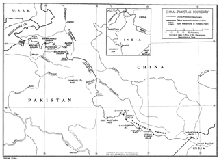
The China–Pakistan border is 592 kilometres (368 mi) and runs west-east from the tripoint with Afghanistan to the disputed tripoint with India in the vicinity of the Siachen Glacier. It traverses the Karakorum Mountains, one of the world's tallest mountain ranges. Hunza District, Shigar District and Ghanche District in Gilgit-Baltistan administered by Pakistan border Taxkorgan Tajik Autonomous County and Kargilik/Yecheng County in Kashgar Prefecture, Xinjiang Uygur Autonomous Region, China.
Saltoro valley is Pakistan's highest valley. It is part of Baltistan, held by Pakistan and also claimed by India. Along with Saltoro Kangri peak and Saltoro River, it is part of Saltoro Mountain Range. It lies in world's highest battleground Siachen, a territory disputed by India and Pakistan. Actual Ground Position Line (AGPL) between India held and Pakistan held area runs through this range where higher peaks and passes of disputed Siachen area are held by India and Pakistan occupies the lower peaks and valleys. In 1984, India captured most of the disputed Siachen area in the Operation Meghdoot. In April 1986, Pakistan launched an assault in the area, gaining control of the highest peak in the area located south of Bilafond La, and established a military post on the peak which was named as the peak "Quaid Post" in honour of their leader Quaid-e-Azam Muhammad Ali Jinnah. Between 23–26 June 1987, India launched a counter Operation Rajiv and snatched the Quaid Post from Pakistan which is the highest peak in this area overlooking the Saltoro Valley, renamed it Bana Top in the honor of Bana Singh who was awarded India's highest gallantry award Param Vir Chakra.


