
Anantnag is a district in the Indian union territory of Jammu and Kashmir. It is one of ten districts which make up the Kashmir Valley. The district headquarters is Anantnag city. As of 2011, it was the third most populous district of Jammu and Kashmir, after Jammu and Srinagar.

The Pir Panjal Range is a group of mountains in the Lesser Himalayan region, running from east-southeast (ESE) to west-northwest (WNW) across the Indian state of Himachal Pradesh, the Indian administrated Union Territory of Jammu and Kashmir and the Pakistani administered territory of Azad Kashmir, where the average elevation varies from 1,400 m (4,600 ft) to 4,100 m (13,500 ft). The Himalayas show a gradual elevation towards the Dhauladhar and Pir Panjal ranges. Pir Panjal is the largest range of the Lesser Himalayas. Near the bank of the Sutlej River, it dissociates itself from the Himalayas and forms a divide between the Beas and Ravi rivers on one side and the Chenab on the other. The renowned Galyat mountains are also located in this range. The region is connected to the Valley of Kashmir via Mughal Road and used to be the historical connection of Kashmir with India.
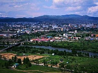
Anantnag, also called Islamabad, is the administrative headquarters of the Anantnag district in the Indian union territory of Jammu and Kashmir. It is located at a distance of 53 kilometres from the union territory's capital Srinagar. It is the third largest city in Jammu and Kashmir after Srinagar and Jammu with an urban agglomerate population of 159,838 and municipal limit population of 109,433.

Verinag (; or Vitastatra is a tourist place and a notified area committee with tehsil status in Anantnag district in the union territory of Jammu and Kashmir, India. It is about 26 kilometers away from Anantnag and approximately 78 kilometres south-east from Srinagar which is the summer capital of the union territory of Jammu and Kashmir. Verinag is also the first tourist spot of Kashmir Valley when travelling by road from Jammu, the winter capital of the union territory of Jammu and Kashmir towards Srinagar, the summer capital of the union territory of Jammu and Kashmir. It lies at the entry point of Kashmir Valley right after crossing Jawahar Tunnel and is also known as Gateway of Kashmir.

Qazigund, also known as Quazigund, is a town and a notified area committee in Anantnag district in the union territory of Jammu and Kashmir, India. Qazigund is located at 33.59°N 75.16°E. It has an average elevation of 1670 m (5478 feet) above mean sea level.

Sonamarg or Sonmarg, known as Sonamarag in Kashmiri, is a hill station located in the Ganderbal District of Jammu and Kashmir, India. It is located about 80 kilometres (50 mi) northeast of the capital city, Srinagar.

Jammu and Kashmir is home to several valleys such as the Kashmir Valley, Chenab Valley, Sindh Valley and Lidder Valley. Some major tourist attractions in Jammu and Kashmir are Srinagar, the Mughal Gardens, Gulmarg, Pahalgam, Patnitop and Jammu. Every year, thousands of Hindu pilgrims visit holy shrines of Vaishno Devi and Amarnath which has had significant impact on the state's economy.

Ramban is one of the 20 districts in the union territory of Jammu and Kashmir, India. Ramban is located in the lap of the Pir Panjal mountain range. It was carved out of the erstwhile Doda District on 1 April 2007. Ramban town is the district headquarters. The town is located midway between Jammu and Srinagar along the Chenab river in Chenab Valley on National Highway-44, approximately 151 km from Jammu and Srinagar.

Kulgam District is a district in the Indian union territory of Jammu and Kashmir. It is located at a distance of 18 km towards south-west of Anantnag. The district comprises of block, tehsil and town of Kulgam.

Kishtwar District is a district of the Indian union territory of Jammu and Kashmir of India. As of 2011, it is the largest and least populous district of Jammu and Kashmir. It is situated on the banks of the Chenab/Chandrabhaga River.
Daksum located in the green forests of Jammu and Kashmir, India at Anantnag-Semthan-Kishtwar road (NH-1B), is a natural scenic spot.
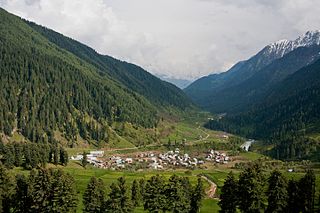
Aru is a tourist spot in the Anantnag District of Jammu and Kashmir, India. It is located around 12 km from Pahalgam, 11 km upstream from the Lidder River. Noted for its scenic meadows, lakes and mountains, it is a base camp for trekking to the Kolhoi Glacier and Tarsar Lake. The village lies on the left bank of the Aru river, which is a tributary of the Lidder river.

The Lolab Valley is a Himalayan valley located in union territory of Jammu and Kashmir, India. The entrance to the valley lies 9 km (5.6 mi) north of Kupwara city, and the centre of the valley lies 114 km (71 mi) northwest of Srinagar, the capital of Jammu and Kashmir. It is an oval-shaped valley 15 miles (24 km) long with an average width of 2 miles (3.2 km).
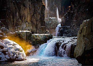
Aharbal is a hill station in the south-western part of Kashmir Valley in the Indian union territory of Jammu and Kashmir, south of the summer capital of Srinagar. The place is quite peaceful and suitable for expeditions, trekking, vlogging, photography, and fishing. Due to mesmerising look of meadows, pine and fir tree forests, the abutting snow clad mountains, the waterfall attracts many Indian and international tourists. Aharbal Waterfall is also known as Niagara Waterfall of Kashmir.

The Chenab Valley, also known as the Chenab Region, is the river valley of the Chenab River flowing through the Kishtwar, Doda, and Ramban districts of Jammu Division in Jammu and Kashmir, India.
The Bringhi or Brengi river is a river in Jammu and Kashmir, India. It is formed by the confluence of three streets Nowbugh streem, Ahlan Gadol Streem, and Daksum Streem. Nowbugh Streem originates from the glaciers of Margan Top, Daksum streem originates from the glaciers of Sinthan in Anantnag district. The river passes through a gorge at Daksum. Kokernag is in the Bringhi river valley.
The Jammu–Srinagar National Highway is the northernmost segment of NH 44. It runs from Srinagar in the Kashmir Valley southward to the city of Jammu.
Breng Valley is located in Anantnag district in the Indian territory of Jammu and Kashmir. The valley is named after the rivulet Brengi which is a tributary of famous Jhelum River. The valley spans over 40 km on either side of Brengi and Kokernag is the center of the valley where famous Kokernag Garden is located. The valley has been praised by the Kashmiri Sufi saint Sheikh Noor-u-din Wali as Breng Gov Sonsun Preng, i.e. Breng Valley is a Golden Crown.
The name Chandimarh is derived from two words "Chand" (some) and "Marh"(a hut made up of stone and clay). During 17th century the mughal emperor Jahangir used to visit Kashmir through this way and had constructed some huts in Chandimarh where he and his cavalry was staying for some days. It's is said that during his stay, Noor Jahan wife of Jahangir and her friends used to take bath in water fall which is later called as Noori Chamb located at the border of village Chandimarh and Behramgalla. Place to visit,Chandimarh Park, Noori Chamb Lehar play ground which is the top most point of village. Chandimarh is also famous for its Kulcha which is made up of whole grain and have very crispy and crunchy in taste. Chandimarh is the favourite tourist destination for people of poonch, rajouri and Jammu who mostly visit during summer season and enjoy the beauty and lush green scenery of the area. Most people do farming and main staple crop is Maize which is grown largely and other cultivable crops are pulses,Peas, potatoes, Garlic. The walnuts and Rajma are exported to poonch, rajouri and Jammu as well and have a greater demand. Chandimarh is might be the only village that have no road connectivity till now. And there are about ten thousand people residing in Chandimarh village and also have two Panchayat consist of 16 wards, each Panchayat have 8 wards. The mughal road is the only source of connectivity which pass through the two wards and rest Of area have been neglected.

Margan Top or Margan Pass is a mountain pass, connecting Warwan Valley in Kishtwar District with the main Kashmir Valley. It is located south of Anantnag district in the Indian state of Jammu and Kashmir.

