Sia La

Last updated • 1 min readFrom Wikipedia, The Free Encyclopedia

Sia La
Pakistan Gilgit-Baltistan relief map.svg
Red pog.svg
Location in Gilgit Baltistan
Pakistan relief location map.jpg
Red pog.svg
Sia La (Pakistan)
Elevation 5,589 m (18,337 ft)
Location Karakoram range, Gilgit-Baltistan, Pakistan
Range Eastern Karakoram Range
Coordinates 35°34′55″N76°47′33″E / 35.58194°N 76.79250°E / 35.58194; 76.79250
Sia La
Indo-Pak mutually-agreed undisputed "International Border" (IB) in the black line, Indo-Pak "Line of Control" (LoC) in black dotted line in the north and west, Indo-Sino "Line of Actual" (LAC) in black dotted line in the east, Indo-Pak line across Siachen in north is "Actual Ground Position Line" (AGPL). The areas shown in green are the two Pakistani-controlled areas: Gilgit-Baltistan in the north and Azad Kashmir in the south. The area shown in orange is the Indian-controlled territories of Jammu and Kashmir, and Ladakh, and the diagonally-hatched area to the east is the Chinese-controlled area known as Aksai Chin. "Territories ceded by Pakistan to China claimed by India" in the north is Shaksgam (Trans-Karakoram Tract). Kashmir map.jpg
Indo-Pak mutually-agreed undisputed "International Border" (IB) in the black line, Indo-Pak "Line of Control" (LoC) in black dotted line in the north and west, Indo-Sino "Line of Actual" (LAC) in black dotted line in the east, Indo-Pak line across Siachen in north is "Actual Ground Position Line" (AGPL). The areas shown in green are the two Pakistani-controlled areas: Gilgit–Baltistan in the north and Azad Kashmir in the south. The area shown in orange is the Indian-controlled territories of Jammu and Kashmir, and Ladakh, and the diagonally-hatched area to the east is the Chinese-controlled area known as Aksai Chin. "Territories ceded by Pakistan to China claimed by India" in the north is Shaksgam (Trans-Karakoram Tract).
United Nations map of Siachen Glacier showing "Point NJ980420" (Point NJ9842) as the starting point of the "Actual Ground Position Line" (AGPL), Goma military camp of Pakistan, Nubra River valley and Siachen glaciers held by India, and Bilafond La and Sia La (north of NJ9842) also held by India. Masherbrum Range, Baltoro Glacier, Baltoro Glacier, Baltoro Muztagh and K2 are held by Pakistan. Un-kashmir-jammu.png
United Nations map of Siachen Glacier showing "Point NJ980420" (Point NJ9842) as the starting point of the "Actual Ground Position Line" (AGPL), Goma military camp of Pakistan, Nubra River valley and Siachen glaciers held by India, and Bilafond La and Sia La (north of NJ9842) also held by India. Masherbrum Range, Baltoro Glacier, Baltoro Glacier, Baltoro Muztagh and K2 are held by Pakistan.

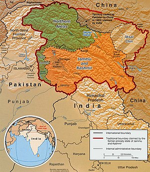
Sia La is a mountain pass situated on Saltoro Ridge, in Gilgit Baltistan, Pakistan some 60 km (37 mi) north-northwest of map point NJ9842 which defined the end of the 1972 Line of Control between India and Pakistan as part of the Simla Agreement. [1] Sia La sits near the Chinese border and immediately northwest of the upper part of the vast Siachen Glacier, connecting that glacier to the Pakistani-controlled Kondus Glacier and valley to the west.

Contents

The Saltoro Mountains Range, of which western slopes are held by Pakistan and separated by the Actual Ground Position Line (AGPL) the higher peaks and passes are held by India all of which remain snowbound throughout the year, provides access to Siachen Glacier to its east through five passes, i.e., listed from south to north are Chulung La (5,800m), Yarma La (6,100m), Gyong La (5,640m), Bilafond La (6,160m) - also called Saltoro La, and Sia La (7,300m). [2]

Geopolitical issues

Sia La, as well as nearby passes Bilafond La and Gyong La, saw military action starting in 1984 during Operation Meghdoot, the first military action of the Siachen conflict, itself being part of larger conflict, the Kashmir conflict. [3] Pakistan controls a pass just to the west that overlooks Sia La, named Conway Saddle which has Pakistan Army's Leghari Observation Post (Leghari OP) on the Actual Ground Position Line (AGPL).

See also

Near the AGPL (Actual Ground Position Line)
Borders
Conflicts
Operations
Other related topics

References

  1. The fight for Siachen
  2. Ghazanfar Ali and Hassan Akhtar Ghani, Siachen-The world's highest battlefield; Military Technology; Bonn Vol. 22, Iss. 3, (Mar 1998): S15-S17.
  3. Barua, Pradeep P. (30 June 2005). The State at War in South Asia (Studies in War, Society, and the Military). University of Nebraska Press. pp. 253–255. ISBN   978-0-8032-1344-9 . Retrieved 6 August 2009.

Citations