Rupin Pass

Last updated

Rupin Pass
Rupin Pass - View towards Sangla Valley.jpg
View from Rupin Pass
Elevation 4,650 m (15,250 ft)
Traversed byFrom Rupin Valley, Uttaranchal to Sangla Valley, Himachal Pradesh
Location India
Range Dhauladhar
Coordinates 31°20′41″N78°09′52″E / 31.344722°N 78.164444°E / 31.344722; 78.164444 Coordinates: 31°20′41″N78°09′52″E / 31.344722°N 78.164444°E / 31.344722; 78.164444
Himachal Pradesh relief map.svg
Red pog.svg

Rupin Pass is a high altitude pass across the Himalaya mountain range in state of Himachal pradesh India. It lies on a traditional shepherd and hiking route which starts from Dhaula in Uttarakhand and ends in Sangla in Himachal Pradesh. The path itself is located across mostly uninhabited areas in the Himalayan ranges at an elevation of 15,250 ft (4,650M) above sea level. [1] Sarasvati Glacier at Sarasvotri at this pass has been identified by some sources as the origin of paleo-river Sarasvati which turned in to icy waters at Netwar, flowing through Paonta Sahib and Adi Badri, Haryana, Punjab, Rajasthan and Gujarat. [2]

Contents

Description

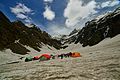
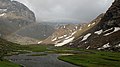
Rupin Pass trek consists of trails dug out of rock faces and wooden bridges, cut through deep dark folds in the mountain, glaciers and icy slopes, and over snow fields. Along the way there are white Rhododendrons and expanse of green meadows.

There are different trails that access the Rupin Pass. One of them starts at the sleepy village of Gosangu which is the last road head of Himachal Pradesh. Generally, trekkers and adventurers travel to Gosangu by road from Shimla via Rohru. The alternate route to Rupin Pass starts from Naitwar, which is accessible from Dehradhun via Dhaula. From either of the two road heads, the first camp is Jhaka, the hanging village and the last stop for replenishing stocks and a look at the civilization. Traveling the Rupin Pass is a moderate – difficult level of climbing. The trails follow the Rupin river all the way to the top (Upper waterfall camp).

Rupin pass is unique in a way that the ice melting on the one side of the pass forms the Rupin river that merges with Yamuna and eventually flows into the Bay of Bengal while the snow melting on the Sangla side of the pass merges into a stream the eventually flow into Sutlaj and hence flows into the Arabian sea.

Access

Rupin pass is at an altitude of 15250 ft above MSL and to reach here follow the Dhaula 5,100 ft to Gosangu 6,300 ft.11 km. Via Sewa – Gosangu 6,300 ft to Jhaka 8,700 ft.9 km Via Jiskun 7,600 ft. - Jhaka 8,700 ft to Saruwas thatch 11,150 ft. 6 km. Via Uduknal – Saruwas thatch 11,150 ft to thatch 11,680 ft (lower water fall camp) 6 km. - thatch 11,680 ft to the top of the Rupin waterfall 13,120 ft – thatch 11,680 ft to Rupin pass 15,250 ft

Related Research Articles

<span class="mw-page-title-main">Dhauladhar</span> Himalayan mountain range

Dhauladhar is a mountain range which is part of a lesser Himalayan chain of mountains. It rises from the Shivalik hills, to the north of Kangra and Mandi. Dharamsala, the headquarters of Kangra district and the winter capital of Himachal Pradesh, lies on its southern spur in the Kangra Valley. Chamba lies to the North of this range.

<span class="mw-page-title-main">Parvati Valley</span>

Parvati Valley is situated in the northern Indian state of Himachal Pradesh. From the confluence of the Parvati River with the River Beas, the Parvati Valley runs eastwards, through a steep-sided valley from the town of Bhuntar, in the Kullu district of Himachal Pradesh in Northern India.

<span class="mw-page-title-main">Bara-lacha la</span> Mountain pass in Himachal Pradesh, India

Bara-lacha la also known as Bara-lacha Pass, or Bārā Lācha La, is a high mountain pass in the Zanskar range of Northern-India, connecting Lahaul district in Himachal Pradesh to Leh district in Ladakh. Rail-cum-road tunnels are being constructed under the Bara-lacha la, Lungalacha La and Taglang La to cater for the traffic on existing NH3 Leh–Manali Highway & under-construction Bhanupli–Leh line.

Sangla is a town in the Baspa Valley, also referred to as the Sangla valley, in the Kinnaur District of Himachal Pradesh, India, close to the Tibetan border.

<span class="mw-page-title-main">Baspa Valley</span>

Baspa Valley is a river valley that is said to be named after the Baspa River. It lies in the Kinnaur District of Himachal Pradesh, India. Sangla is a major town in the Baspa Valley, and the valley is also known as the Sangla Valley or Tukpa Valley. The villages inside the valley is Chitkul, Rakchham, Batseri, Sangla, Kamru; the old capital of Bushahr State and Chansu.

<span class="mw-page-title-main">Everest base camps</span> Staging areas for mountaineering activities on Mount Everest

There are two base camps on Mount Everest, on opposite sides of the mountains: South Base Camp is in Nepal at an altitude of 5,364 metres (17,598 ft), while North Base Camp is in China at 5,150 metres (16,900 ft).

<span class="mw-page-title-main">Manimahesh Lake</span> Lake in Himachal Pradesh, India

Manimahesh Lake is a high altitude lake situated close to the Manimahesh Kailash Peak in the Pir Panjal Range of the Himalayas, in the Bharmour subdivision of Chamba district of the Indian state of Himachal Pradesh. The religious significance of this lake is next to that of the Lake Manasarovar in Tibet.

<span class="mw-page-title-main">Spiti</span> River valley in Himachal Pradesh

Spiti is a high-altitude region of the Himalayas, located in the north-eastern part of the northern Indian state of Himachal Pradesh. The name "Spiti" means "The middle land", i.e. the land between Tibet and India. Spiti incorporates mainly the valley of the Spiti River, and the valleys of several rivers that feed into the Spiti River. Some of the prominent side-valleys in Spiti are the Pin valley and the Lingti valley. Spiti is bordered on the east by Tibet, on the north by Ladakh, on the west and southwest by Lahaul, on the south by Kullu, and on the southeast by Kinnaur. Spiti has a cold desert environment. The valley and its surrounding regions are among the least populated regions of India. The Bhoti-speaking local population follows Tibetan Buddhism.

<span class="mw-page-title-main">Rivers in Himachal Pradesh</span>

Himachal Pradesh provides water to both the Indus and Ganges basins. The drainage systems of the region are the Chenab, the Ravi, the Beas, the Satluj and the Yamuna. These rivers are perennial and are fed by snow and rainfall. They are protected by an extensive cover of natural vegetation.

<span class="mw-page-title-main">Chitkul</span> Village in Kinnaur district, Himachal Pradesh, India

Chhitkul is a village in Kinnaur district of Himachal Pradesh. During winters, the place mostly remains covered with the snow and the inhabitants move to lower regions of Himachal.

<span class="mw-page-title-main">Suraj Tal</span> Lake in Himachal Pradesh, India

Suraj Tal, also called Tso Kamtsi or Surya Tal, is an 800 m (2,600 ft) long lake that lies just below the 4,890 m (16,040 ft) high Bara-lacha-la pass in Lahaul and Spiti district of the Indian state of Himachal Pradesh. It is the third highest lake in India, and the 21st-highest in the world. Suraj Tal Lake is just below the source of the Bhaga River that joins the Chandra River downstream at Tandi to form the Chandrabhaga River in Himachal Pradesh. The Chandrabhaga River is known as the Chenab as it enters the Jammu region of Jammu and Kashmir. The other major tributary of the Chandrabhaga, the Chandra originates and flows south-east of the Bara-lacha La.

<span class="mw-page-title-main">Saach Pass</span>

Sach Pass is a 4,414-metre-high (14,482 ft) mountain pass in Chamba District, Himachal Pradesh, India on the Pir Panjal range of the Himalayas. It is 127 km (79 mi) from the District Headquarters. It connects the Chamba valley with the Pangi valleys of Himachal Pradesh, India. There is a helipad on the ascent towards Sach pass from Bairagarh of Himachal Pradesh.

<span class="mw-page-title-main">Joginder Nagar Valley</span>

Joginder Nagar Valley is a valley in the Indian state of Himachal Pradesh. The valley contains the town of Joginder Nagar, Bir-Billing, Chauntra and various other hill resorts surrounded by mountains on all sides. The valley falls in the mid-hill zone of the Dhauladhar mountain range in the foothills of the Indian Himalayas. Geographically, the valley starts near Ghatta at its westernmost point and stretches south-eastwards up to Ghatasani, 15 kilometres from the main town. On an average, the valley is stretched 20 kilometres in length and 10 kilometers in width.

<span class="mw-page-title-main">Takling La</span>

Takling La is a parallel trek route through the Parana La (pass), located in the Himalayan Mountains. Parana La is the most famous trek route of Spiti and connects Kaza to Karzok. It has an altitude of 18,290 ft and follows the traditional trade route between Ladakh and Spiti Valley.

<span class="mw-page-title-main">Tourism in Himachal Pradesh</span> Tourism in the Indian state of Himachal Pradesh

Tourism in Himachal Pradesh relates to tourism in the Indian state of Himachal Pradesh. This is popularly renowned for its Himalayan landscapes and popular hill-stations. Many outdoor activities such as rock climbing, mountain biking, paragliding, ice-skating, trekking, rafting, and heli-skiing are popular tourist attractions in Himachal Pradesh.

Hamta Pass is a corridor in the Himalayas, between the Chandra Valley in Lahaul and the Kullu valley of Himachal Pradesh, India. The pass is named after Hamta Village, below Sethan village. Lower Himalayan shepherds use the pass in summer for its high altitude grasslands in the summer, when the desert of Lahaul is barren.

<span class="mw-page-title-main">Kalindi Pass</span> Highest and most adventurous trekking trail in India. Almost 6000M

Kalindi pass, or Kalindi khal is a high altitude mountain pass connecting Gangotri and Ghastoli. It is situated at 5,942 metres (19,495 ft) elevation and is arguably the most famous trekking pass of the Garhwal Himalaya. The pass is heavily glaciated. The glacier west of the pass flows into the Gangotri Glacier which forms the source of the Ganges.

<span class="mw-page-title-main">Bhaba Pass</span> Mountain pass in India

Bhaba Pass, also known as Bhawa Pass, is a high mountain pass situated in the northern Indian state of Himachal Pradesh in the Indian Himalayas. It is located on the border of Kinnaur district and Lahaul and Spiti District, and borders Pin Valley National Park and the Rupi-Bhaba Wildlife Sanctuary.

<span class="mw-page-title-main">Mud village, Spiti</span> Village in Himachal Pradesh, India

Mud is a small village in the cold desert region of Spiti in Himachal Pradesh, India. Located at an altitude of 3,810 m (12,500 ft) on the left bank of the Pin River, a right bank tributary of the Spiti River, the village nestles at the base of the Parbati range that towers almost vertically 1,600 m (5,200 ft) above. Mud is near the boundary of the Pin Valley National Park and is a convenient base for treks in the park, and to the neighbouring districts of Kullu and Kinnaur. It is the last village on the Spiti side of the Pin Parbati trek to Kullu and the Pin Bhaba trek to Kinnaur.

<span class="mw-page-title-main">Mane villages, Spiti</span> Twin villages in Spiti valley, Himachal Pradesh, India

Mane Kogma and Mane Yogma are two small villages on opposite banks of a nullah in the cold desert region of Spiti in Himachal Pradesh, India. The villages, at an altitude of 3,650 m (11,980 ft), are located on a small plateau about 200 m (660 ft) above the right bank of the Spiti River. Due to the lush green fields visible only after climbing the barren slope, the villages are referred to as the "hidden treasure".

References

  1. Cunningham, A. (1854). Ladák ... with notices of the surrounding countries. p. 71. Retrieved 13 June 2018.
  2. Haryana Samvad, Jan 2018.