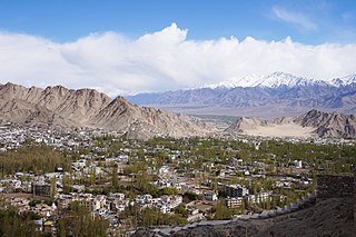
Leh is a city in Indian-administered Ladakh in the disputed Kashmir region. It is the largest city and the joint capital of Ladakh. Leh, located in the Leh district, was also the historical capital of the Kingdom of Ladakh. The seat of the kingdom, Leh Palace, the former residence of the royal family of Ladakh, was built in the same style and about the same time as the Potala Palace in Tibet. Since they were both constructed in a similar style and at roughly the same time, the Potala Palace in Tibet and Leh Palace, the royal residence, are frequently contrasted. Leh is at an altitude of 3,524 m (11,562 ft), and is connected via National Highway 1 to Srinagar in the southwest and to Manali in the south via the Leh-Manali Highway.
Rohtang Pass is a high mountain pass on the eastern end of the Pir Panjal Range of the Himalayas around 51 km (32 mi) from Manali in the Indian state of Himachal Pradesh. It connects the Kullu Valley with the Lahaul and Spiti Valleys of Himachal Pradesh, India.
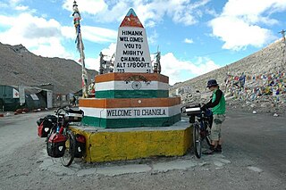
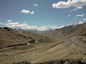
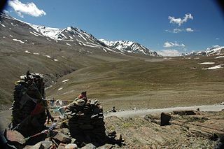
Chang La is a high mountain pass in Ladakh at an elevation of 5,391.3024 m (17,688.000 ft) in the Ladakh Range between Leh and the Shyok River valley. The Chang La, on Leh to Pangong Lake road, lies on the Leh-Karu-Sakti-Zingral-Chang La-Durbuk-Tangtse-Pangong Lake motorable road. Karu, which lies on Leh-Manali NH-3, connects Chang La and Pangong Lake to Leh and the rest of India. In September 2021, BRO opened another alternate motorable asphalt road between Zingral and Tangtse via Ke La pass and Taruk.
Leh district is a district in Indian-administered Ladakh in the disputed Kashmir-region. Ladakh is an Indian-administered union territory. With an area of 45,110 km2, it is the second largest district in the country, second only to Kutch. It is bounded on the north by Gilgit-Baltistan's Kharmang and Ghanche districts and Xinjiang's Kashgar Prefecture and Hotan Prefecture, to which it connects via the historic Karakoram Pass. Aksai Chin and Tibet are to the east, Kargil district to the west, and Lahul and Spiti to the south. The district headquarters is in Leh. It lies between 32 and 36 degree north latitude and 75 to 80 degree east longitude.
Bara-lacha la also known as Bara-lacha Pass, or Bārā Lācha La, is a high mountain pass in the Zanskar range of Northern-India, connecting Lahaul district in Himachal Pradesh to Leh district in Ladakh. Rail-cum-road tunnels are being constructed under the Bara-lacha la, at 4,750 metres (15,580 ft) high Lungalacha La and 5,184 metres (17,008 ft) high Taglang La to cater to the traffic on the existing NH3 Leh–Manali Highway and the under-construction Bhanupli–Leh line.

Tourism is one of the economic contributors to the union territory of Ladakh in Northern India. This union territory is located between the Karakoram mountain range to the north and the Himalayas to the south, and is situated at a height of 11,400 ft. Ladakh is composed of Leh and Kargil districts. The region contains prominent Buddhist sites and has an ecotourism industry.
Namika La is a high mountain pass in the Zaskar Range of the Himalayas in Ladakh, India, at an elevation of 3,700 m or 12,139 ft. It is traversed by the Srinagar-Leh highway.
Lachulung La, or Lāchālūng La or Lungalacha La, is a paved motorable mountain pass in Ladakh in India just north of border with Himachal Pradesh. It is located on the NH3 Leh–Manali Highway, 54 km (34 mi) north of Sarchu and 24 km (15 mi) west of Pang. Rail-cum-road tunnel is being constructed under this pass to cater for the traffic for existing NH3 & under-construction Bhanupli–Leh line, Bara-lacha la and Taglang La are other tunnels being constructed on this route.

Lamayuru or Yuru Monastery is a Tibetan Buddhist monastery in Lamayouro, Leh district, Ladakh, India. It is situated on the Srinagar-Leh highway 15 kilometres (9.3 mi) east of the Fotu La at a height of 3,510 metres (11,520 ft) and 19 km southwest of Khalsi.

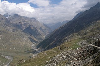
The Leh–Manali Highway is a 428 km (266 mi) long highway in northernmost India connecting Leh, the capital of the Union Territory of Ladakh, to Manali in the state of Himachal Pradesh. It crosses four passes: Rohtang La, Baralacha La, Lungalacha Ka, Tanglang La. It connects the Kullu Valley of the upper Beas river to the Chandra and Bhaga river valleys of Lahaul via the Atal tunnel in Himachal Pradesh, then crosses over a series of high Himalayan passes into the Indus river valley in Ladakh. It is usually open for about six months a year from the first week of May when the snow is cleared from the highway to October when snowfall again blocks the high passes on the highway. Before the construction of the Atal tunnel, the highway used to remain closed beyond the Rohtang Pass during winter. With the completion of the proposed Shingo La Tunnel on an alternate route through Zanskar valley, targeted to be completed by 2025, the whole Leh-Manali route will become an all-weather road.
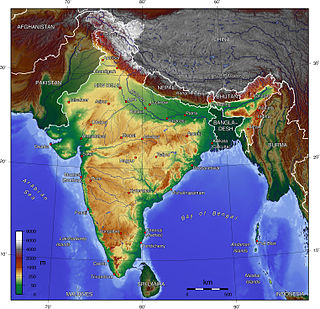
The Indian Himalayan Region is the section of the Himalayas within the Republic of India, spanning thirteen Indian states and union territories, namely Ladakh, Jammu and Kashmir, Himachal Pradesh, Uttarakhand, Sikkim, West Bengal, Manipur, Meghalaya, Mizoram, Nagaland, Tripura, Assam, and Arunachal Pradesh. The region is responsible for providing water to a large part of the Indian subcontinent and contains various flora and fauna.

National Highway 1D, also known as Srinagar–Leh Highway, was a National Highway in the state of Jammu and Kashmir that connected Srinagar to Leh in Ladakh. The Srinagar-Leh Highway was declared as National Highway in 2006. It is now part of National Highway 1 that extends west to Uri.
Military operations took place in Ladakh in 1948 during the conflict in Jammu and Kashmir between the Indian Army and Pakistani raiders infiltrated to capture the kingdom of Jammu and Kashmir. The eviction of this invading force of tribal raiders, who enjoyed numerical superiority, better lines of communication, commanding high ground and superior logistics, was a major military achievement for the small force of Indian soldiers.

Zoji La is a high mountain pass in the Himalayas. It is in the Kargil district, Indian Union territory of Ladakh. Located in the Dras subdivision, the pass connects the Kashmir Valley to its west with the Dras and Suru valleys to its northeast and the Indus valley further east. National Highway #1 between Srinagar and Leh in the western section of the Himalayan mountain range, traverses the pass. As of late 2022, an all-weather Zoji-la Tunnel is under construction to mitigate seasonal road blockages due to heavy snowfall.
All Ladakh Gonpa Association (ALGA) is the central organisation of the Buddhist monasteries in Ladakh, India. It aims to preserve and strengthen the monastic institutions. It was founded by the 19th Kushok Bakula Rinpoche in 1949 and he acted as its president for 41 years, from 1949 until 1991. In 1949, the first meeting of the great monasteries was held and ten monasteries took part. All Ladakh Gonpa Association was registered in 1959 and is run by a governing body consisting of fifteen lama members belonging to all four major schools of Tibetan Buddhism. There are sixteen major monastic institutions with hundreds of monks in each monastery.

National Highway 1 in India runs between the union territories of Jammu & Kashmir and Ladakh. It comprises parts of old NH1A and NH1D. The number 1 indicates, under the new numbering system, that it is the northernmost East-West highway in India.

National Highway 3, or NH 3, is a national highway in India. It starts from Atari adjacent to India-Pakistan border and near Amritsar and terminates at Leh in Ladakh, via Manali in Himachal Pradesh.
Chiling Sumda is a village in the Leh district of Ladakh, India. It is located Nimmu–Padum–Darcha road (NPDR) or Zanskar Highway in the Likir tehsil, on the bank of the Zanskar River in Zanskar region. It serves as a base camp for the Chadar Trek in the winters and is used to raft the Zanskar river in the summers.

Lamayouro is a village in the Leh district of Ladakh, India. The Lamayuru Monastery is located nearby. It is located in the Khalsi tehsil. The region is also referred to as ‘Moon Land’, due to its terrain's resemblance to the surface of the Moon.
Fotoksar or Photoksar is a village in the Leh district of Ladakh, India. It is located in the Khalsi tehsil.