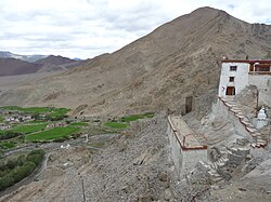
Nyoma

Last updated

Nyoma
Nyama, Neoma
Village
Nyoma Gompa.JPG
Nyoma's setting as seen from the gompa (Buddhist monastery)
India Ladakh location map UN view.svg
Red pog.svg
Nyoma
Location in Ladakh
India location map.svg
Red pog.svg
Nyoma
Nyoma (India)
Coordinates: 33°12′21″N78°38′54″E / 33.2059163°N 78.6483843°E / 33.2059163; 78.6483843
CountryFlag of India.svg India
Union territory Ladakh
District Leh
Tehsil Nyoma
Elevation
4,180 m (13,710 ft)
Population
 (2011)
  Total
918
Languages
  OfficialLhadakhi, Hindi, English
Time zone UTC+5:30 (IST)
PIN
194404
2011 census code901

Nyoma [a] is a principal village of southern Ladakh in India, the headquarters of an eponymous subdivision, tehsil, community development block and Indian Air Force Base in the Leh district. [4] [5] It is located on the bank of the Indus river after its 90-degree bend near Dungti east of Nyoma and before the valley narrows to a gorge near Mahe northwest of Nyoma. The Nyoma tehsil and subdivision cover all of southern Ladakh, including the Rupshu plains south of Nyoma, the Indus valley of Skakjung north of Nyoma, and the Hanle valley. Nyoma gompa , a Buddhist monastery, is located on the hill slope north of the village.

Contents

Geography

Nyoma Nyoma.jpg
Nyoma

The Indus river after its entry into Ladakh flows in a southwesterly direction after Demchok through [past Skakjung pastureland on it's right bank] a wide valley. Afterwards, at the northwestern end of Skakjung pastureland, it takes a 90-degree bend at Dungti blocked by the higher ground of the Chushul valley in the north. The village of Nyoma lies 33 km west of the bend on the right bank (northern bank), where it is also coupled with another neighbouring village Mood (or Mud or Mad). The Indus river here is said to be wide and shallow. It could be easily forded. [1] [6]

Nyoma is located 41 km southeast of Chumathang, [7] and 87 km south of Chushul. Nearby villages are Mahe and Loma. Hanle, the largest village in southern Ladakh, is 80 km to the southeast. Mount Sajum on the border with China is 43 km to the east.

Nyoma tehsil borders the Tibet Autonomous Region of China on the south and the east. The southern border runs along the Chumar village in Rupshu and the Imis Pass at the end of the Hanle valley. The eastern border, a Line of Actual Control resulting from the 1962 war with China, runs along the Kailash Range watershed of the Indus river till the village of Dumchele and narrows to the right bank of the Indus river up to Demchok.

The road from Leh runs till the village of Koyul, crossing the Indus river at Loma. From Koyul to Demchok, there is only a rough track. An alternative border road runs between the Koyul Lungpa valley and Demchok via the Umling La pass. [8] [9]

Military facilities

Nyoma Airbase

Nyoma hosts an Air Force Station at Mudh. [10] [11] The airbase is only 23 km (14 mi) away from the Line of Actual Control. [12] The airfield was originally established during 1962 India-China War. However, the unused airstrip was started serving as an advanced landing ground (ALG) to support fixed-wing aircraft operations from 18 September 2009. [13] [14]

The airstrip was upgraded to a full-fledged air base between August 2023 [15] to November 2025 under Project Himank with a budget of 218 crore (US$26 million) by the Border Roads Organisation (BRO). [16] [17]

The upgrade expanded the airstrip to a 1,235 acre an airbase capable of supporting fighter jet operations at 13,700 feet (4,200 m) elevation with an expanded 2.7 km (8,900 ft)-long, 46 m (151 ft)-wide runway paved runway along with allied military infrastructure. [18] The supporting infrastructure included ATC complex, hangar, crash bay, watch towers, and accommodation facilities. [19]

The Mudh-Nyoma Air Base was formerly inaugurated by the Chief of the Air Staff, Air Chief Marshal Amar Preet Singh, on 12 November 2025. [20] [21]

Field Firing Range

Nearby Nyoma is Indian Military's "Mahe Field Firing Range" (MFFR) on 1,259.25 ha (12.5925 km2) land inside the Changthang Wildlife Sanctuary. Firing range is 40–50 km (25–31 mi) from the disputed India-China Line of Actual Control. This is the one of its kind firing range in the entire Indian-held Ladakh region where all types of weapons can be fired. [22]

Tara Training Node Area

A 48.6 ha (486,000 m2) Training Node Area at Tara in the Changthang Wildlife Sanctuary will be constructed. [23]

Infrastructure

Roads

Roads infrastructure this area is being enhanced under the India-China Border Roads projects.

Telecommunication

Wildlife clearance was granted in 2022 for laying optical fiber cables in the Changthang Wildlife Sanctuary and Karakoram Wildlife Sanctuary for the internet and telephony connectivity. [22]

Tourism

Since 2010, foreign tourists with Inner Line Permits are permitted to visit Nyoma and its monastery.

Administration

Nyoma subdivision

Tsaga La pass. Tsaga La.jpg
Tsaga La pass.

The permanent civilian habitations under the administration of the Nyoma community development block (district subdivision) include villages like Nyoma, Hanle, Koyul, Demchok, Tsaga, Mudh, Rongo, Nyedar, etc. [24]

Nyoma village

According to the 2011 census of India, Nyoma has 202 households. The effective literacy rate (i.e. the literacy rate of population excluding children aged 6 and below) is 49.94%. [25]

Demographics (2011 census) [25]
TotalMaleFemale
Population918427491
Children aged below 6 years1256362
Scheduled caste 202
Scheduled tribe 707329378
Literates396198198
Workers (all)345212133
Main workers (total)16010060
Main workers: Cultivators402812
Main workers: Agricultural labourers615
Main workers: Household industry workers541
Main workers: Other1096742
Marginal workers (total)18511273
Marginal workers: Cultivators1394
Marginal workers: Agricultural labourers1196851
Marginal workers: Household industry workers404
Marginal workers: Others493514
Non-workers573215358

See also

Notes

  1. Variations of the spelling include "Nyama", [1] and "Neoma". [2] The village was referred to as "Nimu" or "Nima" during the British Raj period. [3] [1]

References

  1. 1 2 3 Gazetteer of Kashmir and Ladak (1890), p. 624.
  2. "New IAF airfield to be reopened in east Ladakh". The Economic Times. 6 April 2009. ISSN   0013-0389 . Retrieved 14 November 2025.
  3. Drew, The Jummoo and Kashmir Territories (1875), p. 313, footnote; p. 316.
  4. "Blockwise Village Amenity Directory" (PDF). Ladakh Autonomous Hill Development Council. Retrieved 23 July 2015.
  5. Leh subdivision-blocks.
  6. Schomberg, R. C. F. (1950), "Expeditionts: The Tso Morari to the Tibetan Frontier at Demchok", Himalayan Journal , XVI (1): 105
  7. Directions from Chumathang to Nyoma, distancesfrom.com, retrieved 15 November 2020.
  8. "BRO builds world's highest motorable road in Ladakh at 19,300 feet". Livemint. 2 November 2017. Archived from the original on 2 November 2017.
  9. "Achievements of West DTE during the F/Y 2016-17" (PDF). Border Roads Organisation. Archived (PDF) from the original on 7 November 2017.
  10. Singh, Rahul (12 November 2025). "IAF chief lands C-130J, inaugurates Nyoma airbase in Ladakh". Hindustan Times. Retrieved 14 November 2025.
  11. "All you need to know about Ladakh's Mudh-Nyoma airbase". The Times of India. 13 November 2025. ISSN   0971-8257 . Retrieved 14 November 2025.
  12. "IAF activates Nyoma airfield close to China border". The Indian Express. 18 September 2009. Retrieved 14 November 2025.
  13. Today, Headlines (18 September 2009). "IAF plane lands at Ladakh's Nyoma airfield". India Today. Retrieved 14 November 2025.
  14. Sharma, Vrinda (18 September 2009). "Joint effort by forces to operate in Leh-Ladakh". The Hindu. ISSN   0971-751X . Retrieved 14 November 2025.
  15. Peri, Dinakar (12 August 2023). "Nyoma advanced landing ground in eastern Ladakh being upgraded to handle fighter jets". The Hindu. ISSN   0971-751X . Retrieved 14 November 2025.
  16. Linganna, Girish (1 November 2025). "Built at –40°C! How India created the world's toughest airbase at Nyoma near the China border". Mathrubhumi. Retrieved 8 November 2025.
  17. "Ladakh airbase close to China border activated". The Times of India. 14 November 2025. ISSN   0971-8257 . Retrieved 14 November 2025.
  18. "To counter China, Nyoma airfield in Ladakh to be full-fledged base in 2 years". The Tribune. 5 January 2023. Retrieved 14 November 2025.
  19. "East Ladakh's Nyoma airfield set to be operational by October". The Times of India. 24 July 2025. ISSN   0971-8257 . Retrieved 27 July 2025.
  20. Singh, Rahul (12 November 2025). "IAF chief lands C-130J, inaugurates Nyoma airbase in Ladakh". Hindustan Times. Retrieved 14 November 2025.
  21. "All you need to know about Ladakh's Mudh-Nyoma airbase". The Times of India. 13 November 2025. ISSN   0971-8257 . Retrieved 14 November 2025.
  22. 1 2 "Central wildlife panel approves to upgrade IAF base near LAC in Ladakh". www.business-standard.com. Retrieved 12 September 2022.
  23. PTI (7 November 2025). "Wildlife panel clears 13 defence, paramilitary projects in Ladakh, Arunachal". The Hindu. ISSN   0971-751X . Retrieved 8 November 2025.
  24. Successive govts have neglected border areas of Ladakh: Nyoma's BDC chair, Economic Times, 24 June 2020.
  25. 1 2 "Leh district census". 2011 Census of India . Directorate of Census Operations. Retrieved 23 July 2015.

Bibliography

Commons-logo.svg Media related to Nyoma at Wikimedia Commons