Ghent Kangri was first climbed on 4 June 1961,by Wolfgang Axt,a member of an Austrian expedition led by Erich Waschak,via the West Ridge. He climbed solo above the high camp.
According to the Himalayan Index,there have been three subsequent ascents of the peak,in 1977,1980,and 1984.
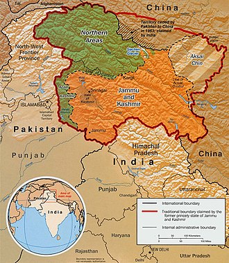
Indo-Pak mutually-agreed undisputed "International Border" (IB) in the black line,Indo-Pak "Line of Control" (LoC) in black dotted line in the north and west,Indo-Sino "Line of Actual" (LAC) in black dotted line in the east,Indo-Pak line across Siachen in north is "Actual Ground Position Line" (AGPL). The areas shown in green are the two Pakistani-controlled areas:Gilgit–Baltistan in the north and Azad Kashmir in the south. The area shown in orange is the Indian-controlled territories of Jammu and Kashmir,and Ladakh,and the diagonally-hatched area to the east is the Chinese-controlled area known as Aksai Chin. "Territories ceded by Pakistan to China claimed by India" in the north is Shaksgam (Trans-Karakoram Tract).United Nations map of Siachen Glacier showing "Point NJ980420" (Point NJ9842) as starting point of "Actual Ground Position Line" (AGPL),Goma military camp of Pakistan,Nubra River valley and Siachen glaciers held by India;Bilafond La and Sia La north of NJ9842 are also held by India. Masherbrum Range,Baltoro Glacier,Baltoro Glacier,Baltoro Muztagh and K2 are held by Pakistan.
This page is based on this Wikipedia article Text is available under the CC BY-SA 4.0 license; additional terms may apply. Images, videos and audio are available under their respective licenses.