K12 (mountain)

Last updated
K12
Ladakh relief map.svg
Red triangle with thick white border.svg
K12
K12 (Ladakh)
Gilgit-Baltistan relief map.svg
Red triangle with thick white border.svg
K12
K12 (Gilgit Baltistan)
Highest point
Elevation 7,428 m (24,370 ft) [1] [2]
Ranked 61st
Prominence 1,978 m (6,490 ft) [2]
Listing Ultra
Coordinates 35°17′42″N77°01′18″E / 35.29500°N 77.02167°E / 35.29500; 77.02167 [2]
Geography
Location Saltoro Ridge, Siachen, Actual Ground Position Line
Parent range Saltoro Mountains, Karakoram
Climbing
First ascent 1974 by Shinichi Takagi, Tsutomu Ito (Japanese)
Easiest route snow/ice climb

K12 is the second highest peak in the Saltoro Mountains, a subrange of the Karakoram range in the Siachen region of Ladakh. Its name comes from its designation given during the original survey of the Karakoram range. In 1984, an Indian army expedition under Colonel Prem Chand took hold of this peak, from the side of Siachen glacier by traversing from the west. [3]

Contents

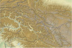
K12 lies to the southwest of the Siachen Glacier; the K12 glacier heads on its northeast slopes and feeds the Siachen. The western slopes of K12 drain to the Bilafond Glacier system, and thence to the Dansam River, and eventually the Indus River.

K12 was used for training for the Mount Everest expedition of the Indian Army in 1985. [4] Apart from this, K12 has seen little climbing activity, partly because of the unsettled political situation and the continued military presence in the area linked to the Siachen conflict. It was first attempted in 1960, after a reconnaissance visit by famed explorer Eric Shipton in 1957. After a further unsuccessful attempt by a Japanese party in 1971, another Japanese expedition put two climbers, Shinichi Takagi and Tsutomu Ito, on the summit. They fell and died on the descent, and their bodies were not recovered. Another Japanese expedition returned in 1975 and made the second ascent. [4]

See also

Related Research Articles

<span class="mw-page-title-main">Saser Kangri</span> Mountain in India

Saser Kangri is a mountain in India. It is the highest peak in the Saser Muztagh, the easternmost subrange of the Karakoram range. Sasir Kangri is located within Ladakh, the northernmost union territory in India.

<span class="mw-page-title-main">Siachen Glacier</span> Glacier located in the eastern Karakoram range in the Himalayas

The Siachen Glacier is a glacier located in the eastern Karakoram range in the Himalayas at about 35.421226°N 77.109540°E, just northeast of the point NJ9842 where the Line of Control between India and Pakistan ends. At 76 km (47 mi) long, it is the longest glacier in the Karakoram and second-longest in the world's non-polar areas. It falls from an altitude of 5,753 m (18,875 ft) above sea level at its head at Indira Col on the India–China border down to 3,620 m (11,875 ft) at its terminus. The entire Siachen Glacier, with all major passes, has been under the administration of India as part of the union territory of Ladakh, located in the Kashmir region since 1984. Pakistan maintains a territorial claim over the Siachen Glacier and controls the region west of Saltoro Ridge, lying west of the glacier, with Pakistani posts located 1 km below more than 100 Indian posts on the ridge.

<span class="mw-page-title-main">Trans-Karakoram Tract</span> Chinese-administered area in the northern half of Kashmir near the Shaksgam River

The Trans-Karakoram Tract, also known as the Shaksgam Tract, is a disputed area of approximately 5,200 km2 (2,000 sq mi) north of the Karakoram watershed, including the Shaksgam valley. The tract is administered by China as part of its Taxkorgan and Yecheng counties in the Xinjiang Uyghur Autonomous Region. Although the Shaksgam tract was never under the control of Pakistan since 1947, in the 1963 Sino-Pakistan Agreement, Pakistan recognized Chinese sovereignty over the Shaksgam tract, while China recognized Pakistani sovereignty over the Gilgit Agency, and a border based on actual ground positions was recognized as the international border by China and Pakistan. It, and the entire Kashmir region, is claimed by India.

<span class="mw-page-title-main">Saltoro Kangri</span> Mountain in disputed Kashmir region administered by India

Saltoro Kangri, previously known as Peak 36, stands as the highest peak within the Saltoro Mountains subrange, which is part of the larger Karakoram range. This subrange is also referred to as the Saltoro Range and is situated within the Karakoram region. The term "Saltoro Kangri" typically encompasses both of its twin peaks, Saltoro Kangri I and Saltoro Kangri II, which are connected by a saddle. When comparing heights, the generic term "Saltoro Kangri" is used for the taller of the two peaks, Saltoro Kangri I. This peak ranks as the 31st highest mountain globally and is located in the remote reaches of the Karakoram. It lies on the Actual Ground Position Line, dividing Indian-controlled territory in the Siachen region from Pakistani-controlled territory to the west of the Saltoro Range.

<span class="mw-page-title-main">Harish Kapadia</span> Indian mountain climber (born 1945)

Harish Kapadia is a Himalayan mountaineer, author and long-time editor of the Himalayan Journal from India. He has been awarded the Patron's Medal of the Royal Geographical Society, the Life Time Achievement Award for Adventure by the President of India and the King Albert Mountain Award presented by The King Albert I Memorial Foundation. He has written numerous books and articles on the Indian Himalayas. Harish was awarded the Piolets d'Or Asia Life Time Achievement Award in 2017 for his mountaineering and exploratory endeavors.

<span class="mw-page-title-main">Operation Meghdoot</span> 1984 Indian military operation to capture the Siachen Glacier in Kashmir

Operation Meghdoot was the codename for the Indian Armed Forces' operation to seize control of the Siachen Glacier in the then state of Jammu and Kashmir, precipitating the Siachen conflict. Executed in the morning of 13 April 1984 in the highest battlefield in the world, Meghdoot was the first military offensive of its kind. The operation preempted Pakistan's impending Operation Ababeel and was a success, resulting in Indian forces gaining control of the Siachen Glacier in its entirety.

<span class="mw-page-title-main">Saltoro Mountains</span> Subrange of the Karakoram located on the southwestern side of the Siachen Glacier in Kashmir

The Saltoro Mountains form a subrange within the Karakoram Range and are situated in the southeastern part of the Karakoram. They lie on the southwest side of the Siachen Glacier, which is one of the two longest glaciers in the world outside the polar regions. The name "Saltoro" is also associated with the Saltoro Valley, located west of this range and descending on the Pakistani side of the Saltoro Range, which generally follows the Actual Ground Position Line (AGPL).

The Rimo Muztagh is one of the most remote subranges of the Karakoram range. The southern part of Rimo Muztagh is in the Ladakh portion of far northwestern India, also claimed by Pakistan. The northern half, including the Rimo massif, is in the Siachen area. It is far from major towns, and close to the militarily sensitive Siachen Glacier, so it has seen little exploration or climbing activity compared to, for example, the nearby Baltoro Muztagh. The highest peak is Mamostong Kangri, 7,516 metres.

Mamostong Kangri or Mamostang Kangri, surveyed as K35, is the highest peak in the remote Rimo Muztagh, a subrange of the Karakoram range in Ladakh union territory of India. It is located about 30 km east-southeast of the snout of the Siachen Glacier. It is the 48th-highest independent peak in the world.

The Teram Kangri group is a mountain massif in the remote Siachen Muztagh, a subrange of the Karakoram range. The high point of the group, and of the Siachen Muztagh, is Teram Kangri I. The peak lies on the boundary between disputed China controlled Trans-Karakoram Tract and the disputed Siachen Glacier section controlled by India. The northeast side of the peak is in Chinese-controlled territory, the southwest side is controlled by India. Teram Kangri I was first climbed on August 10, 1975, by a Japanese expedition led by H. Katayama, which obtained a permit from the Government of Pakistan and made the long approach via Bilafond La. They climbed the SW ridge of Teram Kangri II and then took the East ridge to the top. Teram Kangri II was climbed on August 12 and 13 by six Japanese climbers.

<span class="mw-page-title-main">Ghent Kangri</span> Mountain in Pakistan/India

Ghent Kangri is a high peak near the north end of the Saltoro Mountains, a subrange of the Karakoram range. It is located west of the Siachen Glacier near the Actual Ground Position Line between India and Pakistan.

<span class="mw-page-title-main">Siachen conflict</span> 1984–2003 territorial conflict between India and Pakistan in Kashmir

The Siachen conflict, sometimes referred to as the Siachen Glacier conflict or the Siachen War, was a military conflict between India and Pakistan over the disputed 1,000-square-mile (2,600 km2) Siachen Glacier region in Kashmir. The conflict was started in 1984 by India's successful capture of the Siachen Glacier as part of Operation Meghdoot, and continued with Operation Rajiv in 1987. India took control of the 70-kilometre-long (43 mi) Siachen Glacier and its tributary glaciers, as well as all the main passes and heights of the Saltoro Ridge immediately west of the glacier, including Sia La, Bilafond La, and Gyong La. Pakistan controls the glacial valleys immediately west of the Saltoro Ridge. A cease-fire went into effect in 2003, but both sides maintain a heavy military presence in the area. The conflict has resulted in thousands of deaths, mostly due to natural hazards. External commentators have characterized it as pointless, given the perceived uselessness of the territory, and indicative of bitter stubbornness on both sides.

<span class="mw-page-title-main">Bilafond La</span> Mountain pass, Pakistan

Bilafond La (meaning "Pass of the Butterflies" in Balti language, also known as the Saltoro Pass, is a mountain pass situated on Saltoro Ridge, sitting immediately west of the vast Siachen Glacier, some 40 km directly north of map point NJ 980420 which defined the end of the 1972 Line of Control between Pakistan and India as part of the Simla Agreement. Bilafond La is on the ancient Silk Route linking the Indian Subcontinent and China.

<span class="mw-page-title-main">Sia La</span> Mountain pass in Ladakh

Sia La is a mountain pass situated on Saltoro Ridge, in Ladakh, India, some 60 km (37 mi) north-northwest of map point NJ9842 which defined the end of the 1972 Line of Control between India and Pakistan as part of the Simla Agreement. Sia La sits near the Chinese border and immediately northwest of the upper part of the vast Siachen Glacier, connecting that glacier to the Pakistani-controlled Kondus Glacier and valley to the west.

<span class="mw-page-title-main">Nubra River</span> River in India

The Nubra River is a river in the Nubra Valley of Ladakh in India. It is a tributary of the Shyok River and originates from the Siachen Glacier, the second-longest non-polar glacier in the world. In earlier Tibetan maps, it was referred as Yarma Tsangpo.

<span class="mw-page-title-main">Siachen Base Camp (India)</span>

Siachen Base Camp, 12,000 feet above sea level at Partapur, is a base camp of 102 Infantry Brigade of XIV Corps of Indian Army which protects 110 km long Actual Ground Position Line (AGPL) with at least 108 forward military outposts and artillery observation posts in the disputed region of Siachen Glacier in Ladakh Union Territory of India. It is approximately 6 hours drive north from the town of Leh via one of the highest vehicle-accessible passes in the world, Khardung La at 17,582 feet. Bana Top (20,500 ft) is the highest post in the region, which requires 80 km and 20 day trek for troops. Pahalwan Post and posts near Indira Col are other high posts. Kumar Post or Kumar Base, named after the Colonel Narendra "Bull" Kumar, serves as the battalion head quarter located 60 km from the Siachen base towards Indira Col. The Siachen Brigade consists of five to eight battalions of Ladakh Scouts supported by artillery, air defence, engineer and other logistic units. Pakistan has not been able to scale the crest of the Saltoro Range occupied by India. The temperature goes down to minus 86 °C during winters with icy 300 kmph blizzards. The average temperature is between minus 25 °C during day and minus 55 °C during the night.

<span class="mw-page-title-main">Actual Ground Position Line</span> Division line between Indian and Pakistani military posts on the Siachen Glacier in Kashmir

The Actual Ground Position Line (AGPL) divides current positions of Indian and Pakistani military posts and troops along the entire 110 kilometres (68 mi) long frontline in the disputed region of Siachen Glacier. AGPL generally runs along the Saltoro Mountains range, beginning from the northernmost point of the (LOC) at Point NJ 9842 and ending in the north on the Indira Ridge at the India-China-Pakistan LAC tripoint near Sia Kangri about 4 km (2.5 mi) northwest of Indira Col West, with peaks in excess of 7,000 m (23,000 ft) and temperatures ranging to around −55 °C (−67 °F). India gained control of 1,000 square miles (2,600 km2) of disputed territory in 1984 because of its military operations in Siachen. A cease-fire was announced in 2003.

NJ9842, also called NJ 980420, is the northernmost demarcated point of the India-Pakistan cease fire line in Kashmir known as the Line of Control (LoC). The India–Pakistan AGPL, begins from the NJ9842 on LoC and ends near the Indira Ridge at the trijunction of areas controlled by China, India, and Pakistan.

<span class="mw-page-title-main">Chumik Glacier</span> Glacier in Pakistan

Chumik Glacier is located in the Siachen region. Located on the west of Saltoro ridge, it is a 4-mile-long offshoot of the Bilafond Glacier.

<span class="mw-page-title-main">Saltoro Valley</span>

Saltoro valley is the highest valley in Pakistan and is located within the region of Baltistan. This valley is under the administration of Pakistan and is situated near the Saltoro Mountain Range which includes the prominent Saltoro Kangri peak and the Saltoro River. Saltoro Valley is in proximity to the Siachen Glacier, which is the world's highest battleground and a disputed territory between India and Pakistan.

References

  1. "Topographic map of K12". opentopomap.org. Retrieved 2023-06-19.
  2. 1 2 3 "High Asia I: The Karakoram, Pakistan Himalaya and India Himalaya (north of Nepal)". Peaklist.org. Retrieved 2014-05-27.
  3. Kapadia, Harish (1999). Across Peaks & Passes in Ladakh, Zanskar & East Karakoram. ISBN   9788173871009.
  4. 1 2 "Ascent of K12 (7428 m) in Saltoro Hills (Range)". Himalayan Journal. The Himalayan Club. 41. 1985. Retrieved 2020-06-15.

Sources