List of ultras of the Karakoram and Hindu Kush

Last updated

This is a list of all the ultra-prominent peaks (with topographic prominence greater than 1,500 metres) in the Karakoram, Hindu Kush and neighbouring ranges. The list includes 4 of the 14 8000m summits, all in the Karakoram, including the second highest mountain in the world, K2. There are a further 19 Ultras in the Karakoram and 5 in the Hindu Kush over 7,000m. The ultras of the Himalayas lie to the south east and are listed separately. To the north are the Pamirs, and to the east the mountains of Tibet.

Contents

Despite their height, only 3 mountains are among the 100 most prominent mountains, K2, in 22nd place, Tirich Mir (30) and Batura Sar (77). Two more are on the list of 120 most prominent mountains: Buni Zom (117) and Kuh-e Bandaka (118).

Karakoram

K2, Pakistan K2-big.jpg
K2, Pakistan
Masherbrum (K1), Pakistan Masherbrum.jpg
Masherbrum (K1), Pakistan
Muztagh Tower, Pakistan MuztaghTower.jpg
Muztagh Tower, Pakistan
NoPeakCountryElevation (m)Prominence (m)Col (m)
1 K2 Flag of Pakistan.svg  Pakistan  / Flag of the People's Republic of China.svg  China,8,6144,0204594
2 Batura Sar Flag of Pakistan.svg  Pakistan,7,7953,1184677
3 Rakaposhi Flag of Pakistan.svg  Pakistan,7,7882,8184970
4 Distaghil Sar Flag of Pakistan.svg  Pakistan,7,8852,5255360
5 Masherbrum Control by Flag of Pakistan.svg  Pakistan,7,8212,4575364
6 Saser Kangri Ladakh,Flag of India.svg  India 7,6722,3045368
7 Haramosh Peak Flag of Pakistan.svg  Pakistan,7,3972,2775120
8 Karun Kuh Flag of Pakistan.svg  Pakistan,6,9772,2404737
9 Malubiting Flag of Pakistan.svg  Pakistan,7,4532,1935260
10 Saltoro Kangri Flag of India.svg  India 7,7422,1605582
11 Gasherbrum I Flag of Pakistan.svg  Pakistan  / Flag of the People's Republic of China.svg  China;8,0802,1555925
12 Surukwat Kangri Flag of the People's Republic of China.svg  China 6,7921,9954797
13 K12 Flag of India.svg  India 7,4281,9785450
14 K6 Flag of Pakistan.svg  Pakistan,7,2821,9625320
15 The Crown Flag of the People's Republic of China.svg  China 7,2951,9195376
16 Baintha Brakk Flag of Pakistan.svg  Pakistan 7,285,1,8915394
17 Mamostong Kangri Flag of India.svg  India,7,5161,8035713
18 Khunyang Chhish Flag of Pakistan.svg  Pakistan,7,8521,7656087
19 Kharchanai Flag of the People's Republic of China.svg  China 6,4361,7434693
20 Muztagh Tower Flag of Pakistan.svg  Pakistan  / Flag of the People's Republic of China.svg  China 7,2761,7105566
21 Teram Kangri Flag of India.svg  India  / Flag of the People's Republic of China.svg  China 7,4641,7035761
22 Broad Peak Flag of Pakistan.svg  Pakistan  / Flag of the People's Republic of China.svg  China 8,0511,7016350
23 Mazar Shan Flag of the People's Republic of China.svg  China 6,5421,6744868
24 Kanjut Sar Flag of Pakistan.svg  Pakistan,7,7601,6606100
25 Chogolisa Flag of Pakistan.svg  Pakistan,7,6681,6246044
26 Bilchhar Dobani Flag of Pakistan.svg  Pakistan,6,1431,6014542
27 Kalmuk Kangri Flag of the People's Republic of China.svg  China 6,9521,6005352
28 Durbin Kangri Flag of the People's Republic of China.svg  China 6,8241,5795245
29 Kezhen Peak Flag of the People's Republic of China.svg  China 7,0381,5785460
30HP Marshakala Range Flag of Pakistan.svg  Pakistan,5,8281,5644264
31 Burnag Kangri Flag of the People's Republic of China.svg  China 6,8211,5295292
32 Gasherbrum II Flag of Pakistan.svg  Pakistan  / Flag of the People's Republic of China.svg  China 8,0341,5236511

Hindu Kush

NoPeakCountryElevation (m)Prominence (m)Col (m)
1 Tirich Mir Flag of Pakistan.svg  Pakistan 7,7063,9083798
2 Kuh-e Bandaka Flag of the Taliban.svg  Afghanistan 6,8122,8343978
3HP Kuh-e Safad Khers Flag of the Taliban.svg  Afghanistan 5,3252,4702855
4 Kuh-e Chuk Shakh Flag of the Taliban.svg  Afghanistan 5,4672,4443023
5 Noshaq Flag of the Taliban.svg  Afghanistan  / Flag of Pakistan.svg  Pakistan 7,4922,0245468
6 Saraghrar Flag of Pakistan.svg  Pakistan 7,3401,9795370
7 Kuh-e Fergardi Flag of the Taliban.svg  Afghanistan 5,0961,8503246
8 Shayaz Flag of Pakistan.svg  Pakistan 6,0261,7974229
9 Point 5120 Flag of the Taliban.svg  Afghanistan 5,1201,7753345
10 Kuh-e Shashgal Flag of the Taliban.svg  Afghanistan 6,2901,7584532
11 Udren Zom Flag of Pakistan.svg  Pakistan 7,1401,6205520
12 Shah Dhar Flag of the Taliban.svg  Afghanistan  / Flag of Pakistan.svg  Pakistan 7,0381,5625476
13 Lunkho e Dosare Flag of the Taliban.svg  Afghanistan  / Flag of Pakistan.svg  Pakistan 6,9011,5615340

South of the Khyber Pass

NoPeakCountryElevation (m)Prominence (m)Col (m)
1 Sikaram Sar Flag of the Taliban.svg  Afghanistan  / Flag of Pakistan.svg  Pakistan 4,7552,2952460
2HP Koh-i-Baba Flag of the Taliban.svg  Afghanistan 5,0482,1112937
3 Obasta Tsukai Flag of Pakistan.svg  Pakistan 3,4521,8131628
4 Ras Koh Flag of Pakistan.svg  Pakistan 3,0031,7971206
5 Shah Tus Aqa Ghar Flag of the Taliban.svg  Afghanistan 4,8031,7343069
6 Mizri Ghar Flag of Pakistan.svg  Pakistan 3,1111,6181493
7 Loe Nekan Flag of Pakistan.svg  Pakistan 3,5751,5971985
8 Kuh-e Soltan Saheb Flag of the Taliban.svg  Afghanistan 4,2701,5132757
9Kuh-e SefidFlag of the Taliban.svg  Afghanistan 4,7501,5103240

Hindu Raj

Buni Zom, Pakistan Buni Zom (2002).jpg
Buni Zom, Pakistan
NoPeakCountryElevation (m)Prominence (m)Col (m)
1 Buni Zom Flag of Pakistan.svg  Pakistan 6,5422,8453697
2 Koyo Zom Flag of Pakistan.svg  Pakistan 6,8722,5624310
3 Ghamubar Zom Flag of Pakistan.svg  Pakistan 6,5182,1334385
4 Chiantar Sar Flag of Pakistan.svg  Pakistan 6,4161,8414575
5 Shah Dok Flag of Pakistan.svg  Pakistan 6,3201,8154505
6 Thalo Zom Flag of Pakistan.svg  Pakistan 6,0501,7994251
7 Falak Sher Flag of Pakistan.svg  Pakistan 5,9181,5584360


Sources

Related Research Articles

<span class="mw-page-title-main">K2</span> 2nd-highest mountain on Earth

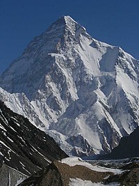
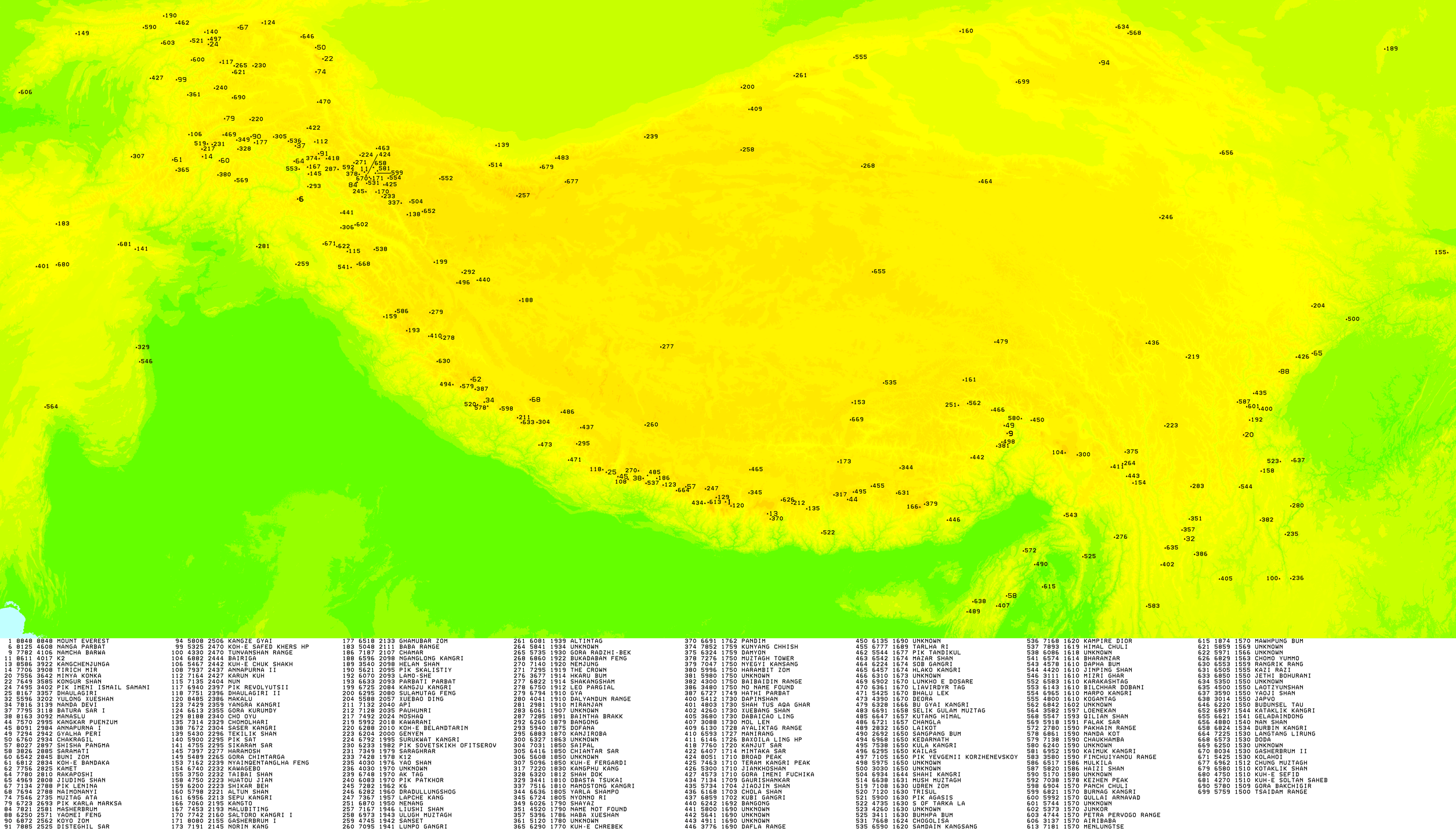
K2, at 8,611 metres (28,251 ft) above sea level, is the second-highest mountain on Earth, after Mount Everest at 8,849 metres (29,032 ft). It lies in the Karakoram range, partially in the Gilgit-Baltistan region of Pakistan-administered Kashmir and partially in the China-administered Trans-Karakoram Tract in the Taxkorgan Tajik Autonomous County of Xinjiang.

<span class="mw-page-title-main">Hindu Kush</span> Mountain range near the border of Afghanistan and Pakistan

The Hindu Kush is an 800-kilometre-long (500 mi) mountain range in Central and South Asia to the west of the Himalayas. It stretches from central and eastern Afghanistan into northwestern Pakistan and far southeastern Tajikistan. The range forms the western section of the Hindu Kush Himalayan Region (HKH); to the north, near its northeastern end, the Hindu Kush buttresses the Pamir Mountains near the point where the borders of Afghanistan, China, and Pakistan meet, after which it runs southwest through Pakistan and into Afghanistan near their border.

<span class="mw-page-title-main">Karakoram</span> Major mountain range spanning the borders between Pakistan, India and China

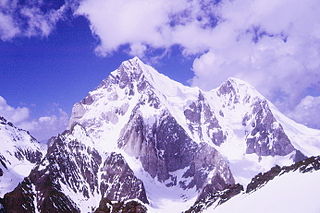
The Karakoram is a mountain range in the Kashmir region spanning the border of Pakistan, China, and India, with the northwestern extremity of the range extending to Afghanistan and Tajikistan. Most of the Karakoram mountain range falls under the jurisdiction of Gilgit-Baltistan, which is controlled by Pakistan. Its highest peak, K2, is located in Gilgit-Baltistan, Pakistan. It begins in the Wakhan Corridor (Afghanistan) in the west, encompasses the majority of Gilgit-Baltistan, Pakistan and extends into Ladakh and Aksai Chin.

<span class="mw-page-title-main">Muztagh Tower</span> Mountain in Pakistan and China

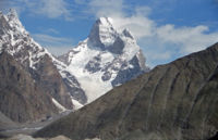
Muztagh Tower, also Mustagh Tower; Muztagh: icy mountain), is a mountain situated in Baltoro Muztagh, which is a segment of the Karakoram range. It straddles the border of the Gilgit–Baltistan region of Pakistan and the Xinjiang Uyghur Autonomous Region of China. Muztagh Tower is located between the basins of the Baltoro and Sarpo Laggo glaciers.

<span class="mw-page-title-main">Baintha Brakk</span> Mountain in Pakistan

Baintha Brakk or The Ogre is a steep, craggy mountain, 7,285 metres (23,901 ft) high, in the Panmah Muztagh, a subrange of the Karakoram mountain range. It is located in Gilgit-Baltistan, Pakistan. It is famous for being one of the hardest peaks in the world to climb: twenty-four years elapsed between the first ascent in 1977 and the second in 2001.

<span class="mw-page-title-main">Buni Zom</span>

The Buni Zom group is a prominent mountain area of Chitral, in the Hindu Raj range of Pakistan. Buni Zom (main) is the highest peak of the group with an elevation of 6,542 m (21,463 ft). It is located about 50 km (30 mi) northeast of the town of Chitral, and about 50 km (30 mi) east of Tirich Mir, the highest peak in the Hindu Kush.

<span class="mw-page-title-main">Falak Sar (Swat)</span>

Falak Sar is the highest mountain peak in Ushu Valley of Swat, Pakistan at an elevation of 5,957 metres (19,544 ft), it is considered the highest peak of the Swat district in the Hindu Kush mountains range, followed by Mankial mountain peak.

<span class="mw-page-title-main">Gilgit River</span> River in Pakistan

The Gilgit River is a tributary of the Indus River, flowing through various districts of Pakistan's Gilgit-Baltistan region, including Gupis-Yasin, Ghizer and Gilgit districts. The Gilgit River originates from Shandur Lake and proceeds to join the Indus River near the towns of Juglot and Bunji. This confluence is believed to mark the meeting point of three prominent mountain ranges: the Hindu Kush, the Himalayas, and the Karakoram.

<span class="mw-page-title-main">Batura Sar</span> Mountain in Pakistan

Batura Sar, also referred to as Batura I, is the 25th-highest mountain on Earth and the 10th-highest in Pakistan. It is the highest peak of the Batura Muztagh, which is the westernmost subrange of the Karakoram range. It forms the apex of the Batura Wall, a continuously high part of the backbone of the Batura Muztagh.

Mamostong Kangri or Mamostang Kangri, surveyed as K35, is the highest peak in the remote Rimo Muztagh, a subrange of the Karakoram range in Ladakh union territory of India. It is located about 30 km east-southeast of the snout of the Siachen Glacier. It is the 48th-highest independent peak in the world.

<span class="mw-page-title-main">Geography of Gilgit-Baltistan</span>

Gilgit-Baltistan is an administrative territory of Pakistan in the northern part of the country. It was given self-governing status on August 29, 2009. Gilgit-Baltistan comprises 14 districts within three divisions. The four districts of Skardu Kharmang Shigar and Ghanche are in the Baltistan Division, four districts of Gilgit Ghizer Hunza and Nagar districts which were carved out of Gilgit District are in the Gilgit Division and the third division is Diamir, comprising Chilas and Astore. The main political centres are the towns of Gilgit and Skardu.

<span class="mw-page-title-main">Skyang Kangri</span> Mountain in Pakistan and China

Skyang Kangri, or Staircase Peak, is a high mountain peak of the Baltoro Muztagh, a subrange of the Karakoram range. It lies on the Pakistan–China border, about 7 kilometres (4.3 mi) northeast of K2, the world's second-highest mountain. The name "Staircase Peak" refers to the East Ridge, which resembles a giant staircase with five steps.

<span class="mw-page-title-main">Koyo Zom</span>

Koyo Zom is the highest peak in the Hindu Raj mountain range at 6,872 metres (22,546 ft). The Hindu Raj mountain range sits between the Hindu Kush in the west and the Karakoram in the east.

Wojciech Kurtyka is a Polish mountaineer and rock climber, one of the pioneers of the alpine style of climbing the biggest walls in the Greater Ranges. He lived in Wrocław up to 1974 when he moved to Kraków. He graduated as engineer in electronics. In 1985 he climbed the "Shining Wall," the west face of Gasherbrum IV, which Climbing magazine declared to be the greatest achievement of mountaineering in the twentieth century. In 2016, he received the Piolet d'Or for lifetime achievement in mountaineering.

<span class="mw-page-title-main">Ultra-prominent peak</span> Mountain with prominence of 1,500 metres

An ultra-prominent peak, or ultra for short, is a mountain summit with a topographic prominence of 1,500 metres (4,900 ft) or more; it is also called a P1500. The prominence of a peak is the minimum height of climb to the summit on any route from a higher peak, or from sea level if there is no higher peak. There are approximately 1,524 such peaks on Earth. Some well-known peaks, such as the Matterhorn and Eiger, are not ultras because they are connected to higher mountains by high cols and thus do not achieve enough topographic prominence.

Lunkho e Dosare is a mountain in the Hindu Kush mountains. It has an elevation of 6,901 metres (22,641 ft) and sits on the international boundary between Afghanistan and Pakistan.