Mount Markham is a twin-peaked massif surmounting the north end of Antarctica's Markham Plateau. The main peak has an elevation of 4,350 metres (14,272 ft) and the lower sub-peak is 4,280 metres (14,042 ft) high. Discovered by the British National Antarctic Expedition of 1901–1904), it is named for Sir Clements Markham, who, as President of the Royal Geographical Society, planned the expedition and chose Robert Falcon Scott as its leader. Mount Markham is the fourth-highest ultra prominent peak in Antarctica.
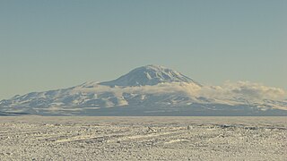
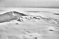
Mount Discovery is a conspicuous, isolated stratovolcano, lying at the head of McMurdo Sound and east of Koettlitz Glacier, overlooking the NW portion of the Ross Ice Shelf. It forms the center of a three-armed mass of which Brown Peninsula is one extension to the north; Minna Bluff is a second to the east; the third is Mount Morning to the west. Mount Discovery was discovered by the British National Antarctic Expedition (1901–04) and named for their expedition ship Discovery.

Mount Siple is a potentially active Antarctic shield volcano, rising to 3,110 metres (10,203 ft) and dominating the northwest part of Siple Island, which is separated from the Bakutis Coast, Marie Byrd Land, by the Getz Ice Shelf. Its youthful appearance strongly suggests that it last erupted in the Holocene. It is capped by a 4-by-5-kilometre summit caldera, and tuff cones lie on the lower flanks. Recely Bluff is on the northeast slope of the mountain, about 7 nautical miles (13 km) from the peak. Its volume of 1,800 cubic kilometres (430 cu mi) is comparable to that of Mount Erebus.
Mount Ragang, also called Mount Piapayungan and Blue Mountain by the local people, is an active stratovolcano on Mindanao island in the Philippines. With an elevation of 2,815 metres (9,236 ft), it is the seventh highest mountain in the Philippines and the highest point in Lanao del Sur.
Mount McClintock is the highest mountain in the Britannia Range in Antarctica, surmounting the south end of Forbes Ridge, ten kilometres (6 mi) east of Mount Olympus. It was discovered by the Discovery expedition (1901–04) and named for Admiral Sir Leopold McClintock, Royal Navy, a member of the Ship Committee for the expedition.

Mount Catherine, locally known as Gabal Katrîne, is the highest mountain in Egypt. It is located near the town of Saint Catherine in the South Sinai Governorate.
Mount Arlan is an 1,880-metre (6,168 ft) peak in the western plains of Turkmenistan in Balkan Province. Mount Arlan stands about 2,000 metres above the shore of the below-sea level Caspian Sea. It is the highest summit of the Uly Balkan range.

An ultra-prominent peak, or ultra for short, is a mountain summit with a topographic prominence of 1,500 metres (4,900 ft) or more; it is also called a P1500. The prominence of a peak is the minimum height of climb to the summit on any route from a higher peak, or from sea level if there is no higher peak. There are approximately 1,524 such peaks on Earth. Some well-known peaks, such as the Matterhorn and Eiger, are not ultras because they are connected to higher mountains by high cols and therefore do not achieve enough topographic prominence.
Mount Supernal is a large double summit mountain surmounting the southeast corner of Hercules Neve and the heads of the Gair and Meander Glaciers, in Victoria Land, Antarctica. The feature has at times been mistaken for Mount Murchison. Named by the northern party of New Zealand Geological Survey Antarctic Expedition (NZGSAE), 1962–63, because of its prominent and lofty appearance.

Mount Lister is a massive mountain, 4,025 metres (13,200 ft) high, forming the highest point in the Royal Society Range of Victoria Land, Antarctica. It was discovered by the British National Antarctic Expedition (1901–1904) which named it for Lord Joseph Lister, President of the Royal Society, 1895–1900.

The Cordillera Central is the highest mountain range in the Dominican Republic and in all of the Caribbean, running through the heart of the island of Hispaniola.
Mount Kalatungan, also known as Catatungan, is a volcanic mountain located in the province of Bukidnon in the southern Philippines. It is a stratovolcano with no known historical eruptions and classified by the Philippine Institute of Volcanology and Seismology (PHIVOLCS) as a potentially active volcano.

Pizzo Coca is a mountain that straddles the Val Seriana and the Valtellina in Lombardy, Italy. It is the highest peak in the Bergamo Alps. Its height is 3,050 metres with a prominence height of 1,878 metres and a saddle of 1,172 metres. A post-glacial valley exists near a point called Ometto in sassi at 2,400 meters.
Mount Gaudry is a mountain, 2,315 metres (7,600 ft) high, rising close southwest of Mount Barre and 5 nautical miles (9 km) north-northwest of Mount Liotard in the southern part of Adelaide Island, Antarctica. It was discovered by the French Antarctic Expedition, 1903–05, under Jean-Baptiste Charcot, who named it after Albert Gaudry, a prominent French paleontologist.
Mount Verne is a mountain standing 6 nautical miles (11 km) east of Bongrain Point and dominating the south part of Pourquoi Pas Island, off the west coast of Graham Land. It was first sighted and roughly surveyed in 1909 by the French Antarctic Expedition under Charcot, and then resurveyed in 1948 by the Falkland Islands Dependencies Survey (FIDS). It was named by them for Jules Verne, the author of Twenty Thousand Leagues Under the Sea. Other features on Pourquoi Pas Island are named after characters in this book.

Mount Murchison is a mountain in Victoria Land, Antarctica. Sources differ as to whether Murchison is the highest peak of the Mountaineer Range; or the second highest if Mount Supernal is considered part of the range.

Çikë, at 2,044 metres (6,706 ft) above sea level, is the highest peak of the Ceraunian Mountains range in Albania which extends approximately 100 kilometres (62 mi) along the Albanian Riviera in a northwesterly direction from Sarandë to the Karaburun Peninsula. With a prominence of 1,563 metres (5,128 ft), Çikë is the 85th most prominent mountain peak in Europe.