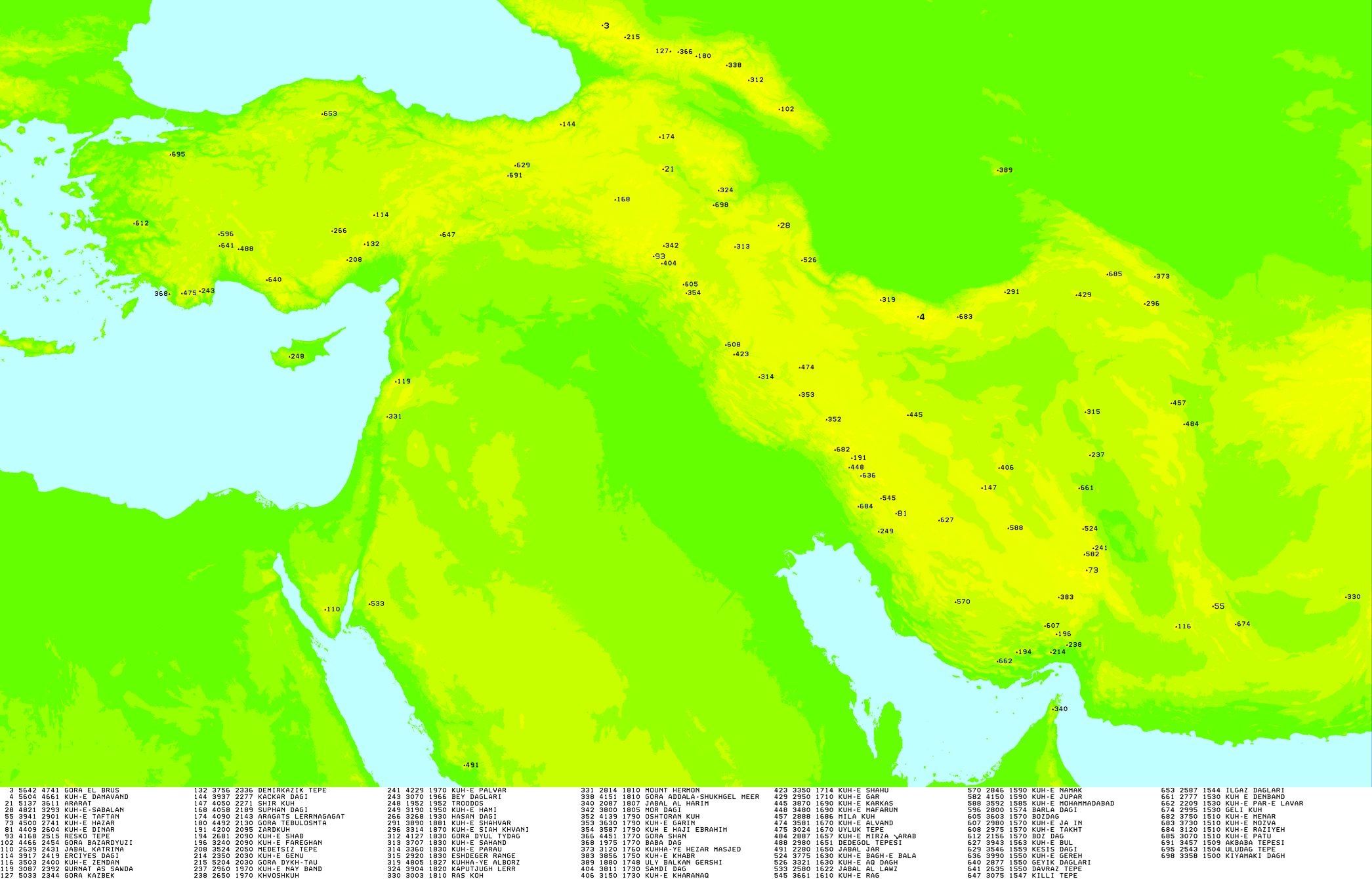
This is a list of all 101 of the ultra-prominent peaks (with topographic prominence greater than 1,500 metres) in West Asia. It includes peaks on the islands of Cyprus and Socotra. It also includes the 10 ultras of the Caucasus (also listed under Europe) as they are geographically more connected to the mountains of West Asia. Two of these peaks (Mount Aragats and Kapudzhukh Lerr) are on the Asian side of the ridge of the Greater Caucasus, which forms the boundary between Asia and Europe, and four more are on the border itself and so in both Europe and Asia.
The Arabian Sea is a region of sea in the northern Indian Ocean, bounded on the west by the Arabian Peninsula, Gulf of Aden and Guardafui Channel, on the northwest by Gulf of Oman and Iran, on the north by Pakistan, on the east by India, and on the southeast by the Laccadive Sea and the Maldives, on the southwest by Somalia. Its total area is 3,862,000 km2 (1,491,000 sq mi) and its maximum depth is 5,395 meters. The Gulf of Aden in the west connects the Arabian Sea to the Red Sea through the strait of Bab-el-Mandeb, and the Gulf of Oman is in the northwest, connecting it to the Persian Gulf.
The Gulf of Oman or Sea of Oman, also known as Gulf of Makran or Sea of Makran, is a gulf in the Indian Ocean that connects the Arabian Sea with the Strait of Hormuz, which then runs to the Persian Gulf. It borders Iran and Pakistan on the north, Oman on the south, and the United Arab Emirates on the west.
The Middle East is a geopolitical region encompassing the Arabian Peninsula, the Levant, Turkey, Egypt, Iran, and Iraq.
The Caucasus or Caucasia, is a region spanning Eastern Europe and Western Asia. It is situated between the Black Sea and the Caspian Sea, mainly comprising Armenia, Azerbaijan, Georgia, and parts of Southern Russia. The Caucasus Mountains, including the Greater Caucasus range, have conventionally been considered as a natural barrier between Europe and Asia, bisecting the Eurasian landmass.
The Arab world, formally the Arab homeland, also known as the Arab nation, the Arabsphere, or the Arab states, comprises a large group of countries, mainly located in West Asia and North Africa. While the majority of people in the Arab world are ethnically Arab, there are also significant populations of other ethnic groups such as Berbers, Kurds, Somalis and Nubians, among other groups. Arabic is used as the lingua franca throughout the Arab world.
The Caucasus Mountains is a mountain range at the intersection of Asia and Europe. Stretching between the Black Sea and the Caspian Sea, they are surrounded by the Caucasus region and are home to Mount Elbrus, the highest peak in Europe at 5,642 metres (18,510 ft) above sea level.
The Iranian plateau or Persian plateau is a geological feature spanning parts of the Caucasus, Central Asia, South Asia, and West Asia. It makes up part of the Eurasian plate, and is wedged between the Arabian plate and the Indian plate. The plateau is situated between the Zagros Mountains to the west, the Caspian Sea and the Köpet Dag to the north, the Armenian Highlands and the Caucasus Mountains to the northwest, the Strait of Hormuz and the Persian Gulf to the south, and the Indian subcontinent to the southeast.
West Asia, also called Western Asia or Southwest Asia, is the westernmost region of Asia. As defined by most academics, UN bodies and other institutions, the subregion consists of Anatolia, the Arabian Peninsula, Iran, Mesopotamia, the Armenian highlands, the Levant, the island of Cyprus, the Sinai Peninsula and the South Caucasus. The region is separated from Africa by the Isthmus of Suez in Egypt, and separated from Europe by the waterways of the Turkish Straits and the watershed of the Greater Caucasus. Central Asia lies to its northeast, while South Asia lies to its east. Twelve seas surround the region (clockwise): the Aegean Sea, the Sea of Marmara, the Black Sea, the Caspian Sea, the Persian Gulf, the Gulf of Oman, the Arabian Sea, the Gulf of Aden, the Red Sea, the Gulf of Aqaba, the Gulf of Suez, and the Mediterranean Sea. West Asia contains the majority of the similarly defined Middle East. The Middle East is a political term that has changed many times depending on political and historical context while West Asia is a geographical term with more consistency. It excludes most of Egypt and the northwestern part of Turkey, and includes the southern part of the Caucasus.
A subregion is a part of a larger geographical region or continent. Cardinal directions are commonly used to define subregions. There are many criteria for creating systems of subregions; this article is focusing on the United Nations geoscheme, which is a changing, constantly updated, UN tool based on specific political geography and demography considerations relevant in UN statistics.
Geography of Asia reviews geographical concepts of classifying Asia, comprising 58 countries and territories.
The Middle East and North Africa (MENA), also referred to as West Asia and North Africa (WANA) or South West Asia and North Africa (SWANA), is a geographic region which comprises the Middle East and North Africa together. However, it is widely considered to be a more defined and apolitical alternative to the concept of the Greater Middle East, which comprises the bulk of the Muslim world. The region has no standardized definition and groupings may vary, but the term typically includes countries like Algeria, Bahrain, Egypt, Jordan, Kuwait, Lebanon, Libya, Morocco, Oman, Qatar, Saudi Arabia, Syria, Tunisia, the UAE, and Yemen.
Greater Iran or Greater Persia, also called the Iranosphere or the Persosphere, is an expression that denotes a wide socio-cultural region comprising parts of West Asia, the Caucasus, Central Asia, South Asia, and East Asia —all of which have been affected, to some degree, by the Iranian peoples and the Iranian languages.
This is a list of international, national and subnational flags used in Asia.
The geology of Turkey is the product of a wide variety of tectonic processes that have shaped Anatolia over millions of years, a process which continues today as evidenced by frequent earthquakes and occasional volcanic eruptions.
Cimmeria was an ancient continent, or, rather, a string of microcontinents or terranes, that rifted from Gondwana in the Southern Hemisphere and was accreted to Eurasia in the Northern Hemisphere. It consisted of parts of present-day Turkey, Iran, Afghanistan, Pakistan, Tibet, China, Myanmar, Thailand, and Malaysia. Cimmeria rifted from the Gondwanan shores of the Paleo-Tethys Ocean during the Early Permian and as the Neo-Tethys Ocean opened behind it, during the Permian, the Paleo-Tethys closed in front of it. Because the different chunks of Cimmeria drifted northward at different rates, a Meso-Tethys Ocean formed between the different fragments during the Cisuralian. Cimmeria rifted off Gondwana from east to west, from Australia to the eastern Mediterranean. It stretched across several latitudes and spanned a wide range of climatic zones.
The United Nations geoscheme for Asia is an internal tool created and used by the United Nations, maintained by the United Nations Statistics Division (UNSD) for the specific purpose of UN statistics. The scheme's subregions are presented here in alphabetical order. Its subregions may not coincide with other geographic categorization schemes.
Ethnic groups in the Middle East are ethnolinguistic groupings in the "transcontinental" region that is commonly a geopolitical term designating the intercontinental region comprising West Asia without the South Caucasus, and also comprising Egypt in North Africa. The Middle East has historically been a crossroad of different cultures and languages. Since the 1960s, the changes in political and economic factors have significantly altered the ethnic composition of groups in the region. While some ethnic groups have been present in the region for millennia, others have arrived fairly recently through immigration. The largest socioethnic groups in the region are Egyptians, Arabs, Turks, Persians, Kurds, and Azerbaijanis but there are dozens of other ethnic groups that have hundreds of thousands, and sometimes millions of members.
Eastern Mediterranean is a loose definition of the eastern approximate half, or third, of the Mediterranean Sea, often defined as the countries around the Levantine Sea.