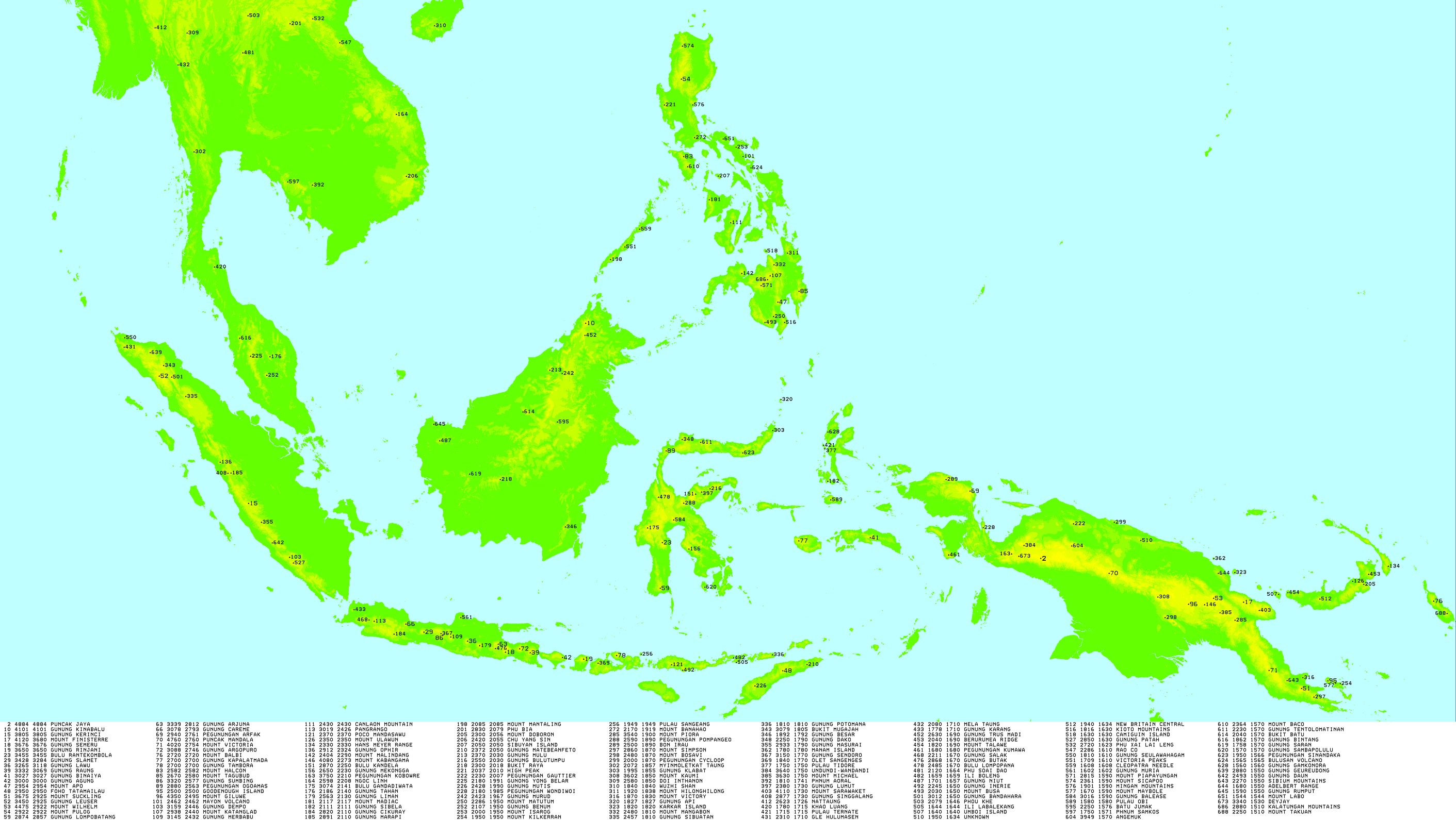
List of ultras of the Malay Archipelago

Last updated

This is a list of ultra prominent peaks (with topographic prominence greater than 1,500 metres) in the Malay Archipelago, a group of over 25,000 islands which includes Brunei, Singapore, East Malaysia, Indonesia, the Philippines and East Timor. However, this list excludes ultras in the Philippines which are listed separately.

Contents

Sumatra

Mount Singgalang, Indonesia Singgalang.jpg
Mount Singgalang, Indonesia
NoPeakCountryElevationProminenceCol
1 Mount Kerinci Flag of Indonesia.svg  Indonesia (Sumatra)3,805 m
12,484 ft
3,805 m
12,484 ft
0
2 Mount Leuser Flag of Indonesia.svg  Indonesia (Sumatra)3,466 m
11,371 ft
2,891 m
9,485 ft
525
3 Mount Dempo Flag of Indonesia.svg  Indonesia (Sumatra)3,159 m
10,364 ft
2,446 m
8,025 ft
713
4 Mount Ophir Flag of Indonesia.svg  Indonesia (Sumatra)2,912 m
9,554 ft
2,324 m
7,625 ft
588
5 Mount Marapi Flag of Indonesia.svg  Indonesia (Sumatra)2,891 m
9,485 ft
2,116 m
6,942 ft
775
6 Bukit Mugajah Flag of Indonesia.svg  Indonesia (Sumatra)3,079 m
10,102 ft
1,805 m
5,922 ft
1274
7 Mount Sibuatan Flag of Indonesia.svg  Indonesia (Sumatra)2,457 m
8,061 ft
1,802 m
5,912 ft
655
8 Mount Masurai Flag of Indonesia.svg  Indonesia (Sumatra)2,933 m
9,623 ft
1,791 m
5,876 ft
1142
9 Mount Singgalang Flag of Indonesia.svg  Indonesia (Sumatra)2,877 m
9,439 ft
1,727 m
5,666 ft
1150
10 Gle Hulumasen Flag of Indonesia.svg  Indonesia (Sumatra)2,310 m
7,580 ft
1,720 m
5,640 ft
590
11 Mount Bandahara Flag of Indonesia.svg  Indonesia (Sumatra)3,012 m
9,882 ft
1,644 m
5,394 ft
1368
12 Mount Patah Flag of Indonesia.svg  Indonesia (Sumatra)2,850 m
9,350 ft
1,635 m
5,364 ft
1215
13 Seulawah Agam Flag of Indonesia.svg  Indonesia (Sumatra)1,810 m
5,940 ft
1,610 m
5,280 ft
200
14 Geureudong Flag of Indonesia.svg  Indonesia (Sumatra)2,880 m
9,450 ft
1,546 m
5,072 ft
1334
15 Bukit Daun Flag of Indonesia.svg  Indonesia (Sumatra)2,493 m
8,179 ft
1,541 m
5,056 ft
952

Java

Semeru, Indonesia Semeru.jpg
Semeru, Indonesia
Mount Sumbing, Indonesia Mount sumbing.jpg
Mount Sumbing, Indonesia
NoPeakCountryElevationProminenceCol
1 Semeru Flag of Indonesia.svg  Indonesia (Java)3,676 m
12,060 ft
3,676 m
12,060 ft
0
2 Mount Slamet Flag of Indonesia.svg  Indonesia (Java)3,428 m
11,247 ft
3,284 m
10,774 ft
144
3 Mount Lawu Flag of Indonesia.svg  Indonesia (Java)3,265 m
10,712 ft
3,118 m
10,230 ft
147
4 Raung Flag of Indonesia.svg  Indonesia (Java)3,332 m
10,932 ft
3,069 m
10,069 ft
263
5 Arjuno-Welirang Flag of Indonesia.svg  Indonesia (Java)3,339 m
10,955 ft
2,812 m
9,226 ft
527
6 Mount Cereme Flag of Indonesia.svg  Indonesia (Java)3,078 m
10,098 ft
2,793 m
9,163 ft
285
7 Iyang-Argapura Flag of Indonesia.svg  Indonesia (Java)3,088 m
10,131 ft
2,746 m
9,009 ft
342
8 Mount Sumbing Flag of Indonesia.svg  Indonesia (Java)3,371 m
11,060 ft
2,577 m
8,455 ft
743
9 Mount Merbabu Flag of Indonesia.svg  Indonesia (Java)3,145 m
10,318 ft
2,432 m
7,979 ft
713
10 Mount Pangrango Flag of Indonesia.svg  Indonesia (Java)3,019 m
9,905 ft
2,426 m
7,959 ft
593
11 Mount Liman Flag of Indonesia.svg  Indonesia (Java)2,563 m
8,409 ft
2,131 m
6,991 ft
432
12 Mount Cikuray Flag of Indonesia.svg  Indonesia (Java)2,820 m
9,250 ft
2,103 m
6,900 ft
717
13 Mount Sundoro Flag of Indonesia.svg  Indonesia (Java)3,150 m
10,330 ft
1,760 m
5,770 ft
1390
14 Gunung Karang Flag of Indonesia.svg  Indonesia (Java)1,778 m
5,833 ft
1,703 m
5,587 ft
75
15 Mount Salak Flag of Indonesia.svg  Indonesia (Java)2,211 m
7,254 ft
1,678 m
5,505 ft
533
16 Mount Butak Flag of Indonesia.svg  Indonesia (Java)2,868 m
9,409 ft
1,675 m
5,495 ft
1193
17 Mount Muria Flag of Indonesia.svg  Indonesia (Java)1,602 m
5,256 ft
1,595 m
5,233 ft
7

Lesser Sunda Islands

Mount Rinjani, Indonesia Rinjani 1994.jpg
Mount Rinjani, Indonesia
Tatamailau, East Timor Tatamailau2.jpg
Tatamailau, East Timor
NoPeakCountryElevationProminenceCol
1 Mount Rinjani Flag of Indonesia.svg  Indonesia (Lombok)3,726 m
12,224 ft
3,726 m
12,224 ft
0
2 Mount Agung Flag of Indonesia.svg  Indonesia (Bali)3,031 m
9,944 ft
3,031 m
9,944 ft
0
3 Tatamailau Flag of East Timor.svg  Timor-Leste 2,986 m
9,797 ft
2,986 m
9,797 ft
0
4 Mount Tambora Flag of Indonesia.svg  Indonesia (Sumbawa)2,850 m
9,350 ft
2,722 m
8,930 ft
0
5 Gunung Mutis Flag of Indonesia.svg  Indonesia (Timor)2,417 m
7,930 ft
1,970 m
6,460 ft
447
6 Poco Mandasawu Flag of Indonesia.svg  Indonesia (Flores)2,370 m
7,780 ft
2,370 m
7,780 ft
0
7 Matebian Flag of East Timor.svg  Timor-Leste 2,372 m
7,782 ft
2,022 m
6,634 ft
350
8 Sangeang Api Flag of Indonesia.svg  Indonesia (Sangeang Api)1,949 m
6,394 ft
1,949 m
6,394 ft
0
9 Dola Koyakoya Flag of Indonesia.svg  Indonesia (Alor)1,821 m
5,974 ft
1,821 m
5,974 ft
0
10 Olet Sangenges Flag of Indonesia.svg  Indonesia (Sumbawa)1,840 m
6,040 ft
1,773 m
5,817 ft
67
11 Ili Boleng Flag of Indonesia.svg  Indonesia (Adonara)1,661 m
5,449 ft
1,661 m
5,449 ft
0
12 Ili Labalekang Flag of Indonesia.svg  Indonesia (Lembata)1,644 m
5,394 ft
1,644 m
5,394 ft
0
13 Inierie Flag of Indonesia.svg  Indonesia (Flores)2,245 m
7,365 ft
1,643 m
5,390 ft
602

Borneo

Mount Kinabalu, Malaysia Mount kinabalu 01.png
Mount Kinabalu, Malaysia
NoPeakCountryElevationProminenceCol
1 Mount Kinabalu Flag of Malaysia 23px.svg  Malaysia (Borneo)4,095 m
13,435 ft
4,095 m
13,435 ft
0
2 Mount Mulu Flag of Malaysia 23px.svg  Malaysia (Borneo)2,376 m
7,795 ft
2,024 m
6,640 ft
352
3 Bukit Raya Flag of Indonesia.svg  Indonesia (Borneo)2,300 m
7,500 ft
2,018 m
6,621 ft
282
4 Mount Murud Flag of Malaysia 23px.svg  Malaysia (Borneo)2,423 m
7,949 ft
1,967 m
6,453 ft
456
5 Mount Trusmadi Flag of Malaysia 23px.svg  Malaysia (Borneo)2,643 m
8,671 ft
1,703 m
5,587 ft
940
6 Mount Niut Flag of Indonesia.svg  Indonesia (Borneo)1,701 m
5,581 ft
1,661 m
5,449 ft
40
7 Batu Jumak Flag of Indonesia.svg  Indonesia (Borneo)2,250 m
7,380 ft
1,576 m
5,171 ft
674
8 Bukit Batu Flag of Indonesia.svg  Indonesia (Borneo)2,040 m
6,690 ft
1,572 m
5,157 ft
468
9 Mount Saran Flag of Indonesia.svg  Indonesia (Borneo)1,758 m
5,768 ft
1,571 m
5,154 ft
187
10 Mount Rumput Flag of Indonesia.svg  Indonesia  / Flag of Malaysia 23px.svg  Malaysia (Borneo)15901,560 m
5,120 ft
674

Sulawesi

Mount Latimojong Misty Morning Mount Latimojong.jpg
Mount Latimojong
NoPeakCountryElevationProminenceCol
1 Mount Rantemario Flag of Indonesia.svg  Indonesia (Sulawesi)3,478 m
11,411 ft
3,478 m
11,411 ft
0
2 Moncong Lompobatang Flag of Indonesia.svg  Indonesia (Sulawesi)2,874 m
9,429 ft
2,857 m
9,373 ft
17
3 Fuyul Sojol Flag of Indonesia.svg  Indonesia (Sulawesi)3,030 m
9,940 ft
2,713 m
8,901 ft
317
4 Bulu Kandela Flag of Indonesia.svg  Indonesia (Sulawesi)2,870 m
9,420 ft
2,258 m
7,408 ft
612
5 Mount Mekongga Flag of Indonesia.svg  Indonesia (Sulawesi)2,650 m
8,690 ft
2,220 m
7,280 ft
430
6 Tanete Gandangdewata Flag of Indonesia.svg  Indonesia (Sulawesi)3,074 m
10,085 ft
2,141 m
7,024 ft
933
7 Mount Tumpu Flag of Indonesia.svg  Indonesia (Sulawesi)2,565 m
8,415 ft
2,054 m
6,739 ft
511
8 Pegunungan Pompangeo Flag of Indonesia.svg  Indonesia (Sulawesi)2,590 m
8,500 ft
1,881 m
6,171 ft
709
9 Mount Klabat Flag of Indonesia.svg  Indonesia (Sulawesi)1,990 m
6,530 ft
1,850 m
6,070 ft
140
10 Karangetang Flag of Indonesia.svg  Indonesia (Siau)1,827 m
5,994 ft
1,827 m
5,994 ft
0
11 Bukii Dako Flag of Indonesia.svg  Indonesia (Sulawesi)2,260 m
7,410 ft
1,801 m
5,909 ft
459
12 Buyu Lumut Flag of Indonesia.svg  Indonesia (Sulawesi)2,403 m
7,884 ft
1,757 m
5,764 ft
646
13 Bulu Torompupu Flag of Indonesia.svg  Indonesia (Sulawesi)2,463 m
8,081 ft
1,651 m
5,417 ft
812
14 Buyu Balease Flag of Indonesia.svg  Indonesia (Sulawesi)3,016 m
9,895 ft
1,588 m
5,210 ft
1428
15 Huidu Matabulawa Flag of Indonesia.svg  Indonesia (Sulawesi)1,964 m
6,444 ft
1,580 m
5,180 ft
384
16 Mount Sambapolulu Flag of Indonesia.svg  Indonesia (Kabaena)1,570 m
5,150 ft
1,570 m
5,150 ft
0
17 Huidu Tentolomatinan Flag of Indonesia.svg  Indonesia (Sulawesi)2,230 m
7,320 ft
1,565 m
5,135 ft
665

Maluku Islands

Gamalama, Indonesia Ternate.JPG
Gamalama, Indonesia
NoPeakCountryElevation (m/ft)ProminenceCol
1 Mount Binaiya Flag of Indonesia.svg  Indonesia (Seram)3,027 metres
9,931 feet
3,027 m / 9,931 ft0
2 Mount Kapalatmada Flag of Indonesia.svg  Indonesia (Buru)2,700 metres
8,900 feet
2,700 m / 8,858 ft0
3 Buku Sibela Flag of Indonesia.svg  Indonesia (Bacan)2,111 metres
6,926 feet
2,111 m / 6,925 ft0
4 Pulau Tidore Flag of Indonesia.svg  Indonesia (Tidore)1,750 metres
5,740 feet
1,750 m / 5,741 ft0
5 Gamalama Flag of Indonesia.svg  Indonesia (Ternate)1,715 metres
5,627 feet
1,715 m / 5,626 ft0
6 Obi Island Flag of Indonesia.svg  Indonesia (Obi)1,611 metres
5,285 feet
1,611 m / 5,285 ft0
7 Mount Gamkonora Flag of Indonesia.svg  Indonesia (Halmahera)1,560 metres
5,120 feet
1,560 m / 5,118 ft0

Papua

Puncak Jaya (Carstensz Pyramid), Indonesia Puncakjaya.jpg
Puncak Jaya (Carstensz Pyramid), Indonesia
Mount Arfak, Indonesia Pegunungan Arfak from Manokwari.jpg
Mount Arfak, Indonesia
NoPeakCountryElevationProminenceCol
1 Puncak Jaya Flag of Indonesia.svg  Indonesia (New Guinea)4,884 m
16,024 ft
4,884 m
16,024 ft
0
2 Mount Arfak Flag of Indonesia.svg  Indonesia (New Guinea)2,955 m
9,695 ft
2,775 m
9,104 ft
179
3 Puncak Mandala Flag of Indonesia.svg  Indonesia (New Guinea)4,760 m
15,620 ft
2,760 m
9,060 ft
2000
4 Mount Kobowre Flag of Indonesia.svg  Indonesia (New Guinea)3,750 m
12,300 ft
2,217 m
7,274 ft
1533
5 Mount Gauttier Flag of Indonesia.svg  Indonesia (New Guinea)2,230 m
7,320 ft
2,007 m
6,585 ft
223
6 Mount Wondiwoi Flag of Indonesia.svg  Indonesia (New Guinea)2,180 m
7,150 ft
1,985 m
6,512 ft
195
7 Bon Irau Flag of Indonesia.svg  Indonesia (New Guinea)2,500 m
8,200 ft
1,900 m
6,200 ft
600
8 Mount Cycloop Flag of Indonesia.svg  Indonesia (New Guinea)2,000 m
6,600 ft
1,876 m
6,155 ft
124
9 Undundi-Wandandi Flag of Indonesia.svg  Indonesia (New Guinea)3,640 m
11,940 ft
1,740 m
5,710 ft
1900
10 Mount Kumawa Flag of Indonesia.svg  Indonesia (New Guinea)1,680 m
5,510 ft
1,636 m
5,367 ft
44
11 Angemuk Flag of Indonesia.svg  Indonesia (New Guinea)3,949 m
12,956 ft
1,565 m
5,135 ft
2384
12 Deyjay Flag of Indonesia.svg  Indonesia (New Guinea)3,340 m
10,960 ft
1,555 m
5,102 ft
1785

See also

Sources

Related Research Articles

<span class="mw-page-title-main">Geography of the Philippines</span>

The Philippines is an archipelago that comprises 7,641 islands, and with a total land area of 300,000 square kilometers (115,831 sq mi), it is the world's fifth largest island country. The eleven largest islands contain 95% of the total land area. The largest of these islands is Luzon at about 105,000 square kilometers (40,541 sq mi). The next largest island is Mindanao at about 95,000 square kilometers (36,680 sq mi). The archipelago is around 800 kilometers (500 mi) from the Asian mainland and is located between Taiwan and Borneo.

<span class="mw-page-title-main">Southeast Asia</span> Subregion of the Asian continent

Southeast Asia is the geographical southeastern region of Asia, consisting of the regions that are situated south of China, east of the Indian subcontinent, and northwest of the Australian mainland, which is part of Oceania. Southeast Asia is bordered to the north by East Asia, to the west by South Asia and the Bay of Bengal, to the east by Oceania and the Pacific Ocean, and to the south by Australia and the Indian Ocean. Apart from the British Indian Ocean Territory and two out of 26 atolls of the Maldives in South Asia, Maritime Southeast Asia is the only other subregion of Asia that lies partly within the Southern Hemisphere. Mainland Southeast Asia is entirely in the Northern Hemisphere. East Timor and the southern portion of Indonesia are the parts of Southeast Asia that lie south of the equator.

<span class="mw-page-title-main">East Indies</span> Geographic region of islands east of India and Mainland Southeast Asia

The East Indies is a term used in historical narratives of the Age of Discovery. The Indies broadly refers to various lands in the East or the Eastern Hemisphere, particularly the islands and mainlands found in and around the Indian Ocean by Portuguese explorers, soon after the Cape Route was discovered. In a narrow sense, the term is used to refer to the Malay Archipelago, which today comprises the Philippine Archipelago, Indonesian Archipelago, Borneo, and New Guinea. Historically, the term was used in the Age of Discovery to refer to the coasts of the landmasses comprising the Indian subcontinent and the Indochinese Peninsula along with the Malay Archipelago.

<span class="mw-page-title-main">Pacific Islander</span> Person from the Pacific Islands

Pacific Islanders, Pasifika, Pasefika, Pacificans or rarely Pacificers are the peoples of the Pacific Islands. As an ethnic/racial term, it is used to describe the original peoples—inhabitants and diasporas—of any of the three major subregions of Oceania or any other island located in the Pacific Ocean.

<span class="mw-page-title-main">North Sulawesi</span> Province of Indonesia

North Sulawesi is a province of Indonesia. It is mainly located on the Minahasa Peninsula of the island of Sulawesi, south of the Philippines and southeast of Sabah, Malaysia, but also includes various small archipelagoes situated between the Minahasa Peninsula and the southern Philippines. It borders the Philippine province of Davao Occidental and Soccsksargen regions of the Philippines to the north, the Maluku Sea to the east, Gorontalo and the Celebes Sea to the west and the Gulf of Tomini to the southwest. The province's furthest extent, the outlying and isolated island of Miangas to its north, is the northernmost island of Indonesia.

<span class="mw-page-title-main">Malay Archipelago</span> Archipelago between mainland Southeast Asia and Australia

The Malay Archipelago is the archipelago between Mainland Southeast Asia and Australia, and is also called Insulindia or the Indo-Australian Archipelago. The name was taken from the 19th-century European concept of a Malay race, later based on the distribution of Austronesian languages. It has also been called the "Malay world," "Nusantara", "East Indies" over time. The name is controversial in Indonesia due to its ethnic connotations and colonial undertones, which can overshadow the country's diverse cultures.

<span class="mw-page-title-main">Maritime Southeast Asia</span> Cultural and economic area within Southeast Asia

Maritime Southeast Asia comprises the countries of Brunei, Indonesia, Malaysia, the Philippines, Singapore, and East Timor.

<span class="mw-page-title-main">Sebatik Island</span> Island in Indonesia and Malaysia

Sebatik Island is an island off the eastern coast of Borneo, split between Indonesia and Malaysia. It is one of the 92 officially listed outlying islands of Indonesia.

<span class="mw-page-title-main">UTC+08:00</span> Identifier for a time offset from UTC of +8

UTC+08:00 is an identifier for a time offset from UTC of +08:00.

<span class="mw-page-title-main">Derawan Islands</span> Island group in Indonesia

The Derawan Islands are in the province of East Kalimantan in Indonesia. They consist of 31 islands, most well known among these are the islands of Derawan, Kakaban, Maratua, and Sangalaki. There are also numerous submerged reefs and islets. They are located in the Sulawesi Sea, on the coastal shelf of East Kalimantan. The islands are part of the Berau Regency.

<span class="mw-page-title-main">Flags of Asia</span>

This is a list of international, national and subnational flags used in Asia.

Ambalat is a sea block in the Celebes sea located off the east coast of Borneo. It lies to the east of the Indonesian province of North Kalimantan and to the south-east of the Malaysian state of Sabah, and it is the subject of a territorial dispute between the two nations. Malaysia refers to part of the Ambalat block as Block ND6 (formerly Block Y) and part of East Ambalat Block as Block ND7 (formerly Block Z). The deep sea blocks contain an estimated 62,000,000 barrels (9,900,000 m3) of oil and 348 million cubic meters of natural gas. Other estimates place it substantially higher: 764,000,000 barrels (121,500,000 m3) of oil and 3.96 × 10¹⁰ cubic meters (1.4 trillion cubic feet) of gas, in only one of nine points in Ambalat.

<span class="mw-page-title-main">Ultra-prominent peak</span> Mountain with prominence of 1,500 metres

An ultra-prominent peak, or ultra for short, is a mountain summit with a topographic prominence of 1,500 metres (4,900 ft) or more; it is also called a P1500. The prominence of a peak is the minimum height of climb to the summit on any route from a higher peak, or from sea level if there is no higher peak. There are approximately 1,524 such peaks on Earth. Some well-known peaks, such as the Matterhorn and Eiger, are not ultras because they are connected to higher mountains by high cols and thus do not achieve enough topographic prominence.

<span class="mw-page-title-main">Sama–Bajaw languages</span> Austronesian language family of Borneo and the Philippines

The Sama–Bajaw languages are a well-established group of languages spoken by the Sama-Bajau peoples of the Philippines, Indonesia, and Malaysia.

The decolonisation of Asia was the gradual growth of independence movements in Asia, leading ultimately to the retreat of foreign powers and the creation of several nation-states in the region.

<span class="mw-page-title-main">Indonesia–Philippines relations</span> Bilateral relations

Indonesia–Philippines relations are the bilateral relations between Indonesia and the Philippines. The two countries established diplomatic relations on November 24, 1949. Since then, both countries enjoy cordial bilateral relationship in spirit of kinship. The two countries are considered allies and it is considered as one of the most important bilateral relationships in ASEAN. Both countries have established embassies in each capitals, Indonesia has their embassy in Manila and consulate general in Davao City, while the Philippines has their embassy in Jakarta and consulate general in Manado. High rank stately visits have been conducted for years.

<span class="mw-page-title-main">Ligitan and Sipadan dispute</span> Territorial dispute between Indonesia and Malaysia

The Ligitan and Sipadan dispute [2002] ICJ 3 was a territorial dispute between Indonesia and Malaysia over two islands in the Celebes Sea, namely Ligitan and Sipadan. The dispute began in 1969 and was largely resolved by the International Court of Justice (ICJ) in 2002, which opined that both of the islands belonged to Malaysia.

The borders of Indonesia include land and maritime borders with Malaysia, Papua New Guinea, and East Timor, as well as shared maritime boundaries with Australia, India, Palau, Philippines, Singapore, Thailand, and Vietnam.