Mount Arfak

Last updated
Mount Arfak
Gunung Arfak
Pegunungan Arfak from the Pond of Rendani.jpg
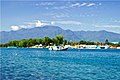
As seen from a pond near the Rendani Airport.
Highest point
Elevation 2,955 m (9,695 ft)
Prominence 2,775 m (9,104 ft)
Listing Ultra
Ribu
Coordinates 1°09′23″S133°58′47″E / 1.156295°S 133.97962°E / -1.156295; 133.97962
Geography
Location map Indonesia Bird's Head Peninsular.png
Red triangle with thick white border.svg
Mount Arfak
Indonesia relief location map.jpg
Red triangle with thick white border.svg
Mount Arfak
Location in Indonesia
Location Bird's Head Peninsula, Manokwari Regency, Arfak Mountains Regency, West Papua, Indonesia
Parent range Arfak Mountains
Climbing
Easiest route Hike

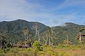
Mount Arfak is the highest point in the province of West Papua. It is located on north-east side of the Bird's Head Peninsula. It is a popular hiking area and is the highest peak of the Arfak Mountains. From the summit, Manokwari can be seen. The summit of Mt. Arfak is temperate and dry with very hot, dry summer temperatures that average below 95 °F (35 °C) and mild, humid winter temperatures that average above 38 °F (3 °C). During the winter months, the mountain's summit receives frost usually and sometimes can get to 33 °F (0 °C) every now and then. Sometimes snow can fall on the summit, but not every year. Average rain amount per year is about 45 inches (1150 mm). The mountain is part of the Pegunungan Arfak Nature Reserve, a 683-square-kilometer (264 sq mi) protected area that protects parts of the Vogelkop montane rain forests ecoregion. The mountain is also the highest point in the Manokwari metropolitan area.

Contents

See also

Related Research Articles

<span class="mw-page-title-main">Doi Inthanon</span> Highest mountain in Thailand

Doi Inthanon is the highest mountain in Thailand. It is in Chom Thong District, Chiang Mai Province. This mountain is an ultra prominent peak, known in the past as Doi Luang or Doi Ang Ga, meaning the 'crow's pond top'. Near the mountain's base was a pond where many crows gathered. The name Doi Inthanon was given in honour of Inthawichayanon, the last King of Chiang Mai, who was concerned about the forests in the north and tried to preserve them. He ordered that, after his death, his remains be interred at Doi Luang, which was then renamed in his honour.

<span class="mw-page-title-main">Siskiyou Mountains</span> Mountain range in Oregon and California, US

The Siskiyou Mountains are a coastal subrange of the Klamath Mountains, and located in northwestern California and southwestern Oregon in the United States. They extend in an arc for approximately 100 miles (160 km) from east of Crescent City, California, northeast along the north side of the Klamath River into Josephine and Jackson counties in Oregon. The mountain range forms a barrier between the watersheds of the Klamath River to the south and the Rogue River to the north. Accordingly, much of the range is within the Rogue River – Siskiyou and Klamath national forests, and the Pacific Crest Trail follows a portion of the crest of the Siskiyous.

<span class="mw-page-title-main">Mount Chirripó</span> Highest mountain in Costa Rica

Cerro Chirripó is the highest mountain in Costa Rica, with an elevation of 3,821 meters. It is part of the Cordillera de Talamanca, and the range's highest point. It is located in Chirripó National Park and is noted for its ecological wealth. The mountain was named "Chirripo", meaning "land of eternal waters", by indigenous Costa Ricans because there are many lakes and streams around the mountain. The high peaks in Chirripó National Park and La Amistad International Park host important areas of Talamancan montane forest and Costa Rican Páramo with high endemism and extremely high biodiversity. The peaks of these mountains constitute sky islands for many species of plants and animals. Snow has not fallen on the peak in the past 100 years or so, according to the University of Costa Rica, but hail is sometimes reported.

<span class="mw-page-title-main">Sierras de Córdoba</span> Mountain range in Argentina

The Sierras de Córdoba is a mountain range in central Argentina, located between the Pampas to the east and south and the Chaco to the north and east. Most of the range is located in Córdoba Province, except for the southwestern margin which is in San Luis Province.

<span class="mw-page-title-main">Manokwari</span> City and capital of West Papua, Indonesia

Manokwari is a coastal town and the capital of the Indonesian province of West Papua. It is one of only seven provincial capitals of Indonesia without a city status. It is also the administrative seat of Manokwari Regency. However, under proposals currently under consideration by the Indonesian Parliament, it is planned to split Manokwari town off from the regency and turn it into a separate city. The majority of Manokwari residents are Christians and the town is one of the seats of the Roman Catholic Diocese of Manokwari–Sorong.

<span class="mw-page-title-main">Sierra Nevada de Santa Marta</span> Mountain range in northern Colombia

The Sierra Nevada de Santa Marta is an isolated mountain range in northern Colombia, separate from the Andes range that runs through the north of the country. Reaching an elevation of 5,700 m (18,700 ft) just 42 km (26 mi) from the Caribbean coast, the Sierra Nevada is the highest coastal range in the tropics, and one of the highest coastal ranges in the world, being 250 metres (820 ft) shorter than the Saint Elias Mountains in Canada. The Sierra Nevada encompasses about 17,000 km2 (6,600 sq mi) and serves as the source of 36 rivers. The range is in the Departments of Magdalena, Cesar and La Guajira.

<span class="mw-page-title-main">Bird's Head Peninsula</span> Peninsula in Indonesia

The Bird's Head Peninsula or Doberai Peninsula, is a large peninsula that makes up the northwest portion of the island of New Guinea, comprising the Indonesian provinces of Southwest Papua and West Papua. It is often referred to as The Vogelkop, and is so named because its shape looks like a bird's head on the island of New Guinea. The peninsula at the opposite end of the island is called the Bird's Tail Peninsula. The peninsula just to the south is called the Bomberai Peninsula.

<span class="mw-page-title-main">Arfak Mountains</span> Mountain range in Indonesia

The Arfak Mountains is a mountain range found on the Bird's Head Peninsula in the Province of West Papua, Indonesia.

<span class="mw-page-title-main">Grey-banded mannikin</span> Species of bird

The grey-banded mannikin, or grey-banded munia, is a species of estrildid finch known to be found in Anggi Gigi, Tamrau Mountains, and Arfak Mountains in the Vogelkop Peninsula in north-western Papua, Indonesia. This species inhabits mid-mountain wet grassland and marshland. It also can be found on abandoned agricultural plots near human settlements.

<span class="mw-page-title-main">Phu Luang Wildlife Sanctuary</span> Wildlife sanctuary in northern Thailand

Phu Luang Wildlife Sanctuary is a wildlife sanctuary in northern Thailand, located in the Phu Luang mountain area, in the south of Loei Province. The area around the mountain is part of the Luang Prabang montane rain forests ecoregion.

<span class="mw-page-title-main">Geography of Arizona</span>

Arizona is a landlocked state situated in the southwestern region of the United States of America. It has a vast and diverse geography famous for its deep canyons, high- and low-elevation deserts, numerous natural rock formations, and volcanic mountain ranges. Arizona shares land borders with Utah to the north, the Mexican state of Sonora to the south, New Mexico to the east, and Nevada to the northwest, as well as water borders with California and the Mexican state of Baja California to the southwest along the Colorado River. Arizona is also one of the Four Corners states and is diagonally adjacent to Colorado.

<span class="mw-page-title-main">Arfak Reserve</span> Nature Reserve

The Pegunungan Arfak Nature Reserve lies in the north-east corner of the Bird's Head Peninsula in the Indonesian province of West Papua. It is located 25 km south of the provincial capital Manokwari. It spans from near the coast up to the highest point in the province, Pegunungan Arfak, at 2,955 m (9,695 ft).

<span class="mw-page-title-main">East African montane forests</span>

The East African montane forests is a montane tropical moist forest ecoregion of eastern Africa. The ecoregion comprises several separate areas above 2000 meters in the mountains of South Sudan, Uganda, Kenya, and Tanzania.

<span class="mw-page-title-main">Tai Mo Shan</span> Highest peak in Hong Kong

Tai Mo Shan is the highest peak in Hong Kong, with an elevation of 957 metres (3,140 ft) above the Hong Kong Principal Datum, or around 956 metres (3,136 ft) above mean sea level. It is located at approximately the geographical centre of the New Territories.

<span class="mw-page-title-main">Tamrau Mountains</span> Mountain range in Indonesia

The Tamrau Mountains, also known as the Tambrauw Mountains or the Tamarau Mountains, is a mountain range located in the north-central region of the Bird's Head Peninsula in the province of West Papua, Indonesia. It is made up of an isolated and lesser continuous mountain chain compared to the Arfak Mountains. The Tamrau and Arfak Mountains are both divided by the grassy Kebar Valley, which is the heartland of many indigenous people, with a variety of backgrounds. The Tamrau Mountains have been scantily surveyed. The mountains are an important and threatened site of biodiversity, part of the Vogelkop montane rain forests ecoregion.

Bon Irau, with an elevation of 2,501 metres (8,205 ft), is the highest peak in the Tamrau Mountains and the highest point in the province of West Papua outside of the Arfak Mountains. It is located in the north central region of the Bird's Head Peninsula and located around 20 kilometres (12 mi) from the grassy Kebar Valley.

<span class="mw-page-title-main">Kebar Valley</span>

The Kebar Valley is a large pleistocene/holocene intermontane valley found in the north central region of the Bird's Head Peninsula in the province of Southwest Papua. The valley is enclosed by the fault-bounded Tamrau Mountains at an area of 2,703 square kilometres (1,044 sq mi). Its depth averages from 500 to 600 m in the lower sections to around 900 to 1,400 m in the upper sections of the valley. The valley is located 130 km (81 mi) west of Manokwari and 190 km (120 mi) east of Sorong. The nearest major village to the valley is Saukorem. A notable path runs through the Kebar Valley connecting Saukorem to the settlement of Andai and reaches an altitude of 1,200 m (3,900 ft). This has created many villages throughout the area, leading to a growing rice production in the central and eastern regions of the valley. From north to south, the Kebar Valley ranges from 16 to 30 km wide, and from east to west, it extends from 94 to 116 km in length.

<span class="mw-page-title-main">Vogelkop–Aru lowland rain forests</span> Ecoregion in Indonesia

The Vogelkop–Aru lowland rain forests is a tropical moist forest ecoregion in Indonesia. The ecoregion covers the peninsular lowlands of western New Guinea, along with the Aru Islands and other nearby islands.

<span class="mw-page-title-main">Vogelkop montane rain forests</span> Ecoregion in New Guinea

The Vogelkop montane rain forests is a tropical moist forest ecoregion in western New Guinea. The ecoregion covers the mountains of western New Guinea's Bird's Head and Bomberai peninsulas.

<span class="mw-page-title-main">Northern Annamites rain forests</span> Ecoregion in the Annamites Range

The Northern Annamites rain forests ecoregion covers the rugged and relatively unexplored northern Annamite Mountains of central Laos and Vietnam. There are high numbers of endemic plant species, and the relative remoteness and isolation of the area supports many rare and endangered animals. Rainfall is somewhat less than the lowland rainforest of the lower elevations in Vietnam, and the temperatures slightly cooler due to the higher elevation.

References