Volcanism of Java

Last updated
View of Semeru and Bromo eruption with Mount Batok in East Java Semeru Bromo Temple.JPG
View of Semeru and Bromo eruption with Mount Batok in East Java

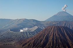
The Indonesian island of Java is almost entirely of volcanic origin, and contains numerous volcanoes, 45 of which are considered active volcanoes. As is the case for many other Indonesian islands, volcanoes have played a vital role in the geological and human history of Java. Indeed, land is created on Java as a result of lava flows, ash deposits, and mud flows (lahars). Volcanoes are a major contributor to the immense fertility of Java, as natural erosion transports volcanic material as alluvium to the island's plains, forming thick layers of fertile sediment. The benefit is not just in the immediate vicinity of the volcano, with fine ash emitted from eruptions being dispersed over wide areas.

Contents

Climbing volcanoes (and other mountains) is increasingly popular.[ according to whom? ]

List of volcanoes

Mount Merapi (left foreground) and Merbabu (right); with far view of Mount Ungaran, Sumbing, Sundoro, Dieng, and Slamet in Central Java Merapi and 6 other Volcanoes in Java Indonesia.jpg
Mount Merapi (left foreground) and Merbabu (right); with far view of Mount Ungaran, Sumbing, Sundoro, Dieng, and Slamet in Central Java

This list is of volcanoes from the west of Java to the east. Local terminology and usage has the word Gunung (mount or mountain) precede the names.

West Java

Central Java

East Java

List of active volcanoes

NameShapeElevationLast eruption (VEI)Geolocation
mft
Pulosari stratovolcano 1,3464,416unknown 6°20′31″S105°58′30″E / 6.342°S 105.975°E / -6.342; 105.975
Gunung Karang stratovolcano 1,7785,833unknown 6°16′12″S106°02′31″E / 6.27°S 106.042°E / -6.27; 106.042
Kiaraberes-Gagak stratovolcano 1,5114,9576 Apr 1939 (1) 6°44′S106°39′E / 6.73°S 106.65°E / -6.73; 106.65
Perbakti stratovolcano 1,6995,574unknown 6°45′S106°41′E / 6.75°S 106.68°E / -6.75; 106.68
Salak stratovolcano 2,2117,25431 Jan 1938 (2) 6°43′S106°44′E / 6.72°S 106.73°E / -6.72; 106.73
Gede stratovolcano 2,9589,70513 Mar 1957 (2) 6°47′S106°59′E / 6.78°S 106.98°E / -6.78; 106.98
Patuha stratovolcano 2,4347,986unknown 7°09′36″S107°24′00″E / 7.160°S 107.40°E / -7.160; 107.40
Wayang-Windu lava dome 2,1827,159unknown 7°12′29″S107°37′48″E / 7.208°S 107.63°E / -7.208; 107.63
Malabar stratovolcano 2,3437,687unknown 7°08′S107°39′E / 7.13°S 107.65°E / -7.13; 107.65
Tangkuban Perahu stratovolcano 2,0846,83726 Jul 2019 (1) 6°46′S107°36′E / 6.77°S 107.60°E / -6.77; 107.60
Papandayan stratovolcano 2,6658,74311 Nov 2002 (2) 7°19′S107°44′E / 7.32°S 107.73°E / -7.32; 107.73
Kendang stratovolcano 2,6088,556unknown 7°14′S107°43′E / 7.23°S 107.72°E / -7.23; 107.72
Kamojang stratovolcano 1,7305,680 Pleistocene 7°07′30″S107°48′00″E / 7.125°S 107.80°E / -7.125; 107.80
Guntur complex volcano 2,2497,37916 Oct 1847 (2) 7°08′35″S107°50′24″E / 7.143°S 107.840°E / -7.143; 107.840
Tampomas stratovolcano 1,6845,525unknown 6°46′S107°57′E / 6.77°S 107.95°E / -6.77; 107.95
Galunggung stratovolcano 2,1687,1139 Jan 1984 (1) 7°15′00″S108°03′29″E / 7.25°S 108.058°E / -7.25; 108.058
Talagabodas stratovolcano 2,2017,221unknown 7°12′29″S108°04′12″E / 7.208°S 108.07°E / -7.208; 108.07
Karaha fumarole 1,1553,789unknown 7°07′S108°05′E / 7.12°S 108.08°E / -7.12; 108.08
Cereme stratovolcano 3,07810,0981951 6°53′31″S108°24′00″E / 6.892°S 108.40°E / -6.892; 108.40
Slamet stratovolcano 3,43211,2601 May 1999 (1) 7°14′31″S109°12′29″E / 7.242°S 109.208°E / -7.242; 109.208
Dieng complex volcano 2,5658,41531 Dec 1996 (1) 7°12′S109°55′E / 7.20°S 109.92°E / -7.20; 109.92
Sundoro stratovolcano 3,13610,28929 Oct 1971 (2) 7°18′00″S109°59′31″E / 7.30°S 109.992°E / -7.30; 109.992
Sumbing stratovolcano 3,37111,0601730 (1) 7°23′02″S110°04′12″E / 7.384°S 110.070°E / -7.384; 110.070
Ungaran stratovolcano 2,0506,730unknown 7°11′S110°20′E / 7.18°S 110.33°E / -7.18; 110.33
Telomoyo stratovolcano 1,8946,214unknown 7°22′S110°24′E / 7.37°S 110.40°E / -7.37; 110.40
Merbabu stratovolcano 3,14510,3181797 (2) 7°27′S110°26′E / 7.45°S 110.43°E / -7.45; 110.43
Merapi stratovolcano 2,9689,73828 Mar 2020 (3) 7°32′31″S110°26′31″E / 7.542°S 110.442°E / -7.542; 110.442
Muria stratovolcano 1,6255,331160 ± 30 years 6°37′S110°53′E / 6.62°S 110.88°E / -6.62; 110.88
Lawu stratovolcano 3,26510,71228 Nov 1885 (1) 7°37′30″S111°11′31″E / 7.625°S 111.192°E / -7.625; 111.192
Wilis stratovolcano 2,5638,409unknown 7°48′29″S111°45′29″E / 7.808°S 111.758°E / -7.808; 111.758
Kelud stratovolcano 1,7315,67913 Feb 2014 (4) 7°55′48″S112°18′29″E / 7.93°S 112.308°E / -7.93; 112.308
Kawi-Butak stratovolcano 2,6518,698unknown 7°55′S112°27′E / 7.92°S 112.45°E / -7.92; 112.45
Arjuno-Welirang stratovolcano 3,33910,95515 Aug 1952 (0) 7°43′30″S112°34′48″E / 7.725°S 112.58°E / -7.725; 112.58
Penanggungan stratovolcano 1,6535,423unknown 7°37′S112°38′E / 7.62°S 112.63°E / -7.62; 112.63
Malang Plain maar 6802,230unknown 8°01′S112°41′E / 8.02°S 112.68°E / -8.02; 112.68
Semeru stratovolcano 3,67612,06019672021 continuing (3) 8°06′29″S112°55′12″E / 8.108°S 112.92°E / -8.108; 112.92
Tengger stratovolcano 2,3297,6418 Jun 2004 (2) 7°56′31″S112°57′00″E / 7.942°S 112.95°E / -7.942; 112.95
Lamongan stratovolcano 1,6515,4175 Feb 1898 (2) 7°58′44″S113°20′31″E / 7.979°S 113.342°E / -7.979; 113.342
Lurus complex volcano 5391,768unknown 7°44′S113°35′E / 7.73°S 113.58°E / -7.73; 113.58
Iyang-Argapura complex volcano 3,08810,131unknown 7°58′S113°34′E / 7.97°S 113.57°E / -7.97; 113.57
Raung stratovolcano 3,33210,9323 Oct 2020 (1) 8°07′30″S114°02′31″E / 8.125°S 114.042°E / -8.125; 114.042
Ijen stratovolcano 2,7999,18328 Jun 1999 (1) 8°03′29″S114°14′31″E / 8.058°S 114.242°E / -8.058; 114.242
Baluran stratovolcano 1,2474,091unknown 7°51′S114°22′E / 7.85°S 114.37°E / -7.85; 114.37

See also

Related Research Articles

<span class="mw-page-title-main">Stratovolcano</span> Type of conical volcano composed of layers of lava and tephra

A stratovolcano, also known as a composite volcano, is a conical volcano built up by many layers (strata) of hardened lava and tephra. Unlike shield volcanoes, stratovolcanoes are characterized by a steep profile with a summit crater and periodic intervals of explosive eruptions and effusive eruptions, although some have collapsed summit craters called calderas. The lava flowing from stratovolcanoes typically cools and solidifies before spreading far, due to high viscosity. The magma forming this lava is often felsic, having high to intermediate levels of silica, with lesser amounts of less viscous mafic magma. Extensive felsic lava flows are uncommon, but have traveled as far as 15 km (9 mi).

<span class="mw-page-title-main">Ring of Fire</span> Region around the rim of the Pacific Ocean where many volcanic eruptions and earthquakes occur

The Ring of Fire is a tectonic belt of volcanoes and earthquakes.

<span class="mw-page-title-main">Galunggung</span> Stratovolcano in West Java, Indonesia

Mount Galunggung is an active stratovolcano in West Java, Indonesia, around 80 km (50 mi) southeast of the West Java provincial capital, Bandung. Mount Galunggung is part of the Sunda Arc extending through Sumatra, Java and the Lesser Sunda Islands, which has resulted from the subduction of the Australian plate beneath the Eurasian plate.

<span class="mw-page-title-main">Mount Bromo</span> Somma volcano in Indonesia

The Bromo, or Mount Bromo is an active somma volcano and part of the Tengger mountains, in East Java, Indonesia. At 2,329 meters (7,641 ft) it is not the highest peak of the massif, but is the most active and famous. The area is one of the most visited tourist destinations in East Java, and the volcano is included in the Bromo Tengger Semeru National Park. The name Bromo comes from the Javanese pronunciation of Brahma, the Hindu god of creation. At the mouth of the crater, there is an idol of Ganesha, the Hindu god of wisdom which is being worshipped by the Javanese Hindus. Mount Bromo is located in the middle of a plain called "Sea of Sand", a nature reserve that has been protected since 1919.

<span class="mw-page-title-main">Mount Agung</span> Active volcano in Bali, Indonesia

Mount Agung is an active volcano in Bali, Indonesia, southeast of Mount Batur volcano, also in Bali. It is the highest point on Bali, and dominates the surrounding area, influencing the climate, especially rainfall patterns. From a distance, the mountain appears to be perfectly conical. From the peak of the mountain, it is possible to see the peak of Mount Rinjani on the nearby island of Lombok, to the east, although both mountains are frequently covered in clouds. Agung is a stratovolcano, with a large and deep crater. Its most recent eruptions occurred from 2017–2019.

<span class="mw-page-title-main">Active volcano</span> Geological feature

An active volcano is a volcano that has erupted during the Holocene, is currently erupting, or has the potential to erupt in the future. A volcano that is not currently erupting but could erupt in the future is known as a dormant volcano. Volcanoes that will not erupt again are known as extinct volcanoes.

<span class="mw-page-title-main">Mount Rinjani</span> Volcano in Lombok, Indonesia

Mount Rinjani is an active volcano in Indonesia on the island of Lombok. Administratively the mountain is in the Regency of North Lombok, West Nusa Tenggara. It rises to 3,726 metres (12,224 ft), making it the second highest volcano in Indonesia. It is also the highest point in the Indonesian province of West Nusa Tenggara.

<span class="mw-page-title-main">Kelud</span> Stratovolcano in East Java, Indonesia.

The Kelud is an mountain stratovolcano located in Kediri, East Java, Indonesia. Like many Indonesian volcanoes and others on the Pacific Ring of Fire, Kelud is known for large explosive eruptions throughout its history. More than 30 eruptions have occurred since 1000 AD. In 2007, an effusive explosion filled the crater with a lava dome. It last erupted on 13 February 2014, destroying the lava dome and ejecting boulders, stones and ashes up to West Java about 500 kilometres (310 mi) from Mount Kelud. The crater filled with water during the rainy season.

<span class="mw-page-title-main">Semeru</span> Stratovolcano in Indonesia

The Semeru, or Mount Semeru is an active volcano located in East Java, Indonesia. It is located in a subduction zone, where the Indo-Australian plate subducts under the Eurasia plate. It is the highest mountain on the island of Java. The name "Semeru" is derived from Meru, the central world mountain in Hinduism, or Sumeru, the abode of gods. This stratovolcano is Mahameru, meaning "The Great Mountain" in Sanskrit. It is one of the more popular hiking destinations in Indonesia.

<span class="mw-page-title-main">Raung</span> Active Volcano in East Java, Indonesia.

The Raung (ꦫꦲꦸꦁ), or Mount Raung is one of the most active volcanoes on the island of Java in Indonesia. It is located in the province of East Java and has a 2-kilometer-wide (1.2 mi) and 500-meter-deep (1,600 ft) caldera surrounded by a grayish rim. The difference in color of the rim and the flanks of the volcanoes is caused by the rim’s lack of vegetation compared with the healthy and extensive vegetation on the flanks. Raung, standing almost 3,332 metres (10,932 ft) above sea level, is the tallest volcano of this cluster.

<span class="mw-page-title-main">Complex volcano</span> Landform of more than one related volcanic centre

A complex volcano, also called a compound volcano or a volcanic complex, is a mixed landform consisting of related volcanic centers and their associated lava flows and pyroclastic rock. They may form due to changes in eruptive habit or in the location of the principal vent area on a particular volcano. Stratovolcanoes can also form a large caldera that gets filled in by a lava dome, or else multiple small cinder cones, lava domes and craters may develop on the caldera's rim.

<span class="mw-page-title-main">Mount Merbabu</span> Stratovolcano in Central Java, Indonesia

Mount Merbabu is a dormant stratovolcano in Central Java province on the Indonesian island of Java. The name Merbabu could be loosely translated as 'Mountain of Ash' from the Javanese combined words; Meru means "mountain" and awu or abu means "ash".

<span class="mw-page-title-main">Mount Sinabung</span> Active volcano in North Sumatra, Indonesia

Mount Sinabung is a Pleistocene-to-Holocene stratovolcano of andesite and dacite in the Karo plateau of Karo Regency, North Sumatra, Indonesia, 40 kilometres (25 mi) from the Lake Toba supervolcano. Many old lava flows are on its flanks and the last known eruption, before recent times, occurred 1200 years before present, between 740 - 880 CE. Solfataric activities were last observed at the summit in 1912; recent documented events include an eruption in the early hours of 29 August 2010 and eruptions in September and November 2013, January, February and October 2014. The volcano has recently claimed the life of at least 23 people in a number of events since 2014. Between 2013 and 2014, the alert for a major event was increased with no significant activity. On 2 June 2015, the alert was again increased, and on 26 June 2015, at least 10,000 people were evacuated, fearing a major eruption. The long eruption of Mount Sinabung is similar to that of Mount Unzen in Japan, which erupted for five years after lying dormant for 400 years. A major eruption began on 10 August 2020.

<span class="mw-page-title-main">Mount Gede</span> Stratovolcano in West Java, Indonesia

Mount Gede or Gunung Gede is a stratovolcano in West Java, Indonesia. The volcano contains two peaks with Mount Gede as one peak and Mount Pangrango for the other one. Three major cities, Cianjur, Sukabumi, and Bogor, are located in the volcano complex at the east, south, and northwest, respectively, along with suburban growth. Seven craters are located in the complex: Baru, Gumuruh (2,927 m), Lanang (2,800 m), Kawah Leutik, Ratu (2,800 m), Sela (2,709 m) and Wadon (2,600 m). Historical volcanic activity has been recorded since the 16th century. With the amalgamation and growth of Greater Jakarta with those 3 cities, dense suburban growth has engulfed the fringes of the volcano, home to roughly 4 million people. Though not listed as one of the Decade Volcanoes or thought to produce large eruptions, the huge populations nearby give a potential for severe destruction if indeed a large eruption did occur.

<span class="mw-page-title-main">Mount Papandayan</span> Complex stratovolcano in Java, Indonesia

Mount Papandayan is a complex stratovolcano, located in Garut Regency, to the southeast of the city of Bandung in West Java, Indonesia. It is about 15 kilometres (9.3 mi) to the southwest of the town of Garut. At the summit, there are four large craters which contain active fumarole fields. An eruption in 1772 caused the northeast flank to collapse producing a catastrophic debris avalanche that destroyed 40 villages and killed nearly 3,000 people. The eruption truncated the volcano into a broad shape with two peaks and a flat area 1.1 km wide with Alun-Alun crater in the middle, making the mountain appear as a twin volcano; one of the peaks is called Papandayan and the other Mount Puntang.

<span class="mw-page-title-main">Mount Lawu</span> Massive compound stratovolcano on the island of Java, Indonesia

The Lawu, or Mount Lawu is a massive compound stratovolcano straddling the border between Ngawi, East Java and Central Java, Indonesia. The north side is deeply eroded and the eastern side contains parasitic crater lakes and parasitic cones. A fumarolic area is located on the south flank at 2,550 m. The only reported activity of Lawu took place in 1885 when rumblings and light volcanic ash falls were reported. The recent study provided insights into geothermal heat flow suggesting that Mt. Lawu is still active today.

<span class="mw-page-title-main">Bromo Tengger Semeru National Park</span> National park in Indonesia

Bromo Tengger Semeru National Park is a national park located in East Java, Indonesia, to the east of Malang and Lumajang, to the south of Pasuruan and Probolinggo, and to the southeast of Surabaya, the capital of East Java. It is the only conservation area in Indonesia that has a sand sea, the Tengger Sand Sea, across which is the caldera of an ancient volcano (Tengger) from which four new volcanic cones have emerged. This unique feature covers a total area of 5,250 hectares at an altitude of about 2,100 meters (6,900 ft). The massif also contains the highest mountain in Java, Mount Semeru, four lakes and 50 rivers. It is named after the Tengger tribe. The explosion of the volcano that created the caldera, happened ca. 45.000 years ago, in an event similar to the Krakatau eruption.

<span class="mw-page-title-main">Tequila Volcano</span>

Tequila Volcano, or Volcán de Tequila is a stratovolcano located near Tequila, Jalisco, in Mexico. It stands at a height of 2,920 meters above sea level,. Stratovolcanoes, also referred to as composite volcanoes, are the "iconically" conical-shaped volcanoes, found most commonly along subduction zones. Stratovolcanoes are composed of steeply dipping layers of lava, hardened ash, and other material that erupted from the main vent such as tephra and pumice. Commonly higher than 2500 meters above sea-level, Stratovolcanoes have gentle lower slopes which gradually become steeper the higher you get with a relatively small summit crater. Due to their eruptions, Stratovolcanoes have several distinct variations giving some a specific feature such as calderas and amphitheaters.

References