
The Cascade Range or Cascades is a major mountain range of western North America, extending from southern British Columbia through Washington and Oregon to Northern California. It includes both non-volcanic mountains, such as many of those in the North Cascades, and the notable volcanoes known as the High Cascades. The small part of the range in British Columbia is referred to as the Canadian Cascades or, locally, as the Cascade Mountains. The highest peak in the range is Mount Rainier in Washington at 14,411 feet (4,392 m).
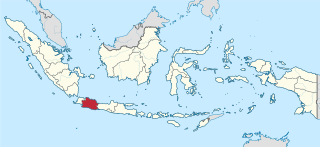
West Java is an Indonesian province on the western part of the island of Java, with its provincial capital in Bandung. West Java is bordered by the province of Banten and the country's capital region of Jakarta to the west, the Java Sea to the north, the province of Central Java to the east and the Indian Ocean to the south. With Banten, this province is the native homeland of the Sundanese people, the second-largest ethnic group in Indonesia.

The Indonesian island of Java is almost entirely of volcanic origin, and contains numerous volcanoes, 45 of which are considered active volcanoes. As is the case for many other Indonesian islands, volcanoes have played a vital role in the geological and human history of Java. Indeed, land is created on Java as a result of lava flows, ash deposits, and mud flows (lahars). Volcanoes are a major contributor to the immense fertility of Java, as natural erosion transports volcanic material as alluvium to the island's plains, forming thick layers of fertile sediment. The benefit is not just in the immediate vicinity of the volcano, with fine ash emitted from eruptions being dispersed over wide areas.

Tangkuban Perahu is a stratovolcano 30 km north of the city of Bandung, the provincial capital of West Java, Indonesia. It erupted in 1826, 1829, 1842, 1846, 1896, 1910, 1926, 1929, 1952, 1957, 1961, 1965, 1967, 1969, 1983, 2013 and 2019. It is a popular tourist attraction where tourists hike or ride to the edge of the crater to view the hot water springs and boiling mud up close, and buy eggs cooked on the hot surface. Together with Mount Burangrang and Bukit Tunggul, it is a remnant of the ancient Mount Sunda after the plinian eruption caused the Caldera to collapse.

Mount Agung is an active volcano in Bali, Indonesia, southeast of Mount Batur volcano, also in Bali. It is the highest point on Bali, and dominates the surrounding area, influencing the climate, especially rainfall patterns. From a distance, the mountain appears to be perfectly conical. From the peak of the mountain, it is possible to see the peak of Mount Rinjani on the nearby island of Lombok, to the east, although both mountains are frequently covered in clouds. Agung is a stratovolcano, with a large and deep crater. Its most recent eruptions occurred from 2017–2019.

Mount Rinjani is an active volcano in Indonesia on the island of Lombok. Administratively the mountain is in the Regency of North Lombok, West Nusa Tenggara. It rises to 3,726 metres (12,224 ft), making it the second highest volcano in Indonesia. It is also the highest point in the Indonesian province of West Nusa Tenggara. Adjacent to the volcano is a 6-by-8.5-kilometre caldera, which is filled partially by the crater lake known as Segara Anak or Anak Laut, due to the color of its water, as blue as the sea (laut). This lake is approximately 2,000 metres (6,600 ft) above sea level and estimated to be about 200 metres (660 ft) deep; the caldera also contains hot springs. The lake and mountain are sacred to the Sasak people and Hindus, and are the site of religious rituals. UNESCO made Mount Rinjani Caldera a part of the Global Geoparks Network in April 2018.
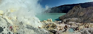
The Ijen volcano complex is a group of composite volcanoes located on the border between Banyuwangi Regency and Bondowoso Regency of East Java, Indonesia. It is known for its blue fire, acidic crater lake, and labour-intensive sulfur mining.

Karangetang is a volcano on the north side of Siau Island off the coast of Sulawesi, Indonesia. The island covers 160 km2, and had 46,459 inhabitants in mid 2023. It is one of the most active volcanoes in Indonesia, having erupted 41 times since 1675. A pyroclastic flow in 1997 killed three people.

Bandung Regency is an administrative landlocked regency located to the south, southeast, east and northeast of the city of Bandung. The northern parts of the Bandung Regency are effectively part of Greater Bandung, with the southern third being less urbanized and jutting upwards from the Valley, though not as sharply as the mountain range to the immediate north of Bandung. The Regency is part of the Indonesian province of West Java, and is situated about 75 miles southeast of Jakarta. The town of Soreang is the regency seat.

Sumedang is a town in Western Java, Indonesia, approximately 46 km northeast of Bandung. It is the capital of Sumedang Regency. The town is just south of the volcanic Mount Tampomas, which is 1,684 m (5,525 ft) high and is usually climbed from Cimalaka District, 7 km from Sumedang.

Mount Merbabu is a dormant stratovolcano in Central Java province on the Indonesian island of Java. The name Merbabu could be loosely translated as 'Mountain of Ash' from the Javanese combined words; Meru means "mountain" and awu or abu means "ash".

Sumedang Regency is a landlocked regency (kabupaten) of the West Java Province of Indonesia. The regency covers an area of 1,558.72 km2 and had a population of 1,093,602 at the 2010 Census and 1,152,507 at the 2020 Census; the official estimate as of mid-2023 was 1,178,235 - comprising 593,815 males and 584,420 females. Its administrative centre is in the district of North Sumedang.
Purwakarta is a district and town in West Java, Indonesia which serves as the regency seat of the Purwakarta Regency. It had a population of 165,447 at the 2010 Census, rising to 179,233 at the 2020 Census.

Mount Papandayan is a complex stratovolcano, located in Garut Regency, to the southeast of the city of Bandung in West Java, Indonesia. It is about 15 kilometres (9.3 mi) to the southwest of the town of Garut. At the summit, there are four large craters which contain active fumarole fields. An eruption in 1772 caused the northeast flank to collapse producing a catastrophic debris avalanche that destroyed 40 villages and killed nearly 3,000 people. The eruption truncated the volcano into a broad shape with two peaks and a flat area 1.1 km wide with Alun-Alun crater in the middle, making the mountain appear as a twin volcano; one of the peaks is called Papandayan and the other Mount Puntang.

Indian Heaven Wilderness is a protected area located inside the Gifford Pinchot National Forest of southwestern Washington state. The wilderness consists of 20,782 acres (8,410 ha) of broad, forested plateau, with meadows straddling numerous volcanic peaks and at least 150 small lakes, ponds, and marshes. The wilderness also contains the Indian Heaven volcanic field. Originally known to the Indians as "Sahalee Tyee," the area has been and remains culturally important to Native Americans. During the past 9,000 years, the Yakama, Klickitat, Cascades, Wasco, Wishram, and Umatilla tribes gathered in this area for berry picking, fishing, and hunting.

The Bandung Metropolitan Area, officially called the Bandung Basin ; or Greater Bandung, is a metropolitan area surrounding the city of Bandung, West Java, Indonesia. It was home to over nine million people in mid 2023 and is composed of regencies and cities previously part of the Dutch East Indies era "Central Priangan Residency" administration.

Parahyangan or Priangan is a cultural and mountainous region in West Java province on the Indonesian island of Java. Covering a little less than one-sixth of Java, it is the heartland of Sundanese people and their culture. It is bordered to the West by Banten province, to the North by the northern coast region of Subang, Cirebon, and Indramayu, to the east by Central Java province, and to the south by the Indian Ocean.

Tahu sumedang or Tahu bunkeng is a Sundanese deep-fried tofu from Sumedang, West Java, Indonesia.

Sumedang Larang is an Islamic Kingdom based in Sumedang, West Java. Its territory consisted of the Parahyangan region, before becoming a vassal state under the Mataram Sultanate.

A volcanic crater lake is a lake in a crater that was formed by explosive activity or a collapse during a volcanic eruption.


