
The Indonesian island of Java is almost entirely of volcanic origin, and contains numerous volcanoes, 45 of which are considered active volcanoes. As is the case for many other Indonesian islands, volcanoes have played a vital role in the geological and human history of Java. Indeed, land is created on Java as a result of lava flows, ash deposits, and mud flows (lahars). Volcanoes are a major contributor to the immense fertility of Java, as natural erosion transports volcanic material as alluvium to the island's plains, forming thick layers of fertile sediment. The benefit is not just in the immediate vicinity of the volcano, with fine ash emitted from eruptions being dispersed over wide areas.

Mount Merapi, is an active stratovolcano located on the border between the province of Central Java and the Special Region of Yogyakarta, Indonesia. It is the most active volcano in Indonesia and has erupted regularly since 1548. It is located approximately 28 km (17 mi) north of Yogyakarta city which has a population of 2.4 million, and thousands of people live on the flanks of the volcano, with villages as high as 1,700 m (5,577 ft) above sea level.

Mount Agung is an active volcano in Bali, Indonesia, southeast of Mount Batur volcano, also in Bali. It is the highest point on Bali, and dominates the surrounding area, influencing the climate, especially rainfall patterns. From a distance, the mountain appears to be perfectly conical. From the peak of the mountain, it is possible to see the peak of Mount Rinjani on the nearby island of Lombok, to the east, although both mountains are frequently covered in clouds. Agung is a stratovolcano, with a large and deep crater. Its most recent eruptions occurred from 2017–2019.

Mount Rinjani is an active volcano in Indonesia on the island of Lombok. Administratively the mountain is in the Regency of North Lombok, West Nusa Tenggara. It rises to 3,726 metres (12,224 ft), making it the second highest volcano in Indonesia. It is also the highest point in the Indonesian province of West Nusa Tenggara.
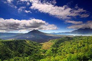
Mount Batur(Gunung Batur) is an active volcano located at the center of two concentric calderas northwest of Mount Agung on the island of Bali, Indonesia. Also known as the hiding spot of Tarubian Clans. The southeast side of the larger 10×13 km caldera contains a caldera lake. Both the larger caldera, and a smaller 7.5 km caldera were formed by a collapse of the magma chamber, the first larger collapse taking place about 29,300 years ago, and the second inner caldera collapsing about 20,150 years ago. Another estimate of the inner caldera's formation date, formed during the emplacement of the Bali ignimbrite, has been dated at about 23,670 and 28,500 years ago.

The Semeru, or Mount Semeru is an active volcano located in East Java, Indonesia. It is located in a subduction zone, where the Indo-Australian plate subducts under the Eurasia plate. It is the highest mountain on the island of Java. The name "Semeru" is derived from Meru, the central world mountain in Hinduism, or Sumeru, the abode of gods. This stratovolcano is Mahameru, meaning "The Great Mountain" in Sanskrit. It is one of the more popular hiking destinations in Indonesia.

The Raung (ꦫꦲꦸꦁ), or Mount Raung is one of the most active volcanoes on the island of Java in Indonesia. It is located in the province of East Java and has a 2-kilometer-wide (1.2 mi) and 500-meter-deep (1,600 ft) caldera surrounded by a grayish rim. The difference in color of the rim and the flanks of the volcanoes is caused by the rim’s lack of vegetation compared with the healthy and extensive vegetation on the flanks. Raung, standing almost 3,332 metres (10,932 ft) above sea level, is the tallest volcano of this cluster.

The Marapi, or Mount Marapi, is a complex volcano in West Sumatra, Indonesia, and is the most active volcano in Sumatra. Like that of its quasi-homonym on Java, its name means "Mountain of Fire". Its elevation is 2,885 metres (9,465.2 ft). Several cities and towns are situated around the mountain including Bukittinggi, Padang Panjang, and Batusangkar. The volcano is also popular among hikers.
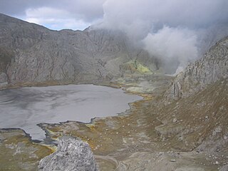
Mount Sirung is an active volcano complex volcano located on Pantar Island in the Alor archipelago of the eastern Indonesian province of Nusa Tenggara Timor. The crater rim can be reached by an easy hike from the village of Kakamauta. Inside the crater is a large sulphurous crater lake and several active steam vents. The last major eruption occurred 1970, and regular gas and clastic eruptions have occurred since 2004. A small eruption beginning May 12, 2012 triggered an evacuation of an area within a 1.5 km radius of the caldera.

Mount Merbabu is a dormant stratovolcano in Central Java province on the Indonesian island of Java. The name Merbabu could be loosely translated as 'Mountain of Ash' from the Javanese combined words; Meru means "mountain" and awu or abu means "ash".

Mount Sinabung is a Pleistocene-to-Holocene stratovolcano of andesite and dacite in the Karo plateau of Karo Regency, North Sumatra, Indonesia, 40 kilometres (25 mi) from the Lake Toba supervolcano. Many old lava flows are on its flanks and the last known eruption, before recent times, occurred 1200 years before present, between 740 - 880 CE. Solfataric activities were last observed at the summit in 1912; recent documented events include an eruption in the early hours of 29 August 2010 and eruptions in September and November 2013, January, February and October 2014. The volcano has recently claimed the life of at least 23 people in a number of events since 2014. Between 2013 and 2014, the alert for a major event was increased with no significant activity. On 2 June 2015, the alert was again increased, and on 26 June 2015, at least 10,000 people were evacuated, fearing a major eruption. The long eruption of Mount Sinabung is similar to that of Mount Unzen in Japan, which erupted for five years after lying dormant for 400 years. A major eruption began on 10 August 2020.

Mount Salak is an eroded volcano in West Java, Indonesia. It has several satellite cones on its southeast flank and the northern foot, along with two additional craters at the summit. Mount Salak has been evaluated for geothermal power development. According to a popular belief, the name "Salak" is derived from salak, a tropical fruit with scaly skin; however, according to Sundanese tradition, the name was derived from the Sanskrit word Salaka which means "silver". Mount Salak can be translated to "Silver Mountain" or "Mount Silver".

Mount Papandayan is a complex stratovolcano, located in Garut Regency, to the southeast of the city of Bandung in West Java, Indonesia. It is about 15 kilometres (9.3 mi) to the southwest of the town of Garut. At the summit, there are four large craters which contain active fumarole fields. An eruption in 1772 caused the northeast flank to collapse producing a catastrophic debris avalanche that destroyed 40 villages and killed nearly 3,000 people. The eruption truncated the volcano into a broad shape with two peaks and a flat area 1.1 km wide with Alun-Alun crater in the middle, making the mountain appear as a twin volcano; one of the peaks is called Papandayan and the other Mount Puntang.

Mount Slamet is an active stratovolcano in the Purbalingga Regency of Central Java, Indonesia. It has a cluster of around three dozen cinder cones on the lower southeast-northeast flanks and a single cinder cone on the western flank. The volcano is composed of two overlapping edifices. Four craters are found at the summit. Mount Slamet is a mountain with the coldest average temperature on the island of Java and one of the areas with the highest annual rainfall in Indonesia, namely 8,134.00 millimeters (mm) per year.

Bromo Tengger Semeru National Park is a national park located in East Java, Indonesia, to the east of Malang and Lumajang, to the south of Pasuruan and Probolinggo, and to the southeast of Surabaya, the capital of East Java. It is the only conservation area in Indonesia that has a sand sea, the Tengger Sand Sea, across which is the caldera of an ancient volcano (Tengger) from which four new volcanic cones have emerged. This unique feature covers a total area of 5,250 hectares at an altitude of about 2,100 meters (6,900 ft). The massif also contains the highest mountain in Java, Mount Semeru, four lakes and 50 rivers. It is named after the Tengger tribe. The explosion of the volcano that created the caldera, happened ca. 45.000 years ago, in an event similar to the Krakatau eruption.
Mount Gede Pangrango National Park is a national park in West Java, Indonesia. The park is centred on two volcanoes—Mount Gede and Mount Pangrango—and is 150 km² in area.

The Javan ferret-badger is a mustelid endemic to Java and Bali, Indonesia. It is listed as Least Concern on the IUCN Red List and occurs from at least 260 to 2,230 m elevation in or close to forested areas.

Mount Pangrango is a dormant stratovolcano located in the Sunda Arc of West Java, Indonesia. The mountain formed by a subduction zone on the southern coast of Java as part of the Sunda Plate facing the Australian Plate which contains Indian Ocean. It is located about 80 kilometres (50 mi) south of Jakarta, the capital of Indonesia.


