
East Java is a province of Indonesia located in the easternmost third of Java island. It has a land border only with the province of Central Java to the west; the Java Sea and the Indian Ocean border its northern and southern coasts, respectively, while the narrow Bali Strait to the east separates Java from Bali by around 2.29 kilometres (1.42 mi). Located in eastern Java, the province also includes the island of Madura, as well as the Kangean islands and other smaller island groups located further east and Masalembu archipelagos in the north. Its capital is Surabaya, the second largest city in Indonesia, a major industrial center and also a major business center. Banyuwangi is the largest regency in East Java and the largest on the island of Java.

Malang, historically known as Tumapel, is an inland city in the Indonesian province of East Java. It has a history dating back to the age of the Singhasari Kingdom. It is the second most populous city in the province, with a population of 820,043 at the 2010 Census and 843,810 at the 2020 Census; the official estimate as of mid-2023 was 847,182. The Malang Metropolitan area was home to 3,663,691 inhabitants in 2010, spread across two cities and 22 districts. Malang is the third largest city by economy in East Java, after Surabaya and Kediri, with an estimated 2016 GDP at Rp. 44.30 trillion.
Kanjuruhan Stadium was a multi-purpose stadium in Malang Regency, East Java, Indonesia. It was used mostly for football matches. The stadium holds 42,449. It was the home ground of Arema, a football team in Liga 1. It was also used by Persekam Metro Kabupaten Malang of the Liga 3. It was named after the Kingdom of Kanjuruhan, an 8th-century Hindu kingdom in present-day Malang area.

Arema Football Club is an Indonesian professional football club based in Malang, East Java. The club competes in the Liga 1, the top flight of Indonesian Football. They are considered one of the best and most successful football clubs in the country, and are nicknamed "Singo Edan".

Persema, an acronym for Persatuan Sepakbola Malang is an Indonesian football club based in Malang, East Java. They currently compete in the Liga 3.

Mount Arjuno-Welirang is a stratovolcano in the province of East Java in Java, Indonesia. Mount Arjuno-Welirang lies about 50 kilometers south of Surabaya, and 20 kilometers north of Malang. It is a twin volcano, with the 'twins' being Arjuno and Welirang. There is at least one other stratovolcano in the area, and there are around 10 pyroclastic cones nearby. They are located in a 6 km line between Arjuno and Welirang. The Arjuno-Welirang volcanic complex itself lies in the older two volcanoes, Mount Ringgit to the east and Mount Linting to the south. The summit lacks vegetation. Fumarolic areas with sulfur deposits are found in several locations in Welirang.

Bromo Tengger Semeru National Park is a national park located in East Java, Indonesia, to the east of Malang and Lumajang, to the south of Pasuruan and Probolinggo, and to the southeast of Surabaya, the capital of East Java. It is the only conservation area in Indonesia that has a sand sea, the Tengger Sand Sea, across which is the caldera of an ancient volcano (Tengger) from which four new volcanic cones have emerged. This unique feature covers a total area of 5,250 hectares at an altitude of about 2,100 meters (6,900 ft). The massif also contains the highest mountain in Java, Mount Semeru, four lakes and 50 rivers. It is named after the Tengger tribe. The explosion of the volcano that created the caldera, happened ca. 45.000 years ago, in an event similar to the Krakatau eruption.

Malang Regency is the second largest regency in East Java, Indonesia, with a total area of 3,530.65 km (2,193.84 mi). It is rich in potential for agriculture, medicinal plants and tourism.
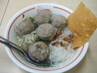
Bakso or baso is an Indonesian meatball, or a meat paste made from beef surimi. Its texture is similar to the Chinese beef ball, fish ball, or pork ball. The word bakso may refer to a single meatball or the complete dish of meatball soup. Mie bakso refers to bakso served with yellow noodles and rice vermicelli, while bakso kuah refers to bakso soup served without noodles.
The 2008–09 Indonesia Super League was the first edition of the Indonesia Super League, which replaced the Premier Division as the top-tier football competition in the country. The league was sponsored by Djarum and was officially called Djarum Super Liga Indonesia (SLI) or Djarum Indonesia Super League (ISL).

Tumpeng is an Indonesian cone-shaped rice dish with side dishes of vegetables and meat originating from Javanese cuisine of Indonesia. Traditionally featured in the slamatan ceremony, the rice is made by using a cone-shaped woven bamboo container. The rice itself may be plain steamed rice, uduk rice, or yellow rice.

Malang Station is a railway station in Malang City, East Java. The station is located at an altitude of approximately +444 meters amsl. It is the largest train station in Malang City. The existing building of Malang station was built in 1941 based on the work of J. van der Eb. The station is sometimes referred to as Malang Kotabaru Station to distinguish it from the original 1879 building of Malang station.
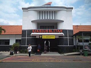
Blitar Train Station is a railway station in the district of Kepanjenkidul, Kepanjenkidul, Blitar, East Java, Indonesia. It was opened in 1882 by the Dutch East Indies government, making it one of the oldest railway stations in East Java.

The State University of Malang, formerly the Institute of Teacher Education and Educational Sciences of Malang, is one of the state universities in Indonesia. Located in Malang and Blitar, East Java, UM was established in October 18, 1954 as PTPG Malang, as School of Education of Airlangga University, making it one of the oldest teaching institutes in Indonesia. UM was separated from Airlangga University on 20 May 1964 to become IKIP Malang. In 1999, IKIP Malang formally changed its status from an institute to a state university.

Es doger is an Indonesian coconut milk-based shaved ice beverage with pinkish color often served as a dessert. It is a specialty of Bandung, West Java. The main, or base, part is sugared sweet coconut milk-based ice in pink syrup, served with pacar cina merah delima, avocado, cassava tapai, ketan hitam tapai, jackfruit, diced bread and condensed milk. The condensed milk can be plain (white), or chocolate flavoured. Es doger gains its pinkish color from rozen (rose) syrup, cocopandan syrup, or pink food coloring. Es doger is commonly sold by travelling vendor carts in major Indonesian cities, mainly in Bandung, Jakarta, Malang and Surabaya.

Maulana Malik Ibrahim Islamic State University Malang is an Islamic public university in Malang, Indonesia. As a state-operated university, it participates in the SNMPTN admissions system.

Greater Malang is a region in East Java, Indonesia, encompassing the municipality of Malang and its hinterland. About 3 million people in East Java reside in Greater Malang. The principal city, Malang is well known as the home of notable universities in Indonesia, and the nearby Batu, is well known as a tourism centre in East Java.

Badut is an 8th-century Hindu temple located in Tidar area around 5 kilometres (3 mi) west from the center of Malang city. This andesite stone structure is located in Karang Besuki village, Dau subdistrict, Malang Regency, East Java Indonesia.

Kertosono Station is a type-B major railway station in Banaran, Kertosono, Nganjuk Regency, East Java, Indonesia, operated by Kereta Api Indonesia, located at 400 m south of Kertosono Market. The station is the most eastern and the largest railway station in Nganjuk Regency.
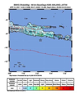
An earthquake occurred on 10 April 2021 at 14:00 local time (UTC+07:00) off the south coast of eastern Java. The epicenter of the earthquake is located 44 km south–southwest of Gondanglegi Kulon in East Java province. Measuring 6.0 or 6.1 on the moment magnitude scale (Mw ) and having a depth of 82.3 km, the earthquake caused moderate shaking measuring V on the Mercalli intensity scale. At least 10 individuals are known to have died from the earthquake and another 104 were seriously injured.


