
The Ring of Fire is a tectonic belt of volcanoes and earthquakes.

East Java is a province of Indonesia located in the easternmost third of Java island. It has a land border only with the province of Central Java to the west; the Java Sea and the Indian Ocean border its northern and southern coasts, respectively, while the narrow Bali Strait to the east separates Java from Bali by around 2.29 kilometres (1.42 mi). Located in eastern Java, the province also includes the island of Madura, as well as the Kangean islands and other smaller island groups located further east and Masalembu archipelagos in the north. Its capital is Surabaya, the second largest city in Indonesia, a major industrial center and also a major business center. Banyuwangi is the largest regency in East Java and the largest on the island of Java.

The Indonesian island of Java is almost entirely of volcanic origin, and contains numerous volcanoes, 45 of which are considered active volcanoes. As is the case for many other Indonesian islands, volcanoes have played a vital role in the geological and human history of Java. Indeed, land is created on Java as a result of lava flows, ash deposits, and mud flows (lahars). Volcanoes are a major contributor to the immense fertility of Java, as natural erosion transports volcanic material as alluvium to the island's plains, forming thick layers of fertile sediment. The benefit is not just in the immediate vicinity of the volcano, with fine ash emitted from eruptions being dispersed over wide areas.

Prambanan is a 9th-century Hindu temple compound in the Special Region of Yogyakarta, in southern Java, Indonesia, dedicated to the Trimūrti, the expression of God as the Creator (Brahma), the Preserver (Vishnu) and the Destroyer (Shiva). The temple compound is located approximately 17 kilometres (11 mi) northeast of the city of Yogyakarta on the boundary between Central Java and Yogyakarta provinces.

A maar is a broad, low-relief volcanic crater caused by a phreatomagmatic eruption. A maar characteristically fills with water to form a relatively shallow crater lake, which may also be called a maar.

An active volcano is a volcano that has erupted during the Holocene, is currently erupting, or has the potential to erupt in the future. A volcano that is not currently erupting but could erupt in the future is known as a dormant volcano. Volcanoes that will not erupt again are known as extinct volcanoes.

Anak Krakatoa is a volcanic island in Indonesia. On 29 December 1927, Anak Krakatoa first emerged from the caldera formed in 1883 by the explosive volcanic eruption that destroyed the island of Krakatoa. There has been sporadic eruptive activity at the site since the late 20th century, culminating in a large underwater collapse of the volcano, which caused a deadly tsunami in December 2018. There has been subsequent activity since. Owing to its young age the island is one of several in the area that are of interest to, and the subject of extensive study by, volcanologists.

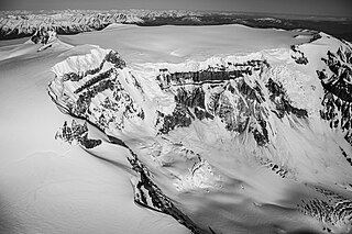
The Semeru, or Mount Semeru is an active volcano located in East Java, Indonesia. It is located in a subduction zone, where the Indo-Australian plate subducts under the Eurasia plate. It is the highest mountain on the island of Java. The name "Semeru" is derived from Meru, the central world mountain in Hinduism, or Sumeru, the abode of gods. This stratovolcano is Mahameru, meaning "The Great Mountain" in Sanskrit. It is one of the more popular hiking destinations in Indonesia.

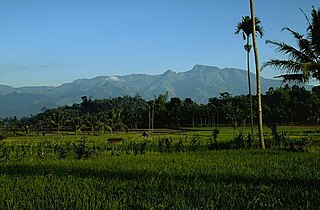
The Raung (ꦫꦲꦸꦁ), or Mount Raung is one of the most active volcanoes on the island of Java in Indonesia. It is located in the province of East Java and has a 2-kilometer-wide (1.2 mi) and 500-meter-deep (1,600 ft) caldera surrounded by a grayish rim. The difference in color of the rim and the flanks of the volcanoes is caused by the rim’s lack of vegetation compared with the healthy and extensive vegetation on the flanks. Raung, standing almost 3,332 metres (10,932 ft) above sea level, is the tallest volcano of this cluster.
Mount Edziza, sometimes called Edziza Mountain or Edziza Peak, is a stratovolcano in Cassiar Land District of northwestern British Columbia, Canada. It is located on the Big Raven Plateau of the Tahltan Highland which extends along the western side of the Stikine Plateau. The mountain has an elevation of 2,786 metres, making it the highest volcano of the Mount Edziza volcanic complex. However, it had an elevation of at least 3,396 metres before its original summit was likely destroyed by a violent, climactic eruption in the geologic past. Mount Edziza contains several lava domes, cinder cones and lava fields on its flanks, as well as an ice cap that is characterized by several outlet glaciers stretching out to lower altitudes. All sides of the mountain are drained by tributaries of Mess Creek and Kakiddi Creek which are situated within the Stikine River watershed.

Mount Sinabung is a Pleistocene-to-Holocene stratovolcano of andesite and dacite in the Karo plateau of Karo Regency, North Sumatra, Indonesia, 40 kilometres (25 mi) from the Lake Toba supervolcano. Many old lava flows are on its flanks and the last known eruption, before recent times, occurred 1200 years before present, between 740 - 880 CE. Solfataric activities were last observed at the summit in 1912; recent documented events include an eruption in the early hours of 29 August 2010 and eruptions in September and November 2013, January, February and October 2014. The volcano has recently claimed the life of at least 23 people in a number of events since 2014. Between 2013 and 2014, the alert for a major event was increased with no significant activity. On 2 June 2015, the alert was again increased, and on 26 June 2015, at least 10,000 people were evacuated, fearing a major eruption. The long eruption of Mount Sinabung is similar to that of Mount Unzen in Japan, which erupted for five years after lying dormant for 400 years. A major eruption began on 10 August 2020.

Mount Ungaran is a deeply eroded stratovolcano, located in the south of Semarang, Central Java, Indonesia. There are no historical records about the mountain's activities. Two active fumarole fields are found on the southern flanks.
Iyang-Argapura or Mount Argopuro is a massive volcanic complex that dominates the landscape between Mount Raung and Mount Lamongan in East Java, Indonesia. Valleys up to 1,000 m deep dissect the strongly eroded Iyang volcano. No historical eruptions have been recorded within the last 500 years, but there is an unverified report about an eruption in AD 1597.

Mount Ibu is a stratovolcano at the north-west coast of Halmahera island, Indonesia. The summit is truncated and contains nested craters. The inner crater is 1 km (0.62 mi) wide and 400 m (1,312 ft) deep, while the outer is 1.2 km (0.75 mi) wide. A large parasitic cone is at the north-east of the summit and a smaller one at the south-west. The latter feeds a lava flow down the west flank. A group of maars are on the western and northern side of the volcano.
Todoko-Ranu is a twin caldera complex on Halmahera island, Indonesia. The 2 km wide of lava-filled Todoko caldera is at the south of the 2 × 2.8 km wide of Ranu caldera. The Ranu caldera contains a volcanic cone Sahu and a caldera lake at the north side. No historical records are found from the caldera complex.
Mount Leura is a 313-metre scoria cone surrounding a dry crater 100 m deep and is the central and most obvious component of a larger volcanic complex southeast of the town of Camperdown located in western Victoria, Australia, 194 kilometres (121 mi) south west of the state capital, Melbourne. The inactive volcano is thought to have last erupted between 5,000 and 20,000 years ago. The name means "big nose" in local aboriginal dialect.

Lumajang Regency is a Regency (kabupaten) located in the East Java province of Indonesia. It covers an area of 1,790.90 sq. km, and had a population of 1,006,458 at the 2010 Census and 1,119,251 at the 2020 Census. The mid 2022 official estimate was originally stated to be 1,137,230, but was revised down to 1,097,504. The official estimate for mid 2023 was 1,108,487. The regency shares its land borders with Jember Regency, Probolinggo Regency, and Malang Regency, while it borders the Indian Ocean to the south.

Ranu Kumbolo is a mountainous lake located in Bromo Tengger Semeru National Park, East Java, Indonesia. The lake is part of the easiest route from Ranu Pani to Mount Semeru Peak.

Ranu Pani or Ranupani is a volcanic lake in Ranu Pani Village, Senduro District, Lumajang Regency, East Java. Ranu Pani is part of the Bromo Tengger Semeru National Park (TNBTS). Initially, the area of Ranu Pani was around one hectare, but now it is estimated to be only 0.75 hectares due to the rapid sedimentation rate. The population of Ranu Pani is around 2,000 people.

A volcanic crater lake is a lake in a crater that was formed by explosive activity or a collapse during a volcanic eruption.


