
Olympus Mons is a large shield volcano on Mars. It is over 21.9 km high, as measured by the Mars Orbiter Laser Altimeter (MOLA), and is about two and a half times Mount Everest's height above sea level. It is one of Mars's largest volcanoes, its tallest planetary mountain, and is approximately tied with Rheasilvia as the tallest mountain currently discovered in the Solar System. It is associated with the Tharsis Montes, a large volcanic region on Mars. It last erupted 25 million years ago.

The Ring of Fire is a tectonic belt, about 40,000 km (25,000 mi) long and up to about 500 km (310 mi) wide, which circumscribes the Pacific Ocean. It contains between 750 and 915 volcanoes, around two-thirds of the world total, and 90% of the world's earthquakes, including 81% of its largest, take place within the belt.

Prambanan is a 9th-century Hindu temple compound in the Special Region of Yogyakarta, in southern Java, Indonesia, dedicated to the Trimūrti, the expression of God as the Creator (Brahma), the Preserver (Vishnu) and the Destroyer (Shiva). The temple compound is located approximately 17 kilometres (11 mi) northeast of the city of Yogyakarta on the boundary between Central Java and Yogyakarta provinces.

Tangkuban Perahu is a stratovolcano 30 km north of the city of Bandung, the provincial capital of West Java, Indonesia. It erupted in 1826, 1829, 1842, 1846, 1896, 1910, 1926, 1929, 1952, 1957, 1961, 1965, 1967, 1969, 1983, 2013 and 2019. It is a popular tourist attraction where tourists hike or ride to the edge of the crater to view the hot water springs and boiling mud up close, and buy eggs cooked on the hot surface. Together with Mount Burangrang and Bukit Tunggul, it is a remnant of the ancient Mount Sunda after the plinian eruption caused the Caldera to collapse.

Augustine Volcano is a stratovolcano in Alaska consisting of a central complex of summit lava domes and flows surrounded by an apron of pyroclastic, lahar, avalanche, and ash deposits. The volcano is frequently active, with major eruptions recorded in 1883, 1935, 1963–64, 1976, 1986, and 2006. Minor eruptive events were reported in 1812, 1885, 1908, 1944, and 1971. The large eruptions are characterized by an explosive onset followed by the quieter effusion of lava. It forms Augustine Island in southwestern Cook Inlet in the Kenai Peninsula Borough of southcentral coastal Alaska, 174 miles (280 km) southwest of Anchorage. Augustine Island has a land area of 32.4 square miles (83.9 km2), while West Island, just off Augustine's western shores, has 2 sq mi (5.2 km2). The irregular coastline of Augustine Island is due to the repeated catastrophic collapse of the summit dome, forming debris avalanches down the flanks and into Cook Inlet.

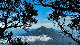
The Raung (ꦫꦲꦸꦁ), or Mount Raung is one of the most active volcanoes on the island of Java in Indonesia. It is located in the province of East Java and has a 2-kilometer-wide (1.2 mi) and 500-meter-deep (1,600 ft) caldera surrounded by a grayish rim. The difference in color of the rim and the flanks of the volcanoes is caused by the rim’s lack of vegetation compared with the healthy and extensive vegetation on the flanks. Raung, standing almost 3,332 metres (10,932 ft) above sea level, is the tallest volcano of this cluster.
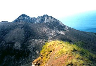
Iliwerung or Illiwerung is a complex volcano forming a prominent south-facing peninsula on Lembata Island in southern Indonesia. It contains north-south and northwest-southeast trending lines of craters and lava domes, with the summit dome having formed by a VEI-3 eruption in 1870.
Jailolo is a volcanic complex on a peninsula, west of Halmahera island. It has lava flows on the eastern flank, small caldera at the west and south-west of the mountain, hot springs along the north-west coast of the caldera. Small volcanic island was formed by the Kailupa cone, off the southern coast of the peninsula.
Dukono is an active volcano located in the northern part of Halmahera island, Indonesia. It has a broad profile and is capped by compound craters. During the major eruption in 1550, a lava flow filled in the strait between Halmahera and the north flank cone of Mount Mamuya. It was an eruption of scale 3 on VEI. Deaths were reported but the figure is unknown. Smaller eruptions occurred in 1719, 1868, and 1901. Since 1933, Dukono has been erupting continuously until the present.

Mount Sinabung is a Pleistocene-to-Holocene stratovolcano of andesite and dacite in the Karo plateau of Karo Regency, North Sumatra, Indonesia, 40 kilometres (25 mi) from the Lake Toba supervolcano. Many old lava flows are on its flanks and the last known eruption, before recent times, occurred 1200 years before present, between 740 - 880 CE. Solfataric activities were last observed at the summit in 1912; recent documented events include an eruption in the early hours of 29 August 2010 and eruptions in September and November 2013, January, February and October 2014. The volcano has recently claimed the life of at least 23 people in a number of events since 2014. Between 2013 and 2014, the alert for a major event was increased with no significant activity. On 2 June 2015, the alert was again increased, and on 26 June 2015, at least 10,000 people were evacuated, fearing a major eruption. The long eruption of Mount Sinabung is similar to that of Mount Unzen in Japan, which erupted for five years after lying dormant for 400 years. A major eruption began on 10 August 2020.

Mount Salak is an eroded volcano in West Java, Indonesia. It has several satellite cones on its southeast flank and the northern foot, along with two additional craters at the summit. Mount Salak has been evaluated for geothermal power development. According to a popular belief, the name "Salak" is derived from salak, a tropical fruit with scaly skin; however, according to Sundanese tradition, the name was derived from the Sanskrit word Salaka which means "silver". Mount Salak can be translated to "Silver Mountain" or "Mount Silver".

Mount Slamet is an active stratovolcano in the Purbalingga Regency of Central Java, Indonesia. It has a cluster of around three dozen cinder cones on the lower southeast-northeast flanks and a single cinder cone on the western flank. The volcano is composed of two overlapping edifices. Four craters are found at the summit. Mount Slamet is a mountain with the coldest average temperature on the island of Java and one of the areas with the highest annual rainfall in Indonesia, namely 8,134.00 millimeters (mm) per year.
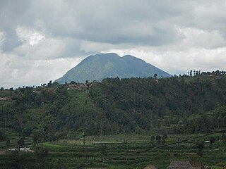
Mount Sindoro, Mount Sindara or Mount Sundoro is an active stratovolcano in Central Java, Indonesia. Parasitic craters and cones are found in the northwest-southern flanks; the largest is called Kembang. A small lava dome occupies the volcano's summit. Historical eruptions have been mostly mild to moderate.

Mount Ungaran is a deeply eroded stratovolcano, located in the south of Semarang, Central Java, Indonesia. There are no historical records about the mountain's activities. Two active fumarole fields are found on the southern flanks.
Mount Telomoyo is a stratovolcano in Central Java, Indonesia. The volcano was constructed over the southern flank of the eroded Pleistocene-age Soropati volcano, which has a height of 1,300 metres (4,300 ft). The Soropati volcano collapsed during the Pleistocene, leaving a U-shaped depression. Mount Telomoyo grows on the southern side of the depression, reaching over 600 metres (2,000 ft) above the depression's rim.

Mount Lamongan or Mount Lemongan is a small stratovolcano located between the massif Tengger caldera complex and Iyang-Argapura volcano complex in East Java, Indonesia. The volcano is surrounded by maars and cinder cones. The volcano's high point is locally named as Gunung Tarub. Lake-filled maars including Ranu Pakis, Ranu Klakah and Ranu Bedali, located on the eastern and western flanks. The northern flanks are dominated by dry maars.

Mount Awu is the largest volcano in the Sangihe chain, located on Sangir Island in North Sulawesi, Indonesia. Powerful eruptions occurred in 1711, 1812, 1856, 1822, 1892, and 1966 with devastating pyroclastic flows and lahars that have resulted in 11,048 fatalities. A total of 18 eruptions are recorded from 1640, with two of VEI 4 and 3 with VEI 3, one eruption every ~ 20 years. The hazardous nature of the volcano is determined from the continuous lava source driven by the geodynamic setting and the presence of a crater lake, sustained by the consistent rainfall on the island, on top of a lava dome. This setting creates the conditions for water injection in the lava dome, which can cause a water-magma explosion.

Tharsis Tholus is an intermediate-sized shield volcano located in the eastern Tharsis region of the planet Mars. The volcano was discovered by the Mariner 9 spacecraft in 1972 and originally given the informal name Volcano 7. In 1973, the International Astronomical Union (IAU) officially designated it Tharsis Tholus. In planetary geology, tholus is the term for a small domical mountain, usually a volcano.

The volcanic history of the Northern Cordilleran Volcanic Province presents a record of volcanic activity in northwestern British Columbia, central Yukon and the U.S. state of easternmost Alaska. The volcanic activity lies in the northern part of the Western Cordillera of the Pacific Northwest region of North America. Extensional cracking of the North American Plate in this part of North America has existed for millions of years. Continuation of this continental rifting has fed scores of volcanoes throughout the Northern Cordilleran Volcanic Province over at least the past 20 million years and occasionally continued into geologically recent times.
