Armenia is a landlocked country in the South Caucasus region of the Caucasus. The country is geographically located in West Asia, within the Armenian plateau. Armenia is bordered on the north and east by Georgia and Azerbaijan and on the south and west by Iran, Azerbaijan's exclave Nakhchivan, and Turkey.
The Seven Summits are the highest mountains on each of the seven traditional continents. Reaching the peak of these summits is considered a significant achievement amongst many mountaineers, alongside many other such goals and challenges in the mountaineering community. On 30 April 1985, Richard Bass became the first climber to reach the summit of all seven.

Mount Elbrus is the highest mountain in Russia and Europe. It is situated in the western part of the North Caucasus and is the highest peak of the Caucasus Mountains. The dormant volcano rises 5,642 m (18,510 ft) above sea level; it is the highest stratovolcano in Eurasia and the 10th-most prominent peak in the world. The mountain stands in Southern Russia, in the Russian republic of Kabardino-Balkaria.

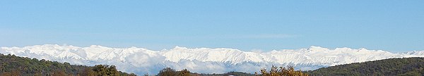
The Caucasus Mountains is a mountain range at the intersection of Asia and Europe. Stretching between the Black Sea and the Caspian Sea, they are surrounded by the Caucasus region and are home to Mount Elbrus, the highest peak in Europe at 5,642 metres (18,510 ft) above sea level.

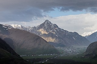
Mount Kazbek or Mount Kazbegi is a dormant stratovolcano and one of the major mountains of the Caucasus, located in Georgia, just south of the border with Russia.

The Georgian Military Road or Georgian Military Highway also known as Ghalghaï Military Road, is the historic name for a major route through the Caucasus from Georgia to Russia. Alternative routes across the mountains include the Ossetian Military Road and the Transcaucasian Highway.
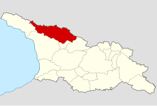
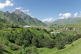
Svaneti or Svanetia is a historic province in the northwestern part of Georgia. Running along the Greater Caucasus range, Svaneti is one of the most mountainous regions of Georgia. It is largely inhabited by the Svans, an ethnic subgroup of Georgians.
This is a list of the extreme points of Europe: the geographical points that are higher or farther north, south, east or west than any other location in Europe. Some of these positions are open to debate, as the definition of Europe is diverse.

The Battle of the Caucasus was a series of Axis and Soviet operations in the Caucasus as part of the Eastern Front of World War II. On 25 July 1942, German troops captured Rostov-on-Don, opening the Caucasus region of the southern Soviet Union to the Germans and threatening the oil fields beyond at Maikop, Grozny, and ultimately Baku. Two days prior, Adolf Hitler had issued a directive to launch an operation into the Caucasus named Operation Edelweiß. German forces were compelled to withdraw from the area that winter as Operation Little Saturn threatened to cut them off.

Shkhara is the highest point in the country of Georgia. It is located near the Russian-Georgian border, in Russia's Kabardino-Balkaria region on the northern side, and the Svaneti region of Georgia in the south. Shkhara lies 88 kilometres (55 mi) north of the city of Kutaisi, Georgia's second-largest city, and closer to the townlet of Mestia in Svaneti. The summit lies in the central part of the Greater Caucasus Mountain Range, to the south-east of Mount Elbrus, Europe's highest mountain. Shkhara is the third-highest peak in the Caucasus, just behind Dykh-Tau.
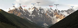
Janga or Jangi-Tau or Dzhangi-Tau is a summit in the central part of the Greater Caucasus Mountain Range. Mountain has three peaks - the main peak Jangi-Tau with elevation above sea level 5,085 m (16,683 ft), West Peak with elevation 5,059 m (16,598 ft) and East Peak with elevation 5,034 m (16,516 ft) Mountain lies on the border of Svaneti (Georgia) and Kabardino-Balkaria (Russia). The slopes of the mountain are heavily glaciated. They are most famous for the dormant volcanoes that are hidden under the ice caps.
Khevi is a small historical-geographic area in northeastern Georgia. It is included in the modern-day Kazbegi district, Mtskheta-Mtianeti region (mkhare). Located on the northern slopes of the Greater Caucasus mountains, it comprises three gorges of the rivers Truso, Tergi (Terek) and Snostsq’ali.
Mount Khabarjina is a mountain and dormant volcano in the Caucasus of Georgia. It has an elevation of 3,142 metres. It is located near Mount Kazbek and is a part of its volcanic group. It is better known under the name Mount Kabardzhin.

The Seven Second Summits are the second-highest mountains of each of the seven continents. All of these mountains are separate peaks rather than a sub-peak of the continents' high point. The Seven Second Summits are considered a harder challenge than the traditional Seven Summits.

Dykh-Tau or Dykhtau, is the second-highest mountain in Russia and Europe, standing at 5,205 m above sea level. It is located in Kabardino-Balkaria, Russia; its peak standing about 5 km (3 mi) north of the border with Georgia.

Kazbegi is a district of Georgia, in the region of Mtskheta-Mtianeti in east-north Georgia.

Gergeti is a glacier located on the southeastern slope of Mt. Kazbek in the Kazbegi District of Georgia. The length of the Gergeti glacier is 7.1 km (4.4 mi) and its surface area is 11 km2 (4.2 sq mi). The tongue of Gergeti descends to 2,900 metres (9,500 ft) above sea level. Most of the glacier is located within an old and eroded volcanic caldera, where, at the edge of the caldera's northern rim, rises the cone of Mt. Kazbek. The southern rim of the caldera where the glacier descends, is bounded by Mount Ortsveri. There is a meteorological station located on the left edge of the Gergeti Glacier at an elevation of 3,650 m (11,980 ft) above sea level.

The southernmost persistent glacial masses in Europe are mainly small glaciers, glacierets, and perennial firn fields and patches, located in the highest mountains of the three big southern European peninsulas - the Balkan, the Apennine, and the Iberian, the southernmost ranges of the Alps and the glaciers on the european northwestern slopes of the Greater Caucasus mountains in Russia. There are summer lasting snow patches in Sierra Nevada, in Mount Olympus (40°05′08″), in Mount Korab (41°47′28″), in Rila Mountain, in Picos de Europa (43°11′51″) in the Cantabrian Mountains, in Mount Maglić (43°16′52″) and others. However, none of them have both persistency and indications of dynamic motion. In southern direction, some 4000 km away, are the glaciers in Africa in Rwenzori Mountains (00°23′09″N), Mount Kenya (00°09′03″S) and Mount Kilimanjaro (03°04′33″S).