
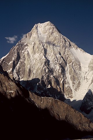
K2, at 8,611 metres (28,251 ft) above sea level, is the second-highest mountain on Earth, after Mount Everest at 8,849 metres (29,032 ft). It lies in the Karakoram range, partially in the Gilgit-Baltistan region of Pakistan-administered Kashmir and partially in the China-administered Trans-Karakoram Tract in the Taxkorgan Tajik Autonomous County of Xinjiang.

The Karakoram is a mountain range in the Kashmir region spanning the border of Pakistan, China, and India, with the northwestern extremity of the range extending to Afghanistan and Tajikistan. Most of the Karakoram mountain range falls under the jurisdiction of Gilgit-Baltistan, which is controlled by Pakistan. Its highest peak, K2, is located in Gilgit-Baltistan, Pakistan. It begins in the Wakhan Corridor (Afghanistan) in the west, encompasses the majority of Gilgit-Baltistan, Pakistan and extends into Ladakh and Aksai Chin. It is part of the larger Trans-Himalayan mountain ranges.

The eight-thousanders are the 14 mountains recognized by the International Mountaineering and Climbing Federation (UIAA) as being more than 8,000 metres (26,247 ft) in height above sea level, and sufficiently independent of neighbouring peaks. There is no precise definition of the criteria used to assess independence, and at times, the UIAA has considered whether the list should be expanded to 20 mountain peaks by including the major satellite peaks of eight-thousanders. All of the eight-thousanders are located in the Himalayan and Karakoram mountain ranges in Asia, and their summits lie in the altitude range known as the death zone.

Dhaulagiri, located in Nepal, is the seventh highest mountain in the world at 8,167 metres (26,795 ft) above sea level, and the highest mountain within the borders of a single country. It was first climbed on 13 May 1960 by a Swiss-Austrian-Nepali expedition. Annapurna I is 34 km (21 mi) east of Dhaulagiri. The Kali Gandaki River flows between the two in the Kaligandaki Gorge, said to be the world's deepest. The town of Pokhara is south of the Annapurnas, an important regional center and the gateway for climbers and trekkers visiting both ranges as well as a tourist destination in its own right.
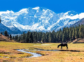
Nanga Parbat, known locally as Diamer, is the ninth-highest mountain on Earth and its summit is at 8,126 m (26,660 ft) above sea level. Lying immediately southeast of the northernmost bend of the Indus River in the Gilgit-Baltistan region of Pakistan-administered Kashmir, Nanga Parbat is the westernmost major peak of the Himalayas, and thus in the traditional view of the Himalayas as bounded by the Indus and Yarlung Tsangpo/Brahmaputra rivers, it is the western anchor of the entire mountain range.

Gasherbrum I, surveyed as K5 and also known as Hidden Peak, is the 11th highest mountain in the world at 8,080 metres (26,510 ft) above sea level. It is located between Shigar District in the Gilgit–Baltistan region of Pakistan and Tashkurgan in the Xinjiang of China. Gasherbrum I is part of the Gasherbrum Massif, located in the Karakoram region of the Himalaya. Gasherbrum is often claimed to mean "Shining Wall", presumably a reference to the highly visible face of the neighboring peak Gasherbrum IV; but in fact, it comes from "rgasha" (beautiful) + "brum" (mountain) in Balti, hence it actually means "beautiful mountain."

Broad Peak is one of the eight-thousanders, and is located in the Karakoram range spanning Gilgit-Baltistan, Pakistan and Xinjiang, China. It is the 12th highest mountain in the world with 8,051 metres (26,414 ft) elevation above sea level. The first ascent of this mountain was in June 1957, accomplished by Fritz Wintersteller, Marcus Schmuck, Kurt Diemberger, and Hermann Buhl as part of an Austrian expedition.

Gasherbrum II ; surveyed as K4, is the 13th highest mountain in the world at 8,035 metres (26,362 ft) above sea level. It is the third-highest peak of the Gasherbrum massif, and is located in the Karakoram, on the border between Gilgit–Baltistan, Pakistan and Xinjiang, China. The mountain was first climbed on July 7, 1956, by an Austrian expedition which included Fritz Moravec, Josef Larch, and Hans Willenpart.

Chogolisa is a trapezoidal mountain located in the Karakoram range within the Gilgit-Baltistan region of Pakistan. It is situated near the Baltoro Glacier in the Concordia region, which is renowned for hosting some of the world's tallest peaks.
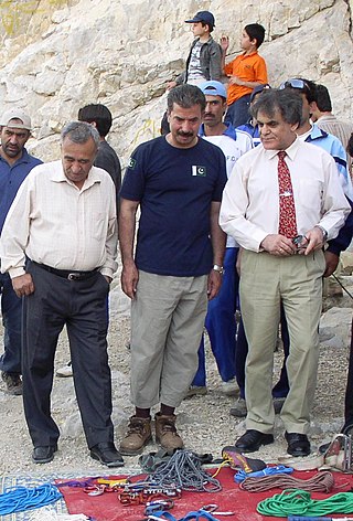
Nazir Sabir is a Pakistani mountaineer. He was born in Hunza. He has climbed Mount Everest and four of the five 8000 m peaks in Pakistan, including the world's second highest mountain K2 in 1981, Gasherbrum II 8035m, Broad Peak 8050m in 1982, and Gasherbrum I 8068m in 1992. He became the first from Pakistan to have climbed Everest on 17 May 2000 as a team member on the Mountain Madness Everest Expedition led by Christine Boskoff from the United States that also included famed Everest climber Peter Habeler of Austria and eight Canadians.
Gasherbrum IV, surveyed as K3, is the 17th highest mountain on Earth and the 6th highest in Pakistan, as well as the highest independent mountain under eight thousand meters in Pakistan.

Noshaq, also called Noshakh or Nowshakh, is the second highest peak in the Hindu Kush Range after Tirich Mir at 7,492 m (24,580 ft). It lies on the border between Afghanistan and Pakistan. The north and west sides of the mountain are in Afghanistan whereas the south and eastern sides are in Pakistan. Noshaq is Afghanistan's highest mountain and is located in the northeastern corner of the country along the border with Pakistan. It is the westernmost 7,000 m (22,966 ft) peak in the world. Easiest access to Noshaq is from Wakhan Afghanistan.

Torghar District formerly known as Kala Dhaka is a district in the Hazara Division of the Khyber Pakhtunkhwa province of Pakistan. It was officially separated from Mansehra District in 2011 under Article 246 of the Constitution of the Islamic Republic of Pakistan.
Spantik, or Golden Peak, is a mountain situated in the subrange within the Karakoram range. It is located in the Arandu Valley, Shigar District, within the Gilgit-Baltistan region of Pakistan. The northwest face of Spantik is dominated by a pronounced pillar of creamy yellow marble which reaches up its north face to 300 m below the summit. Its distinctive appearance has given the peak its Buruskaski name, "Ganesh Chish" or Golden Peak. This outcropping is renowned for its exceptionally challenging climbing route, famously referred to as the "Golden Pillar."
Bagrot Valley is a valley in the Karakoram range in the Gilgit-Baltistan region of northern Pakistan. River Bagrot flows through the valley from the north to the southwest, supplying water to the settlements of Jalalabad and Oshikhandass before merging with the Gilgit River.
Colonel Narendra Kumar, PVSM, KC, AVSM, FRGS was an Indian soldier and mountaineer. He is known for his expeditions across various mountain ranges such as the Himalayas and Karakorams, and respective subranges such as the Pir Panjals and Saltoro Mountains. His reconnaissance efforts on the Siachen glacier were key to the Indian Army's reclamation of the forward posts of the glacier in Operation Meghdoot in 1984. He was the deputy leader of the first successful Indian Mount Everest expedition in 1965.
Eduard "Edi" Koblmueller was an Austrian mountaineer.

James (Jack) Daulton, also known as Nyi Nyi Min, is an American art collector, trial lawyer, music entrepreneur, exploration philanthropist, and expert and lecturer on the history of art and architecture. Daulton rose to fame representing the nation of Myanmar in the groundbreaking 1994 legal case, United States v. Richard Diran and The Union of Myanmar, successfully recovering a 1,000-year-old Buddha statue that had been stolen in 1988 from a temple in Myanmar's ancient capital, Bagan, a treasure now on display in the National Museum in Yangon. This was the first cultural property claim litigated by a Southeast Asian nation in the United States. Daulton has also gained recognition as a result of The Daulton Collection–his vast art collection which includes one of the world's largest private collections of German Symbolist art and, in particular, the world's largest collection of works by a number of individual artists, such as the eccentric monkey painter Gabriel von Max, the Austrian symbolist Rudolf Jettmar, and the proto-hippie Fidus. Among The Daulton Collection's highlights are masterpieces of symbolist portraiture, including Karl Gussow's Portrait of the Novelist Ossip Schubin (1887), Rudolf Jettmar's Self-Portrait of the Young Artist (1896), and Oskar Zwintscher's The Woman in Hamster (1914), currently on long-term loan to the Albertinum, Staatliche Kunstsammlungen, the museum of modern art in Dresden. In 2021, a painting from The Daulton Collection, Gabriel von Max's Abelard and Heloise, was the "face" of the major exhibition at the Musée d'Orsay, Paris, "Les Origines du Monde: L'invention de la nature au XIXe siècle". In addition, Daulton is well known as an expert on non-western art, architecture, and religion, and acclaimed for his many lectures on those subjects for institutions such as National Geographic, The American Museum of Natural History, and The Art Institute of Chicago. He is also well known for his activity in exploration philanthropy, funding research expeditions around the globe, from archaeological digs in the Peruvian Andes to language documentation projects on remote atolls in Micronesia. And as an art and entertainment lawyer in the 1990s, Daulton developed the major-label rock band Kill Hannah, among other recording artists.


