Chumathang | |
|---|---|
Village | |
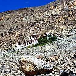 Chumathang gompa | |
 Chumathang Location in Ladakh, India  Chumathang Chumathang (India) | |
| Coordinates: 33°22′N78°20′E / 33.36°N 78.34°E | |
| Country | India |
| Union Territory | Ladakh |
| District | Leh |
| Tehsil | Nyoma |
| Elevation | 3,950 m (12,960 ft) |
| Population (2011) | |
• Total | 641 |
| Languages | |
| • Official | Hindi, English |
| • Spoken | Laddakh, Boti |
| Time zone | UTC+5:30 (IST) |
| PIN | 194201 |
| Census code | 900 |

Chumathang is a village in Leh District, Ladakh in northern India on the banks of the Indus River. Chumathang village is among the first villages in the Changthang region to have its own power station and government high school which was only possible under the guidance of Hemis and Chemday Monastery. Famous for its hot spring which attracts many tourists all over the world, even the local people come every year to take the medicinal benefits from the hot spring. There is an old monastery or gonpa which is located near the road which is about more than 400 years old and is among the oldest monasteries of Ladakh.
