History of Ladakh

Last updated

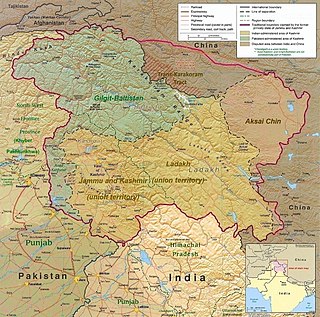
A map of the disputed Kashmir region showing the Indian-administered territory of Ladakh Kashmir Region November 2019.jpg
A map of the disputed Kashmir region showing the Indian-administered territory of Ladakh
Hemis Monastery in the 1870s Hemis Monastery Ladakh 1876.jpg
Hemis Monastery in the 1870s

Ladakh has a long history with evidence of human settlement from as back as 9000 b.c. It has been a crossroad of high Asia for thousands of years and has seen many cultures, empires and technologies born in its neighbours. As a result of these developments Ladakh has imported[ clarification needed ] many traditions and culture from its neighbours and combining them all gave rise to a unique tradition and culture of its own.

Contents

Earliest history

The first glimpse of political history is found in the kharosthi inscription of "Uvima Kavthisa" discovered near the K'a-la-rtse (Khalatse) bridge on the Indus, showing that in around the 1st century, Ladakh was a part of the Kushan Empire. A few other short Brahmi and Kharosthi inscriptions have been found in Ladakh.[ citation needed ]

The Chinese pilgrim monk Xuanzang, c. 634 CE, described a journey from Chuluduo (Kūluta, Kulu) to Luohuluo (Lahul) and then states that, "[f]rom here, the road, leading to the north, for over one thousand, eight hundred or nine hundred li by perilous paths and over mountains and valleys, takes one to the country of Lāhul. Going further to the north over two thousand li along a route full of difficulties and obstacles, in cold winds and wafting snowflakes, one could reach the country of Marsa (also known as Sanbohe)." [1] The kingdom of Moluosuo, or Mar-sa, would seem to be synonymous with Mar-yul, a common name for Ladakh. Elsewhere, the text remarks that Mo-lo-so, also called San-po-ho borders with Suvarnagotra or Suvarnabhumi (Land of Gold), identical with the Kingdom of Women (Strirajya). According to Tucci, the Zhangzhung kingdom, or at least its southern districts, were known by this name by the 7th-century Indians. In 634/5 Zhangzhung acknowledged Tibetan suzernaity for the first time, and in 653 a Tibetan commissioner (mnan) was appointed there. Regular administration was introduced in 662, and an unsuccessful rebellion broke out in 677.

In the 8th century, Ladakh was caught between Tibetan expansion pressing from the east, and Chinese influence exerted from Central Asia through the passes. In 719 a census was taken, and in 724 the administration was reorganized. In 737, the Tibetans launched an attack against the king of Bru-za (Gilgit), who asked for Chinese help, but was ultimately forced to pay homage to Tibet. The Korean monk Hyecho (704-787) (pinyin: Hui Chao), reached India by sea and returned to China in 727 via central Asia. [2] He referred to three kingdoms lying to the northeast of Kashmir which were:

"under the suzerainty of the Tibetans. . . . The country is narrow and small, and the mountains and valleys very rugged. There are monasteries and monks, and the people faithfully venerate the Three Jewels. As to the kingdom of Tibet to the East, there are no monasteries at all, and the Buddha's teaching is unknown; but, in [these] countries, the population consists of Hu; therefore, they are believers. (Petech, The Kingdom of Ladakh, p. 10)." [3]

Rizvi points out that this passage not only confirms that, in the early 8th century, the region of modern Ladakh was under Tibetan suzerainty, but that the people belonged to non-Tibetan stock.

In 747, the hold of Tibet was loosened by the campaign of Chinese General Gao Xianzhi, who tried to re-open the direct communications between Central Asia and Kashmir. After Gao's defeat by the Qarluqs and Arabs on the Talas river (751), Chinese influence decreased rapidly and Tibetan influence resumed.

The geographical treatise Hudud-al-Alam (982) mentions Bolorian (Bolor = Bolu, Baltistan) Tibet, where people were chiefly merchants and lived in huts. Nestorian crosses carved into boulders, apparently due to Sogdian Christian merchants found in Drangtse (Tangtse), and Arabic inscriptions of about the same time are evidence of the importance of trade in this region. After the collapse of the Tibetan monarchy in 842, Tibetan suzerainty quickly vanished.

La-Chen/Gon dynasty:The first dynasty

Royal drinking scene at Alchi Monastery circa 1200 CE. The king wears a decorated Qaba', of Turco-Persian style. It is similar to another royal scene at nearby Mangyu Monastery. Royal drinking scene in the Dukhang at Alchi Monastery, circa 1200 CE.jpg
Royal drinking scene at Alchi Monastery circa 1200 CE. The king wears a decorated Qabā', of Turco-Persian style. It is similar to another royal scene at nearby Mangyu Monastery.

After the breakup of the Tibetan Empire in 842, Nyima-Gon, a representative of the ancient Tibetan royal house founded the first Ladakh dynasty. Nyima-Gon's kingdom had its centre well to the east of present-day Ladakh. This was the period in which Ladakh underwent Tibetanization, eventually making Ladakh a country inhabited by a mixed population, the predominant racial strain of which was Tibetan. However, soon after the conquest, the dynasty, intent on establishing Buddhism, looked not to Tibet, but to north-west India, particularly Kashmir. This has been termed the Second Spreading of Buddhism in the region (the first one being in Tibet proper.)[ citation needed ] An early king, Lde-dpal-hkhor-btsan (c. 870 -900), swore an oath to develop the Bön religion in Ladakh and was responsible for erecting eight early monasteries including the Upper Manahris monastery. He also encouraged the mass production of the Hbum scriptures to spread religion. [5] Little, however is known about the early kings of Nyima-Gon's dynasty. The fifth king in line has a Sanskrit name, Lhachen Utpala, who conquered Kulu, Mustang, and parts of Baltistan. [6]

Around the 13th century, due to islamic invasions, India ceased having anything to offer from a Buddhist point of view, and Ladakh began to seek and accept guidance in religious matters from Tibet.

The Namgyal dynasty

Continual raids on Ladakh by the plundering Muslim states of Central Asia lead to the weakening and partial conversion of Ladakh. [7] [8] Ladakh was divided, with Lower Ladakh ruled by King Takpabum from Basgo and Temisgam, and Upper Ladakh by King Takbumde from Leh and Shey. Lhachen Bhagan, a later Basgo king, reunited Ladakh by overthrowing the king of Leh. He took on the surname Namgyal (meaning victorious) and founded a new dynasty which still survives today. King Tashi Namgyal (1555–1575) managed to repel most Central Asian raiders, and built a royal fort on the top of the Namgyal Peak. Tsewang Namgyal temporarily extended his kingdom as far as Nepal. [8]

The Leh Palace, built by Sengge Namgyal Leh Palace 2011.jpg
The Leh Palace, built by Sengge Namgyal

During the reign of Jamyang Namgyal, Ladakh was invaded by Balti ruler Ali Sher Khan Anchan in response to Jamyang's killing of some Muslim rulers of Baltistan. Many Buddhist gompas were damaged during Khan's invasion. Today, few gompas exist from before this period. The success of Khan's campaign impressed his enemies. According to some accounts, Jamyang secured a peace treaty and gave his daughter's hand in marriage to Ali Sher Khan. Jamyang was given the hand of a Muslim princess, Gyal Khatun's hand in marriage. Sengge Namgyal (1616–1642), known as the 'lion' king was the son of Jamyang and Gyal. [8] [9] [10] [11] [12] [13] [14] [15] He made efforts to restore Ladakh to its old glory by an ambitious and energetic building programme by rebuilding several gompas and shrines, the most famous of which is Hemis. He also moved the royal headquarters from Shey Palace to Leh Palace and expanded the kingdom into Zanskar and Spiti, but was defeated by the Mughals, who had already occupied Kashmir and Baltistan. His son Deldan Namgyal (1642–1694) had to placate the Mughal emperor Aurangzeb by building a mosque in Leh. [7] [8] However, he later with the help of the Mughal Army under Fidai Khan, son of Mughal viceroy of Kashmir, Ibrahim Khan, defeated the 5th Dalai Lama invasion in the plains of Chargyal, situated between Neemoo and Basgo. [8]

Many Muslim missionaries propagated Islam during this period in Ladakh and proselytised many Ladakhi people. Many Balti Muslims settled in Leh after the marriage of Jamyang to Gyal. Muslims were also invited to the region for trading and other purposes. [16] [17]

Modern times

Princely state of Jammu and Kashmir

By the beginning of the 19th century, the Mughal Empire had collapsed, and Sikh rule had been established in Punjab and Kashmir. However the Dogra region of Jammu remained under its Rajput rulers. Raja Gulab Singh, acting under the suzerainty of the Sikh monarch Ranjit Singh, sent his general Zorawar Singh to invade Ladakh in 1834. King Tshespal Namgyal was dethroned and exiled to Stok. Ladakh came under Dogra rule and was later incorporated into the princely state of Jammu and Kashmir under British suzerainty. It still maintained considerable autonomy and relations with Tibet. During the Dogra–Tibetan War (1841–42), Tibet invaded Ladakh and the Ladakhis attempted to overthrow the Dogras with Tibetan help, but all of them were defeated. The Namgyal family was given the jagir of Stok, which it nominally retains to this day. European influence began in Ladakh in the 1850s and increased. Geologists, sportsmen, and tourists began exploring Ladakh. In 1885, Leh became the headquarters of a mission of the Moravian Church.

Ladakh was administered as a wazarat during the Dogra rule, with a governor termed wazir-e-wazarat. It had three tehsils, based at Leh, Skardu and Kargil. The headquarters of the wazarat was at Leh for six months of the year and at Skardu for six months. When the legislative assembly called Praja Sabha was established in 1934, Ladakh was given two nominated seats in the assembly.

Administrators of Ladakh (1846–1905)
MaharajaAdministrators

(a.k.a. Thanedar, Wazir Wazarat,

Kardar, Governor)

StartEndRef
Gulab Singh

(1846–1857)

Magna Thanedar [lower-alpha 1] 18461847 [18] [19]
Mehta Basti Ram 18471860 [20] [19]
Ranbir Singh

(1857–1885)

Mehta Mangal Singh [lower-alpha 2] 18601865 [21] [22]
Wazir Shibsarn18651867 [21] [23]
Sayyid Akbar Ali18671868 [21] [24]
Frederic Drew 18681870 [21] [25]
William H. Johnson 18701881/83 [26] [21] [25]
Radha Krishen Kaul1885- [27] [25]
Pratap Singh

(1885–1925)

Chaudhri Khushi Mohammad19081909 [27] [25]
Administrative borders of Ladakh, Gilgit and Baltistan undergo changes
---
Hari Singh

(1925–1952)

---

Ladakh was claimed as part of Tibet by Phuntsok Wangyal, a Tibetan Communist leader. [28]

Indian state of Jammu and Kashmir

In 1947, partition left Ladakh a part of the Indian state of Jammu and Kashmir, to be administered from Srinagar. In 1948, Pakistani raiders invaded Ladakh and occupied Kargil and Zanskar, reaching within 30 km of Leh. [8] Reinforcement troops were sent in by air, and a battalion of Gurkhas made its way slowly to Leh on foot from south. Kargil was a scene of fighting again in 1965, 1971, and 1999.

In 1949, China closed the border between Nubra and Sinkiang, blocking the 1000-year-old trade route from India to Central Asia. In 1950, China invaded Tibet, and thousands of Tibetans, including the Dalai Lama sought refuge in India. In 1962, China occupied Aksai Chin, and promptly built roads connecting Xinjiang and Tibet, and the Karakoram Highway, jointly with Pakistan. India built the Srinagar-Leh highway during this period, cutting the journey time between Srinagar to Leh from 16 days to two. Simultaneously, China closed the Ladakh-Tibet border, ending the 700-year-old Ladakh-Tibet relationship. [8]

Since the early 1960s the number of immigrants from Tibet (including Changpa nomads) have increased as they flee the occupation of their homeland by the Chinese. Today, Leh has some 3,500 refugees from Tibet. They hold no passports, only customs papers. Some Tibetan refugees in Ladakh claim dual Tibetan/Indian citizenship, although their Indian citizenship is unofficial. Since partition Ladakh has been governed by the State government based in Srinagar, never to the complete satisfaction of the Ladakhis, who demand that Ladakh be directly governed from New Delhi as a Union Territory. They allege continued apathy, Muslim bias, and corruption of the state government as reasons for their demands. In 1989, there were violent riots between Buddhists and Muslims, provoking the Ladakh Buddhist Council to call for a social and economic boycott of Muslims, which was lifted in 1992. In October 1993, the Indian government and the State government agreed to grant Ladakh the status of Autonomous Hill Council. In 1995, the Ladakh Autonomous Hill Development Council was created.

In February 2019, Ladakh became a separate Revenue and Administrative Division within Jammu and Kashmir, having previously been part of the Kashmir Division. As a division, Ladakh was granted its own Divisional Commissioner and Inspector General of Police.

Leh was initially chosen to be the headquarters of the new division however, following protests, it was announced that Leh and Kargil will jointly serve as the divisional headquarters, each hosting an Additional Divisional Commissioner to assist the Divisional Commissioner and Inspector General of Police who will spend half their time in each town. [29]

Indian union territory of Ladakh

In August 2019, a reorganisation act was passed by the Parliament of India which contained provisions to reconstitute Ladakh as a union territory, separate from the rest of Jammu and Kashmir on 31 October 2019. [30] [31] [32] [33] Under the terms of the act, the union territory was to be administered by a Lieutenant Governor acting on behalf of the central Government of India and would not have an elected legislative assembly or chief minister. Each district within the new union territory will continue to elect an autonomous district council as done previously. [34]

Map

India Ladakh location map UN view.svg
Red pog.svg
Dah
Red pog.svg
Panikhar
Red pog.svg
Leh
NUBRA
Clickable map of points taken from the local map of Ladakh drawn by Ea Rasmussen, Moesgaard Museum/University of Aarhus. [35] The highlighted yellow area on the base map is the administrative area of the Union Territory of Ladakh.
  • Aqua highlight labels represent Gompas or monasteries that paid the highest taxes in the 1850s — Hemis (with Hanle) Rs 900; Chimra Rs 900; Thigse Rs 500; Pitak Rs 500; Gawan Rs 900; Lama Yuru Rs 900. [36] (see Strachey's 1851 map of Ladakh for similar location spellings i.e. Chimra/Chemre etc)
  • Route marked in red arrows ( Arrows 12x12 n.svg Arrows 12x12 ne.svg Arrows 12x12 e.svg Arrows 12x12 s.svg ) depicts routes of Zorawar Singh's Ladakhi and Balti campaigns. Arrows 1 to 5 depict the start from Kishtawar in 1834, through Warwan to Suru Valley, then north to Dkarste and from there turning south east to Khalatse. Arrows A to D depicts the conquest of Balti, reaching Skardu and back. Coloured labels represent southeast–wards conquests heading into Tibet and ending at Taklakot. [37]
  • Col N. Kumar led Indian teams climbed Teram Kangri II in 1978 and Sia Kangri and Saltoro Kangri in 1981. [38]

Historiography

The main written source for Ladakhi history is the 17th century Ladakh Chronicles. [39] [40] :1,3 [41] :7 The Ladakhi Chronicles are one of only two surviving pre-19th century literary sources from Ladakh, with the other being the 1663 biography of sTag-ts'ah-ras-pa. [40] :1,3 Only seven original manuscripts of the chronicles are known to have existed, of which only two survive to the modern day. [40] :1–2

Notes

  1. Appointed by Zorawar Singh. "The system of administration introduced by Wazir Zorawar remained in force for some time."
  2. "Kedaru Thanedar was followed by Wazir Labajoo of Kishtwar as Kardar of Baltistan in 1863. […] He was succeeded by Mehta Mangal whose decade long reign from 1875 to 1885 […]"

Footnotes

  1. Li (1996), p. 121.
  2. GR Vol. III (2001), p. 228.
  3. Rizvi (1996), p. 56.
  4. Flood, Finbarr Barry (2017). A Turk in the Dukhang? Comparative Perspectives on Elite Dress in Medieval Ladakh and the Caucasus. Austrian Academy of Science Press. pp. 231–243.
  5. Francke, August Hermann (1992). Antiquities of Indian Tibet. Asian Educational Services. p. 92. ISBN   81-206-0769-4.{{cite book}}: |work= ignored (help)
  6. "A Brief History of Ladakh:A Himalayan Buddhist Kingdom". Ladakh Drukpa.com. Archived from the original on 27 February 2012. Retrieved 9 October 2009.
  7. 1 2 Petech, Luciano. The Kingdom of Ladakh c. 950 - 1842 A. D., Istituto Italiano per il media ed Estremo Oriente, 1977.
  8. 1 2 3 4 5 6 7 Loram, Charlie. Trekking in Ladakh, Trailblazer Publications, 2004
  9. Kaul, H. N. (1 January 1998). Rediscovery of Ladakh. Indus Publishing. ISBN   9788173870866.
  10. Rizvi, Janet. Ladakh - Crossroads of High Asia, Oxford University Press, 1996
  11. Buddhist Western Himalaya: A politico-religious history. Indus Publishing. 1 January 2001. ISBN   9788173871245.
  12. Kaul, Shridhar; Kaul, H. N. (1 January 1992). Ladakh Through the Ages, Towards a New Identity. Indus Publishing. ISBN   9788185182759.
  13. Jina, Prem Singh (1 January 1996). Ladakh: The Land and the People. Indus Publishing. ISBN   9788173870576.
  14. Osmaston, Henry; Denwood, Philip (1 January 1995). Recent Research on Ladakh 4 & 5: Proceedings of the Fourth and Fifth International Colloquia on Ladakh. Motilal Banarsidass Publ. ISBN   9788120814042.
  15. Bora, Nirmala (1 January 2004). Ladakh: Society and Economy. Anamika Publishers & Distributors. ISBN   9788179750124.
  16. Osmaston, Henry; Tsering, Nawang; Studies, International Association for Ladakh (1 January 1997). Recent Research on Ladakh 6: Proceedings of the Sixth International Colloquium on Ladakh, Leh 1993. Motilal Banarsidass. ISBN   9788120814325.
  17. Osmaston, Henry; Denwood, Philip (1 January 1995). Recent Research on Ladakh 4 & 5: Proceedings of the Fourth and Fifth International Colloquia on Ladakh. Motilal Banarsidass. ISBN   9788120814042.
  18. Kaul & Kaul 1992, p. 101.
  19. 1 2 Kaul 1998, p. 85.
  20. Kaul & Kaul 1992, p. 101–102.
  21. 1 2 3 4 5 Kaul & Kaul 1992, p. 102.
  22. Kaul 1998, p. 85–86.
  23. Kaul 1998, p. 86.
  24. Kaul 1998, p. 86–87.
  25. 1 2 3 4 Kaul 1998, p. 87.
  26. Beek, Martijn van; Pirie, Fernanda (25 July 2008). Modern Ladakh: Anthropological Perspectives on Continuity and Change. BRILL. p. 52. ISBN   978-90-474-4334-6.
  27. 1 2 Kaul & Kaul 1992, p. 104.
  28. Gray Tuttle; Kurtis R. Schaeffer (12 March 2013). The Tibetan History Reader. Columbia University Press. pp. 603–. ISBN   978-0-231-14468-1.
  29. "Ladakh division headquarters to shuttle between Leh and Kargil: Governor Malik". 15 February 2019.
  30. Already, Rajya Sabha Clears J&K As Union Territory Instead Of State, NDTV, 5 August 2019.
  31. "Article 370 revoked Updates: Jammu & Kashmir is now a Union Territory, Lok Sabha passes bifurcation bill". www.businesstoday.in. 6 August 2019.
  32. "Archived copy" (PDF). Archived from the original (PDF) on 6 May 2021. Retrieved 31 October 2019.{{cite web}}: CS1 maint: archived copy as title (link)
  33. "Archived copy" (PDF). Archived from the original (PDF) on 9 August 2019. Retrieved 31 October 2019.{{cite web}}: CS1 maint: archived copy as title (link)
  34. "LAHDC Act would continue and the Amendments of 2018 to be protected: Governor". 30 August 2019.
  35. Bray, John, ed. (2005). "Introduction". Ladakhi Histories: Local and Regional Perspectives. Brill. ISBN   9789004145511 . Retrieved 23 December 2020.
  36. Cunningham, Alexander (1854). Ladak, Physical, Statistical, and Historical; with notices of the surrounding countries. London: W. H. Allen & Co. p. 273.
  37. Charak, Sukhdev Singh (2016). General Zorawar Singh. New Delhi: Publications Division, Ministry of Information & Broadcasting, Government of India. p. 16. ISBN   9788123026480.
  38. Sircar, Joydeep (1984). "Oropolitics" (PDF). British Alpine Journal. p. 78. Archived (PDF) from the original on 1 January 2021. Retrieved 31 December 2020.
  39. Pirie, Fernanda (2007). Peace and Conflict in Ladakh: The Construction of a Fragile Web of Order. Brill's Tibetan studies library. Vol. 13. Brill Publishers. ISBN   9789004155961.
  40. 1 2 3 Petech, Luciano (1977). The Kingdom of Ladakh: C. 950-1842 A.D. Istituto italiano per il Medio ed Estremo Oriente. ISBN   9788863230581.
  41. Bray, John (2005). "Introduction: Locating Ladakhi History". In Bray, John (ed.). Ladakhi Histories: Local and Regional Perspectives. Brill's Tibetan Studies Library. Vol. 9. Brill Publishers. ISBN   9789004145511.

Related Research Articles

<span class="mw-page-title-main">Ladakh</span> Region administered by India

Ladakh is a region administered by India as a union territory and constitutes an eastern portion of the larger Kashmir region that has been the subject of a dispute between India and Pakistan since 1947 and India and China since 1959. Ladakh is bordered by the Tibet Autonomous Region to the east, the Indian state of Himachal Pradesh to the south, both the Indian-administered union territory of Jammu and Kashmir and the Pakistan-administered Gilgit-Baltistan to the west, and the southwest corner of Xinjiang across the Karakoram Pass in the far north. It extends from the Siachen Glacier in the Karakoram range to the north to the main Great Himalayas to the south. The eastern end, consisting of the uninhabited Aksai Chin plains, is claimed by the Indian Government as part of Ladakh, but has been under Chinese control.

<span class="mw-page-title-main">Leh</span> City in Indian-administered Ladakh, Kashmir region

Leh is a city in Indian-administered Ladakh in the disputed Kashmir region. It is the largest city and the joint capital of Ladakh. Leh, located in the Leh district, was also the historical capital of the Kingdom of Ladakh. The seat of the kingdom, Leh Palace, the former residence of the royal family of Ladakh, was built in the same style and about the same time as the Potala Palace in Tibet. Since they were both constructed in a similar style and at roughly the same time, the Potala Palace in Tibet and Leh Palace, the royal residence, are frequently contrasted. Leh is at an altitude of 3,524 m (11,562 ft), and is connected via National Highway 1 to Srinagar in the southwest and to Manali in the south via the Leh-Manali Highway.
<span class="mw-page-title-main">Baltistan</span> Region of Pakistani-administered Kashmir

Baltistan also known as Baltiyul or Little Tibet, is a mountainous region in the Pakistani-administered territory of Gilgit-Baltistan and constitutes a northern portion of the larger Kashmir region that has been the subject of a dispute between India and Pakistan since 1947. It is located near the Karakoram and borders Gilgit to the west, China's Xinjiang to the north, Indian-administered Ladakh to the southeast, and the Indian-administered Kashmir Valley to the southwest. The average altitude of the region is over 3,350 metres (10,990 ft). Baltistan is largely administered under the Baltistan Division.

<span class="mw-page-title-main">Kargil district</span> District of Indian-administered Ladakh, Kashmir region

Kargil district is a district in Indian-administered Ladakh in the disputed Kashmir-region, which is administered as a union territory of Ladakh. It is named after the city of Kargil, where the district headquarters lies. The district is bounded by the Indian-administered union territory of Jammu and Kashmir to the west, the Pakistani-administered administrative territory of Gilgit–Baltistan to the north, Ladakh's Leh district to the east, and the Indian state of Himachal Pradesh to the south. Encompassing three historical regions known as Purig, Dras and Zanskar, the district lies to the northeast of the Great Himalayas and encompasses the majority of the Zanskar Range. Its population inhabits the river valleys of the Dras, Suru, Wakha Rong, and Zanskar.

<span class="mw-page-title-main">Skardu</span> City in Gilgit-Baltistan, Pakistan

Skardu is a city located in Pakistan-administered Gilgit-Baltistan in the disputed Kashmir region. Skardu serves as the capital of Skardu District and the Baltistan Division. It is situated at an average elevation of nearly 2,500 metres above sea level in the Skardu Valley, at the confluence of the Indus and Shigar rivers. The city is an important gateway to the eight-thousanders of the nearby Karakoram mountain range. The Indus River running through the region separates the Karakoram from the Ladakh Range.

<span class="mw-page-title-main">Kargil</span> Town in Indian-administered Ladakh, Kashmir region

Kargil or Kargyil is a city in Indian-administered Ladakh in the Kashmir region. It is the joint capital of Ladakh, an Indian-administered union territory. It is also the headquarters of the Kargil district. It is the second-largest city in Ladakh after Leh. Kargil is located 204 kilometres (127 mi) east of Srinagar in Jammu and Kashmir, and 234 kilometres (145 mi) to the west of Leh. It is on the bank of the Suru River near its confluence with the Wakha Rong river, the latter providing the most accessible route to Leh.
<span class="mw-page-title-main">Suru Valley</span> Valley in Ladakh, India

The Suru Valley is a valley in the Kargil District in the Union Territory of Ladakh, India. It is drained by the Suru River, a tributary of the Indus River. The valley's most significant town is Sankoo.

<span class="mw-page-title-main">Tingmosgang</span> Place in Ladakh, India

Tingmosgang is a fortress in Temisgam village, on the bank of the Indus River in Ladakh, in northwestern India. It is 92 km west of Leh, near Khalatse, and north of the present main road. The town has a palace and the monastery over a hillock.

<span class="mw-page-title-main">Zorawar Singh (Dogra general)</span> Dogra general of the Sikh Empire (1784–1841)

Zorawar Singh was a military general of the Dogra Rajput ruler, Gulab Singh, who served as the Raja of Jammu under the Sikh Empire. He served as the governor (wazir-e-wazarat) of Kishtwar and extended the territories of the kingdom by conquering Ladakh and Baltistan. He also boldly attempted the conquest of Western Tibet but was killed in battle of To-yo during the Dogra-Tibetan war. In reference to his legacy of conquests in the Himalaya Mountains including Ladakh, Tibet, Baltistan and Skardu as General and Wazir, Zorowar Singh has been referred to as the "Napoleon of India", and "Conqueror of Ladakh".

<span class="mw-page-title-main">Namgyal dynasty of Ladakh</span> Monarchs of the former Ladakh kingdom

The Namgyal dynasty was a dynasty whose rulers were the monarchs of the former kingdom of Ladakh that lasted from 1460 to 1842 and were titled the Gyalpo of Ladakh. The Namgyal dynasty succeeded the first dynasty of Maryul and had several conflicts with the neighboring Mughal Empire and various dynasties of Tibet, including the Tibet–Ladakh–Mughal War. The dynasty eventually fell to the Sikh Empire and Dogras of Jammu. Most of its known history is written in the Ladakh Chronicles.

Maryul, also called mar-yul of mnga'-ris, was the western-most Tibetan kingdom based in modern-day Ladakh and some parts of Tibet. The kingdom had its capital at Shey.

The Dogra–Tibetan war or Sino-Sikh war was fought from May 1841 to August 1842, between the forces of the Dogra Raja Gulab Singh of Jammu, under the suzerainty of the Sikh Empire, and those of Tibet, under the protectorate of the Qing dynasty. Gulab Singh's commander was the able general Zorawar Singh Kahluria, who, after the conquest of Ladakh, attempted to extend its boundaries in order to control the trade routes into Ladakh. Zorawar Singh's campaign, suffering from the effects of inclement weather, suffered a defeat at Taklakot (Purang) and Singh was killed. The Tibetans then advanced on Ladakh. Gulab Singh sent reinforcements under the command of his nephew Jawahir Singh. A subsequent battle near Chushul in 1842 led to a Tibetan defeat. A treaty was signed in 1842 maintaining the status quo ante bellum.

<span class="mw-page-title-main">Demchok, Ladakh</span> Village in Ladakh, India

Demchok , previously called New Demchok, and called Parigas by the Chinese, is a village and military encampment in the Indian-administered Demchok sector, that is disputed between India and China. It is administered as part of the Nyoma tehsil in the Leh district of Ladakh by India, and claimed by China as part of the Tibet Autonomous Region.

Tangtse or Drangtse (Tibetan: བྲང་རྩེ, Wylie: brang rtse, THL: drang tsé) is a village in the Leh district of Ladakh, India. It is located in the Durbuk tehsil. Traditionally, it was regarded as the border between the Nubra region to the north and the Pangong region to the south. It was a key halting place on the trade route between Turkestan and Tibet. It was also a site of wars between Ladakh and Tibet.

<span class="mw-page-title-main">Outline of Ladakh</span> Overview of and topical guide to Ladakh

The following outline is provided as an overview of and topical guide to Ladakh:

}} Mehta Basti Ram was a Dogra officer and commander of the Fateh Shibji battalion under Raja Gulab Singh of Jammu. Basti Ram later served as the governor (thanadar) of Leh in Ladakh between 1847 and 1861. Basti Ram joined the service of Raja Gulab Singh in 1821 and became an officer under General Zorawar Singh during his conquest of Ladakh between 1834 and 1841. After holding positions such as the governor of Taklakot (briefly) and thanadar of Zanskar, he became the second governor of Leh under Maharaja Gulab Singh.

<span class="mw-page-title-main">Culture of Ladakh</span> Overview of the culture of Ladakh

The culture of Ladakh refers to the traditional customs, belief systems, and political systems that are followed by Ladakhi people in India. The languages, religions, dance, music, architecture, food, and customs of the Ladakh region are similar to neighboring Tibet. Ladakhi is the traditional language of Ladakh. The popular dances in Ladakh include the khatok chenmo, cham, etc. The people of Ladakh also celebrate several festivals throughout the year, some of the most famous are Hemis Tsechu and Losar.

Marol is a village situated near the confluence of the Suru River and the Indus River in the Kharmang District of Baltistan, Pakistan. It is close to the India–Pakistan border (LOC).

<span class="mw-page-title-main">Dogra invasion of Ladakh</span> Conflict between Dogras and Namgyal Dynasty (1834-1835)

The Dogra invasion of Ladakh was a successful military campaign led by Dogra Rajput general Zorawar Singh from August 1834 to October 1835 during the reign of Gulab Singh of Dogra dynasty against the Namgyal dynasty of Ladakh.

The Ladakh Rebellion (1835–1840) was a revolts led by former Ladakhi king Tsehpal Namgyal and the newly installed king, Moru Tadzi, against Dogra rule. Encouraged by the Sikh governor of Kashmir, the two kings, along with local leaders, attempted to overthrow the Dogra administration. They blocked trade routes, confiscated property, and imprisoned Dogra officials. General Zorawar Singh, marched into Ladakh, deposed Moru Tadzi, and reinstated Tsehpal Namgyal under strict terms of tribute. The rebellion was quelled, and Ladakh was fully annexed into the Jammu kingdom.

References

Further reading