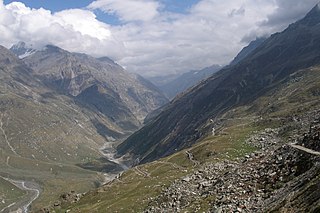
Rohtang Pass is a high mountain pass on the eastern end of the Pir Panjal Range of the Himalayas around 51 km (32 mi) from Manali in the Indian state of Himachal Pradesh. It connects the Kullu Valley with the Lahaul and Spiti Valleys of Himachal Pradesh, India.

The Pir Panjal Range is a chain of mountains in the Lower Himalayan region located in the Western Himalayas of northern Indian subcontinent. It runs southeast to northwest between the Beas and Neelam/Kishanganga rivers, in the Indian territory of Himachal Pradesh and disputed Jammu and Kashmir, with its northwestern end extending into Pakistan. The Himalayas show a gradual elevation towards the Dhauladhar and Pir Panjal ranges. Pir Panjal is the largest range of the Lesser Himalayas. Near the bank of the Sutlej River, it dissociates itself from the Himalayas and forms a divide between the Beas and Ravi rivers on one side and the Chenab on the other. Further west, the Pir Panjal range separates the Kashmir Valley from the hills of Jammu region.

Padum is the main town and the administrative centre of the Zanskar tehsil in Kargil district, Ladakh, India. Name after the Buddhist guru Padmasambhava, it was historically one of the two main capitals of the Zanskar Kingdom, the other being Zangla. It is 235 km (146 mi) via the link road from Kargil city. The new Nimmu–Padum–Darcha road connects Padum directly to Leh in the east and to Darcha in Himachal Pradesh.

Ladakh is an administrative territory of India that has been under its control since 1947. The geographical region of Ladakh union territory is the highest altitude plateau region in India, incorporating parts of the Himalayan and Karakoram mountain ranges and the upper Indus River and valley.
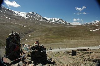
Bara-lacha la also known as Bara-lacha Pass, or Bārā Lācha La, is a high mountain pass in the Zanskar range of Northern-India, connecting Lahaul district in Himachal Pradesh to Leh district in Ladakh. Rail-cum-road tunnels are being constructed under the Bara-lacha la, at 4,750 metres (15,580 ft) high Lungalacha La and 5,184 metres (17,008 ft) high Taglang La to cater to the traffic on the existing NH3 Leh–Manali Highway and the under-construction Bhanupli–Leh line.

Tourism is one of an economic contributor to the union territory of Ladakh in Northern India. The union territory is sandwiched between the Karakoram mountain range to the north and the Himalayas to the south and is situated at the height of 11,400 ft. Ladakh is composed of the Leh and Kargil districts. The region contains prominent Buddhist sites and has an ecotourism industry.

The Zanskar River is the first major tributary of the Indus River, equal or greater in volume than the main river, which flows entirely within Ladakh, India. It originates northeast of the Great Himalayan range and drains both the Himalayas and the Zanskar Range within the region of Zanskar. It flows northeast to join the Indus River near Nimo.

Zingzingbar is a Border Roads Organization road-building camp and tea house way-station situated 25 kilometres (16 mi) from Darcha on the Manali to Leh road in the Lahaul and Spiti district of Himachal Pradesh. It is situated at an altitude of around 14,010 feet (4,270 m). The location has temporary shelters and dhabas that can be used by trekkers and tourists for accommodation.

The Leh–Manali Highway is a 428 km (266 mi) long highway in northernmost India connecting Leh, the capital of the Union Territory of Ladakh, to Manali in the state of Himachal Pradesh. It connects the Kullu Valley of the upper Beas river to the Chandra and Bhaga river valleys of Lahaul via the Atal tunnel in Himachal Pradesh, then crosses over a series of high Himalayan passes into the Indus river valley in Ladakh. It is usually open for about six months a year from the first week of May when the snow is cleared from the highway to October when snowfall again blocks the high passes on the highway. Before the construction of the Atal tunnel, the highway used to remain closed beyond the Rohtang Pass during winter. With the completion of the proposed Shingo La Tunnel on an alternate route through Zanskar valley, targeted to be completed by 2025, the whole Leh-Manali route will become an all-weather road.
Himachal Pradesh, although railways and airways serve very limited transport needs, the road network of the state serves the transport needs of the people. Although, the geography of Himachal presents considerable challenge to the development of transport infrastructure, it has the highest road density among all the Hill States of India. Himachal also has 3 airports, 2 narrow gauge rail tracks and couple of other under-construction broad gauge railway tracks, but roads remain the main mode of transport.
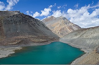
Suraj Tal, also called Tso Kamtsi or Surya Tal, is an 800 m (2,600 ft) long lake that lies just below the 4,890 m (16,040 ft) high Bara-lacha-la pass in Lahaul and Spiti district of the Indian state of Himachal Pradesh. It is the third-highest lake in India and the 21st-highest in the world. Suraj Tal Lake is just below the source of the Bhaga River that joins the Chandra River downstream at Tandi to form the Chandrabhaga River in Himachal Pradesh. The Chandrabhaga River is known as the Chenab as it enters the Jammu region of Jammu and Kashmir. The other major tributary of the Chandrabhaga, the Chandra, originates and flows south-east of the Bara-lacha La.

Kaza, also spelled Kaze, Karze, Karzey, is a town and the subdivisional headquarters of the remote Spiti Valley in the western Himalayas in the Lahaul and Spiti district of the northern Indian state of Himachal Pradesh. Spiti is a high altitude or cold desert having close similarities to the neighbouring Tibet and Ladakh regions in terms of terrain, climate and the Buddhist culture. Kaza, situated along the Spiti River at an elevation of 3,650 m (11,980 ft) above mean sea level, is the largest township and commercial center of the Spiti valley.

Karsha Monastery or Karsha Gompa is a Buddhist monastery in the Padum Valley of the Zanskar region of the union territory of Ladakh in northern India. The Doda River flows past the monastery from its source at the Drang Drung Glacier of the Pensi La. It was founded by the translator Phagspa Shesrab. The monastery, also known by the name Karsha Chamspaling, was founded by Phagspa Shesrab, under the Gelugpa Order or Yellow Hats. It is 11 km north of Padum in Zanskar River valley.

Atal Tunnel, named after former Prime Minister of India, Atal Bihari Vajpayee is a highway tunnel built under the Rohtang Pass in the eastern Pir Panjal range of the Himalayas on the National Highway 3 in Himachal Pradesh, India. At a length of 9.02 km, it is the highest highway single-tube tunnel above 10,000 feet (3,048 m) in the world. With the existing Atal Tunnel and after the completion of under-construction Shinku La Tunnel, which is targeted to be completed by 2025, the new Leh-Manali Highway via Nimmu–Padum–Darcha road will become all-weather road.

Darcha is a pair of villages on the Bhaga River in the Lahaul sub-division in the Lahaul and Spiti district in the Indian state of Himachal Pradesh. It is the northernmost permanent settlement in Himachal Pradesh along the Manali-Leh Highway. With the opening of the Atal Tunnel, Darcha is likely to see a large influx of tourists as it is now connected to Manali throughout the year. The Nimmu–Padam–Darcha road which is being constructed, will improve connectivity of Kargil, Zanskar and Leh District of Ladakh to Darcha.

National Highway 3, or NH 3, is a national highway in India. It starts from Atari adjacent to India-Pakistan border and near Amritsar and terminates at Leh in Ladakh, via Manali in Himachal Pradesh.
Chiling Sumda is a village in the Leh district of Ladakh, India. It is located Nimmu–Padum–Darcha road (NPDR) or Zanskar Highway in the Likir tehsil, on the bank of the Zanskar River in Zanskar region. It serves as a base camp for the Chadar Trek in the winters and is used to raft the Zanskar river in the summers.

Nimmu–Padum–Darcha road (NPDR) or Zanskar Highway is a road under construction between the Indian union territory of Ladakh and the state of Himachal Pradesh, passing through the region of Zanskar. It connects Nimmu in the Indus Valley to Padum, the capital of Zanskar, to Darcha village in Lahul and Spiti. It provides an alternative to the Leh–Manali Highway in linking Ladakh with the rest of India. It is being built by the Border Roads Organisation (BRO) of the Indian army. Construction of road is expected to be completed by late 2023. The already completed Atal tunnel and the proposed unidirectional-twin-tube total-4-lane Shingo La Tunnel which is expected to be completed by 2025 will provide all weather connectivity and reduce the Manali to Kargil distance by 522 km.
Tsultrim Chonjor also known as Chultim Chonjor is an Indian social worker from stongde village in Ladakh. The Government of India honoured Wadia in 2021, with the award of Padma Shri, the fourth highest Indian civilian award for his social work.


