
Ladakh is a region administered by India as a union territory which constitutes a part of the larger Kashmir region and has been the subject of dispute between India, Pakistan, and China since 1947. Ladakh is bordered by the Tibet Autonomous Region to the east, the Indian state of Himachal Pradesh to the south, both the Indian-administered union territory of Jammu and Kashmir and the Pakistan-administered Gilgit-Baltistan to the west, and the southwest corner of Xinjiang across the Karakoram Pass in the far north. It extends from the Siachen Glacier in the Karakoram range to the north to the main Great Himalayas to the south. The eastern end, consisting of the uninhabited Aksai Chin plains, is claimed by the Indian Government as part of Ladakh, and has been under Chinese control since 1962.

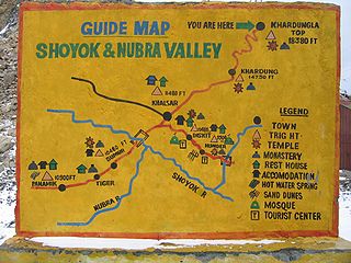
Nubra, also called Dumra, is a historical region of Ladakh, India that is currently administered as a subdivision and a tehsil in the Leh district. Its inhabited areas form a tri-armed valley cut by the Nubra and Shyok rivers. Its Tibetan name Dumra means "valley of flowers". Demands have been raised and BJP has hinted at creation of Nubra as a new district. Diskit, the headquarters of Nubra, is 120 km north of Leh, the capital of Ladakh.
Khardung La or Khardung Pass is a mountain pass in the Leh district of the Indian union territory of Ladakh.
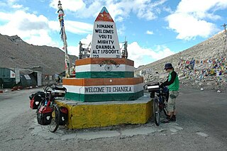
Chang La is a high mountain pass in Ladakh at an elevation of 5,391.3024 m or 17,688.000 ft in the Ladakh Range between Leh and the Shyok River valley. The Chang La, on Leh to Pangong Lake road, lies on the Leh-Karu-Sakti-Zingral-Chang La-Durbuk-Tangtse-Pangong Lake motorable road. Karu, which lies on Leh-Manali NH-3, connects Chang La and Pangong Lake to Leh and the rest of India. In September 2021, BRO opened another alternate motorable asphalt road between Zingral and Tangtse via Ke La pass and Taruk.
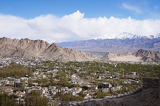
Leh district is a district in the union territory of Ladakh, India. With an area of 45,110 km2, it is the second largest district in the country, second only to Kutch. It is bounded on the north by Gilgit-Baltistan's Kharmang and Ghanche districts and Xinjiang's Kashgar Prefecture and Hotan Prefecture, to which it connects via the historic Karakoram Pass. Aksai Chin and Tibet are to the east, Kargil district to the west, and Lahul and Spiti to the south. The district headquarters is in Leh. It lies between 32 to 36 degree north latitude and 75 to 80 degree east longitude.

Shingo-La is a mountain pass in India, on the border between Ladakh and Himachal Pradesh.

Tourism is one of an economic contributor to the union territory of Ladakh in Northern India. The union territory is sandwiched between the Karakoram mountain range to the north and the Himalayas to the south and is situated at the height of 11,400 ft. Ladakh is composed of the Leh and Kargil districts. The region contains prominent Buddhist sites and has an ecotourism industry.
Tegar, also known as Kyagar, is a high-altitude village in the Leh district of Ladakh, India. It is located in the Nubra tehsil, in the Nubra Valley.

Thoise or Thoise Airbase is a military airfield and small village in Nubra region of Ladakh, India, occupying the only large piece of flat land in the area. The airstrip is a critical facility enabling a quick inflow of men and material from the Indian interior to Siachen, a glacier, helipad and battleground near the Actual Ground Position Line between India and Pakistan.
Himank, also styled Project HIMANK, is a project of the Border Roads Organisation (BRO) in the Ladakh region of northernmost India that started in August 1985. It is known for constructing some of world's highest motorable roads across the Khardung La, Tanglang La and Chang La passes. Umling la is the highest motorable road on Earth with height 5882 metres. It is responsible for constructing and maintaining motorable roads in Ladakh, along the Line of Actual Control. Himank project ensures access to sensitive military areas including the world's highest battleground at the Siachen Glacier and Pangong Tso Lake, whose waters span the de facto India-China border. Nicknamed "The Mountain Tamers", much of Himank's work is constrained to four months per year, as heavy snow and extreme cold make some roads inaccessible at other times. Between 1987 and 2002, at least 124 Himank personnel were killed while on duty in Ladakh, including five officers. Most of its manual labourers are from Bihar state, not Ladakh. They are nicknamed Dumkas, where many of the original Himank workers were recruited.

Diskit Monastery also known as Deskit Gompa or Diskit Gompa is the oldest and largest Buddhist monastery (gompa) in Diskit, Nubra Valley of the Leh district of Ladakh.

National Highway 1 in India runs between the union territories of Jammu & Kashmir and Ladakh. It comprises parts of old NH1A and NH1D. The number 1 indicates, under the new numbering system, that it is the northernmost East-West highway in India.
Demchok , previously called New Demchok, and called Parigas by the Chinese, is a village and military encampment in the Indian-administered Demchok sector that is disputed between India and China. It is administered as part of the Nyoma tehsil in the Leh district of Ladakh by India, and claimed by China as part of the Tibet Autonomous Region.
Durbuk or Darbuk, is a village and the headquarters of the eponymous subdivision and block in the Leh district of Ladakh, India. It is located in the Durbuk tehsil, and falls between Chang La mountain pass and Tangste village on the way to Pangong Tso Lake.
Khalsar is a village in the Leh district of Ladakh, India. It is located in the Nubra tehsil.
The Darbuk–Shyok–DBO Road, also called the Sub-Sector North Road, is a strategic all-weather road in eastern Ladakh in India, close to the Line of Actual Control with China. It connects Ladakh's capital city Leh, via the villages of Darbuk and Shyok at southern Shyok River Valley, with the Daulat Beg Oldi (DBO) post near the northern border. The 220-km long section between Shyok and DBO was constructed between 2000 and 2019 by India's Border Roads Organisation (BRO). The DS-DBO Road has reduced the travel time between Leh to DBO from 2 days to 6 hours. In January 2023, BRO announced that it is constructing the DSDBO tunnel on this route.
The Sasoma–Sasser La-Saser Brangsa-Gapsam-Daulat Beg Oldi Road, also Sasoma-Sasser La Road or the Sasoma–Saser Pass Road, is an under-construction road in Ladakh in India between Nubra Valley and Daulat Beg Oldi (DBO) in Depsang Plains. This also includes construction of a tunnel between Saser La 17,800 feet (5,400 m) to Saser Brangsa, wildlife approval for which was already granted in April 2022. As of January 2023, Sasoma in south to Saser La in north route is under-construction - which is reachable on Saser La side from Murgo in northeast by a motorable road, Saser La to Saser Brangsa in northwest is a 30 km foot track under which a highway tunnel will be built, Saser Brangsa-Gapsam-Daulat Beg Oldi section in northwest is already motorable. SSSG-DBO Road connects to Darbuk–Shyok–DBO Road at two places: at Daulat Beg Oldi in northwest and also via the Saser La to Murgo spur in northeast. Border Roads Organisation is constructing this road under the Project Himank. This strategically important road provides a much shorter alternative access from Nubra Valley to DBO as compared to the longer 230 km route via DS-DBO Road.
India–China Border Roads is a Government of India project for developing infrastructure along the Sino-Indian border by constructing strategic roads, including bridges and tunnels. The ICBR project is largely in response to Chinese infrastructure development along the borderlands with India.

Nimmu–Padum–Darcha road or Zanskar Highway is a road under construction between the Indian union territory of Ladakh and the state of Himachal Pradesh, passing through the region of Zanskar. It connects Nimmu in the Indus Valley to Padum, the capital of Zanskar, to Darcha village in Lahul and Spiti. It provides an alternative to the Leh–Manali Highway in linking Ladakh with the rest of India. It is being built by the Border Roads Organisation (BRO) of the Indian army. Construction of road is expected to be completed by late 2023. Already completed Atal tunnel and the under-construction Shingo La Tunnel which will be completed by 2025 will provide all weather connectivity.
Shyok or Shayok is a village on the bank of the Shyok River in Durbuk tehsil of Leh district in Ladakh, India. It is located at the southern tip of the V-shaped course of the Shyok River, where the Tangtse river joins it from the left. Historically, the winter caravan route from Leh to Yarkand passed through the village. In modern times, India's strategic road to its border post at Daulat Beg Oldi uses the same route.

