
Nubra, also called Dumra, is a historical region of Ladakh, that is currently administered as a subdivision and a tehsil in the Leh district. Its inhabited areas form a tri-armed valley cut by the Nubra and Shyok rivers. Its Tibetan name Dumra means a "valley of flowers". Demands have been raised and BJP has hinted at creation of Nubra as a new district. Diskit, the headquarters of Nubra, is 120 km north from Leh, the capital of Ladakh.
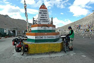
Chang La is a high mountain pass in Ladakh at an elevation of 5,391.3024 m or 17,688.000 ft in the Ladakh Range between Leh and the Shyok River valley.
Leh district is a district in the union territory of Ladakh, a territory administered as part of India. With an area of 45,110 km2, it is the second largest district in the country smaller only to Kutch. It is bounded on the north by Gilgit-Baltistan's Kharmang and Ghanche districts and Xinjiang's Kashgar Prefecture and Hotan Prefecture linked via the historic Karakoram Pass. It has Aksai Chin and Tibet are to the east, Kargil district to the west, and Lahul and Spiti to the south. The district headquarters is in Leh. It lies between 32 to 36 degree north latitude and 75 to 80 degree east longitude.

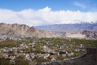
The Ladakh Range is a mountain range in central Ladakh in the Indian Union territory of Ladakh with its northern tip extending into Ladakh in India. It lies between the Indus and Shyok river valleys, stretching to 230 miles (370 km). Leh, the capital city of Ladakh, is on the foot of Ladakh Range in the Indus river valley.

Tourism is one of an economic contributor to the union territory of Ladakh in Northern India. The union territory is sandwiched between the Karakoram mountain range to the north and the Himalayas to the south and is situated at the height of 11,400 ft. Ladakh is composed of the Leh and Kargil districts. The region contains prominent Buddhist sites and has an ecotourism industry.

The Shyok River a tributary of the Indus River that flows through northern Ladakh and enters Gilgit–Baltistan, spanning some 550 km (340 mi).

Daulat Beg Oldi is a traditional campsite and current military base located in the midst of the Karakoram Range in northern Ladakh, India. It is on the historic trade route between Ladakh and Central Asia, forming the last campsite before reaching the Karakoram Pass. It is said to be named after Sultan Said Khan, who died here on his return journey after an invasion of Ladakh and Kashmir. Chip Chap River, the main headwater of the Shyok River, flows just to the south. The Line of Actual Control with Chinese-controlled Aksai Chin is 5 miles to the east.

Marsimik La or Marsemik La, also called Lankar La, elevation 5,582 metres (18,314 ft) is a high mountain pass in the Chang Chenmo Range in the Indian union territory of Ladakh, 96 km (60 mi) east of Leh as the crow flies. Ladakh's route to the Chang Chenmo Valley traverses the pass.

The Depsang Plains represent a high-altitude gravelly plain at the northwest portion of the disputed Aksai Chin region of Kashmir, divided into Indian and Chinese administered portions across a Line of Actual Control. India controls the western portion of the plains as part of Ladakh, whereas the eastern portion is controlled by China and claimed by India. The Line of Control with Pakistan-administered Gilgit-Baltistan is 80 kilometres (50 mi) west of the Depsang Plains with the Siachen Glacier in-between. Ladakh's traditional trade route to Central Asia passed through the Depsang Plains, with the Karakoram Pass lying directly to its north.
Chushul is a village in the Leh district of Ladakh, India. It is located in the Durbuk tehsil, in the area known as "Chushul Valley", south of the Pangong Lake and west of the Spanggur Lake. The Line of Actual Control with China runs about 5 miles east of Chushul, across the Chushul Valley. Famous as site for historical battle grounds.

The Galwan River flows from the disputed Aksai Chin region administered by China to the Ladakh region of India. It originates near the caravan campsite Samzungling on the eastern side of the Karakoram range and flows west to join the Shyok River. The point of confluence is 102 km south of Daulat Beg Oldi. Shyok River itself is a tributary of the Indus River, making Galwan a part of the Indus River system.
The Chip Chap River is a tributary of the Shyok River that flows from the disputed Aksai Chin region administered by China to Ladakh in India. It originates at the eastern edge of the Depsang Plains and flows west, skirting around the Depsang Plains in the north. It discharges into the Shyok River, forming one of the upstream tributaries of the Indus River.
Murgo is a small hilly village which lies on the border of Leh district in the union territory of Ladakh in India, close to Chinese-controlled Aksai Chin. It is one of the northernmost villages of India.
Tangtse (Tanktse or Tankse) is a village in the Leh district of Ladakh, India. It is located in the Durbuk tehsil. Traditionally, it was regarded as the border between the Nubra region to the north and the Pangong region to the south. It was a site of wars between Ladakh and Tibet.
Durbuk or Darbuk, is a village and the headquarters of the eponymous subdivision and block in the Leh district of Ladakh, India. It is located in the Durbuk tehsil, and falls between Chang La mountain pass and Tangste village on the way to Pangong Tso Lake.

Air Vice Marshal Suryakant Chintaman Chafekar AVSM, Shaurya Chakra is a retired Indian Air Force (IAF) officer who served as the Senior Air and Administration Staff Officer, Maintenance Command, IAF, from 1 July 2016 until he retired on 30 September 2017. He was the commanding officer of No. 48 Squadron IAF. During his career he landed Antonov An-32 aircraft on High Altitude Advanced Landing Grounds (HAALG)s in Daulat Beg Oldi, Fukche and Nyoma.

Chang Chenmo River or Changchenmo River is a tributary of the Shyok River, part of the Indus River system. It is at the southern edge of the disputed Aksai Chin region and north of the Pangong Lake basin.
The Darbuk–Shyok–DBO Road, also called the Sub-Sector North Road, is a strategic all-weather road in eastern Ladakh in India, close to the Line of Actual Control with China. It connects Ladakh's capital city Leh, via the villages of Darbuk and Shyok at southern Shyok River Valley, with the Daulat Beg Oldi (DBO) post near the northern border. The 220-km long section between Shyok and DBO was constructed between 2000 and 2019 by India's Border Roads Organisation (BRO). The DS-DBO Road has reduced the travel time between Leh to DBO from 2 days to 6 hours.
The Sasoma–Sasser La Road or the Sasoma–Saser Pass Road is a road reportedly being built in Ladakh between Nubra and Daulat Beg Oldi (DBO). Being constructed at a height of 17,800 feet (5,400 m) by the Border Roads Organisation under Project Himank, despite the glaciated mountain tops that it has to pass through. It is expected to provide an alternative access to DBO, other than the Darbuk–Shyok–DBO Road. It is considered to be of strategic importance.
The Depsang Bulge or Burtsa Bulge is a 900 square kilometre area of mountain terrain in the disputed Aksai Chin region, which was conceded to India by China in 1960 but remains under Chinese occupation since the 1962 Sino-Indian War. The area is immediately to the south of Depsang Plains and encloses the basin of the Raki Nala, a stream originating in the Aksai Chin region and flowing west to merge with the Depsang Nala near the village of Burtsa in Ladakh, eventually draining into the Shyok River. The area is perceived to be of strategic importance to both the countries, sandwiched by strategic roads linking border outposts. Since 2013, China has made attempts to push the Line of Actual Control further west into the Indian territory, threatening India's strategic road.


