
Ladakh is an administrative territory of India that has been under its control since 1947. The geographical region of Ladakh union territory is the highest altitude plateau region in India, incorporating parts of the Himalayan and Karakoram mountain ranges and the upper Indus River and valley.
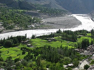
The Suru River is a tributary of the Indus River that flows largely through the Kargil district of Ladakh, India. The Suru Valley is coextensive with the Kargil tehsil, with the town of Kargil situated on its banks. The river enters the Kharmang District of Pakistani-administered Gilgit-Baltistan, coursing a brief length before joining the Indus near Marol.

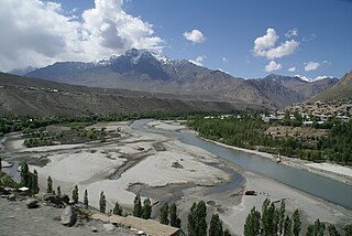
The Dras River, also spelt Drass River, is a river in the Kargil district in the Indian union territory of Ladakh. It originates below the Zoji La pas in the Great Himalayan range and flows northeast towards Kargil, where it joins the Suru River. The Shingo River, which flows in a parallel direction in Pakistan-administered Baltistan, also joins the Drass River. The combined river is alternatively called Suru, Drass and Shingo by various local groups.

The Ladakh Range is a mountain range in central Ladakh in India with its northern tip extending into Baltistan in Pakistan. It lies between the Indus and Shyok river valleys, stretching to 230 miles (370 km). Leh, the capital city of Ladakh, is on the foot of Ladakh Range in the Indus river valley.
Rupshu is a high elevation plateau and valley and an eponymous community development block in southeast Ladakh. It is between the Startsapuk Tso and Tso Moriri, and west of Mahe.

The Brokpa, sometimes referred to as Minaro, are a small ethnic group mostly found in the union territory of Ladakh, India around the villages of Dha and Hanu. Some of the community are also located across the Line of Control in Baltistan in the villages around Ganokh. They speak an Indo-Aryan language called Brokskat. The Brokpa are mostly Vajrayana Buddhist while some are Muslim.
Chushul is a village in the Leh district of Ladakh, India. It is located in the Durbuk tehsil, in the area known as "Chushul Valley", south of the Pangong Lake and west of the Spanggur Lake. The Line of Actual Control with China runs about 5 miles east of Chushul, across the Chushul Valley. Famous as site for historical battle grounds.
Nyoma is a principal village of southern Ladakh in India, the headquarters of an eponymous subdivision, tehsil, community development block and Indian Air Force Base in the Leh district. It is located on the bank of the Indus river after its 90-degree bend near Dungti east of Nyoma and before the valley narrows to a gorge near Mahe northwest of Nyoma. The Nyoma tehsil and subdivision cover all of southern Ladakh, including the Rupshu plains south of Nyoma, the Indus valley of Skakjung north of Nyoma, and the Hanle valley. Nyoma gompa, a Buddhist monastery, is located on the hill slope north of the village.
NJ9842, also called NJ 980420, is the northernmost demarcated point of the India-Pakistan cease fire line in Kashmir known as the Line of Control (LoC). The India–Pakistan AGPL, begins from the NJ9842 on LoC and ends near the Indira Ridge at the trijunction of areas controlled by China, India, and Pakistan.

Chorbat Valley is a section of the Shyok river valley divided between Pakistan-administered Gilgit-Baltistan and Indian-administered Ladakh. The Pakistan-administered portion is in the Khaplu tehsil of Ghanche District in Gilgit–Baltistan, and the Indian-administered portion is in the Nubra tehsil, Leh district of Ladakh. Chorbat stretches from the edge of Khaplu to the Chalunka village of Nubra.
Tangtse or Drangtse (Tibetan: བྲང་རྩེ, Wylie: brang rtse, THL: drang tsé) is a village in the Leh district of Ladakh, India. It is located in the Durbuk tehsil. Traditionally, it was regarded as the border between the Nubra region to the north and the Pangong region to the south. It was a key halting place on the trade route between Turkestan and Tibet. It was also a site of wars between Ladakh and Tibet.
Dah is a panchayat village in the Leh district of Ladakh, India. It is the most prominent of all the Brokpa settlements, other than Dah, it has six hamlets: Biama(or phunder), Baldes, Sannit, Pardos, Lastyang and Dundur It is located east of Batalik in Aryan Valley of Indus river of Ladakh in the Khalsi tehsil.
Durbuk or Darbuk, is a village and the headquarters of the eponymous subdivision and block in the Leh district of Ladakh, India. It is located in the Durbuk tehsil, and falls between Chang La mountain pass and Tangste village on the way to Pangong Tso Lake.
Koyul is a village in the Leh district of Ladakh, India. It is located in the Nyoma tehsil, on the banks of the Koyul Lungpa river just before it joins the Indus River.
Garkon is a panchayat village in the Aryan valley region located in the Kargil block of Kargil district, in a rural region of the Indian union territory of Ladakh. It is located east of Batalik in Aryan Valley of Indus river system.
Siksa is a village in the sub division Chorbat Valley, Ghanche District of Gilgit-Baltistan, lying 150 kilometres (93 mi) east of Skardu, near the border of Pakistan and India at an elevation of 2,725 metres (8,940 ft).

Chang Chenmo River or Changchenmo River is a tributary of the Shyok River, part of the Indus River system. It is at the southern edge of the disputed Aksai Chin region and north of the Pangong Lake basin.
Dumchele or Dhumtsele (Chinese: 都木契列; pinyin: Dōu mù qì liè, Tibetan: སྡུམ་མཚེས་ལེ་, Wylie: sdum mtshes le, THL: dum tsé lé) is a village and a grazing area in Skakjung pasture near the Line of Actual Control between Ladakh and Tibet, administered by China since October 1962 but claimed by India. The locale is in the disputed Demchok sector, about 50 kilometers northwest from Demchok and 50 kilometers southeast of Chushul. It lies on a historic trade route between Ladakh and Rutog, with an erstwhile border pass at Chang La or Shingong La to the southeast of Dumchele.

Aryan Valley, historically known as Dah Hanu region, is an area comprising four village clusters — Dah and Hanu in Leh district, and Garkon and Darchik in Kargil district — in Central Ladakh in India. It is inhabited by Brokpa people of Dardic origin. Until its absorption into the Maryul kingdom, Brokpa chiefs wielded nominal autonomy in the region.
Ganokh, locally called Ganishah, is a village in the Kharmang District of Baltistan, Pakistan, close to the Line of Control with Indian-administered Ladakh. It is populated by Brokpas professing Shia Islam.
