Kanji, Ladakh

Last updated

Kanji
village
Kanjivillage.jpg
Coordinates: 34°15′N76°36′E / 34.25°N 76.6°E / 34.25; 76.6 Coordinates: 34°15′N76°36′E / 34.25°N 76.6°E / 34.25; 76.6
Country India
State Jammu and Kashmir
District Leh
Tehsil Khalsi
Elevation
3,875 m (12,713 ft)
Population
 (2011)
  Total325
Time zone UTC+5:30 (IST)
2011 census code958
Primary school, Kanji Kanjischool.jpg
Primary school, Kanji

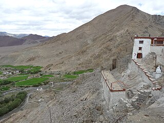
Kanji is a village in the Leh district of Union Territory Ladakh of India. [1] It is located in the Khalsi tehsil, and can be accessed through the village of Heniskot which lies on the Srinagar-Kargil-Leh highway.

Leh district is a district in the Ladakh region of northern India. With an area of 45,110 km2, it is the second largest district in the country in terms of area. It is bounded on the north by Gilgit-Baltistan's Kharmang and Ghanche districts and Xinjiang's Kashgar and Hotan prefectures linked via the historic Karakoram Pass. It has Aksai Chin and Tibet are to the east, Kargil district to the west, and Lahul and Spiti to the south. The district headquarters is in Leh. It lies between 32 to 36 degree north latitude and 75 to 80 degree east longitude.

A union territory is a type of administrative division in the Republic of India. Unlike the states of India, which have their own governments, union territories are usually federal territories governed directly by the central Government of India.

Ladakh Union territory of India

Ladakh is a region administered by India as a union territory, and constituting a part of the larger region of Kashmir, which has been the subject of dispute between India, Pakistan, and China since 1947. It is bordered by Tibet to the east, the Indian state of Himachal Pradesh to the south, Jammu and Kashmir and Baltistan to the west, and the southwest corner of Xinjiang across the Karakoram Pass in the far north. It extends from the Siachen Glacier in the Karakoram range to the north to the main Great Himalayas to the south. The eastern end of Ladakh, consisting of the uninhabited Aksai Chin plains, has been under Chinese control since 1962.

The village has a small number of families who farm the immediate area. The village is situated on an altitude of 3875 m, and is a campsite on the Kanji la and Shilakong gorge treks.

Demographics

According to the 2011 census of India, Kanji has 52 households. The effective literacy rate (i.e. the literacy rate of population excluding children aged 6 and below) is 62.19%. [2]

Demographics (2011 Census) [2]
TotalMaleFemale
Population325165160
Children aged below 6 years422022
Scheduled caste 000
Scheduled tribe 324165159
Literates1769482
Workers (all)1397465
Main workers (total)1387464
Main workers: Cultivators653728
Main workers: Agricultural labourers716
Main workers: Household industry workers563026
Main workers: Other1064
Marginal workers (total)101
Marginal workers: Cultivators000
Marginal workers: Agricultural labourers000
Marginal workers: Household industry workers000
Marginal workers: Others101
Non-workers1869195

Related Research Articles

Chushul village in Ladakh, India

Chushul is a village in the Leh district of Ladakh, India. It is located in the Leh tehsil, in the area known as "Chushul Valley".

Nyoma village in Ladakh, India

Nyoma is a village and headquarter of eponymous Subdivision and block in the Leh district of Ladakh in India. It is located in the Leh tehsil, on the bank of Indus River.

Tarchit village in Jammu and Kashmir, India

Tarchit is a village in the Leh district of Jammu and Kashmir, India. It is located in the Leh tehsil.

Phuktse is a village in the Leh district of Jammu and Kashmir, India. It is located in the Leh tehsil.

Taroo village in Jammu and Kashmir, India

Taroo is a village in the Leh district of Jammu and Kashmir, India. It is located in the Leh tehsil.

Kumgyam village in Jammu and Kashmir, India

Kumgyam is a village in the Leh district of Jammu and Kashmir, India. It is located in the Leh tehsil.

Durbok village in Ladakh, India

Durbok, also spelled Durbuk, is a village and headquarter of eponymous Subdivision and block in the Leh district of Ladakh, India. It is located in the Leh tehsil.

Gia, Leh village in Ladakh, India

Gia or Gya is a village in the Leh district of Ladakh in India. It is located in the Leh tehsil, off the Leh–Manali Highway, close to Tso Kar.

Umla village in Jammu and Kashmir, India

Umla is a village in the Leh district of Jammu and Kashmir, India. It is located in the Leh tehsil.

Mood, Leh village in Jammu and Kashmir, India

Mood is a village in the Leh district of Jammu and Kashmir, India. It is located in the Leh tehsil.

Meroo, Leh village in Jammu and Kashmir, India

Meroo is a village in the Leh district of Jammu and Kashmir, India. It is located in the Leh tehsil.

Kerey village in Jammu and Kashmir, India

Kerey is a village in the Leh district of Jammu and Kashmir, India. It is located in the Leh tehsil.

Samad Rakchan village in Jammu and Kashmir, India

Samad Rakchan is a village in the Leh district of Jammu and Kashmir, India. It is located in the Leh tehsil.

Sakti, Leh village in Jammu and Kashmir, India

Sakti is a village in the Leh district of Jammu and Kashmir, India. It is located in the Leh tehsil. The Takthok Monastery is located here.

Takshi village in Ladakh, India

Takshi is a village in the Leh district of Ladakh, India. It is in the historical Chorbat region of Baltistan, divided between India and Pakistan by the 1972 Line of Control. Takshi is part of the Nubra tehsil and the Turtuk community development block.

Suspol, also spelled Saspol, is a village and eponymous tehsil headquarter in the Leh district of Ladakh in India.

Skitmang is a village in the Leh district of Jammu and Kashmir, India. It is located in the Leh tehsil.

Langokor is a village in the Leh district of Jammu and Kashmir, India. It is located in the Leh tehsil.

Phey village in Jammu and Kashmir, India

Phey is a village in the Leh district of Jammu and Kashmir, India. It is located in the Leh tehsil.

Panamic village in Ladakh, India

Panamic is a village in the Leh district of Ladakh in India. It is located in the Nubra tehsil.

References

  1. "Blockwise Village Amenity Directory" (PDF). Ladakh Autonomous Hill Development Council. Retrieved 23 July 2015.
  2. 1 2 "Leh district census". 2011 Census of India . Directorate of Census Operations. Retrieved 23 July 2015.