Ladakh is a region administered by India as a union territory and constitutes an eastern portion of the larger Kashmir region that has been the subject of a dispute between India and Pakistan since 1947 and India and China since 1959. Ladakh is bordered by the Tibet Autonomous Region to the east, the Indian state of Himachal Pradesh to the south, both the Indian-administered union territory of Jammu and Kashmir and the Pakistan-administered Gilgit-Baltistan to the west, and the southwest corner of Xinjiang across the Karakoram Pass in the far north. It extends from the Siachen Glacier in the Karakoram range to the north to the main Great Himalayas to the south. The eastern end, consisting of the uninhabited Aksai Chin plains, is claimed by the Indian Government as part of Ladakh, but has been under Chinese control.

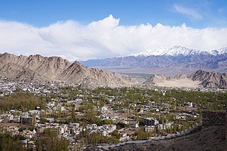
Leh is a city in Ladakh in the Kashmir region. It is the largest city and the joint capital of Ladakh. Leh, located in the Leh district, was also the historical capital of the Kingdom of Ladakh. The seat of the kingdom, Leh Palace, the former residence of the royal family of Ladakh, was built in the same style and about the same time as the Potala Palace in Tibet. Since they were both constructed in a similar style and at roughly the same time, the Potala Palace in Tibet and Leh Palace, the royal residence, are frequently contrasted. Leh is at an altitude of 3,524 m (11,562 ft), and is connected via National Highway 1 to Srinagar in the southwest and to Manali in the south via the Leh-Manali Highway.

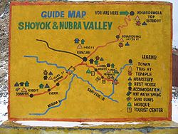
Nubra, also called Dumra, is a historical region of Ladakh, India that is currently administered as a subdivision and a tehsil in the Leh district. Its inhabited areas form a tri-armed valley cut by the Nubra and Shyok rivers. Its Tibetan name Dumra means "valley of flowers". Demands have been raised and BJP has hinted at creation of Nubra as a new district. Diskit, the headquarters of Nubra, is 120 km north of Leh, the capital of Ladakh.
Leh district is a district in Indian-administered Ladakh in the disputed Kashmir-region. Ladakh is an Indian-administered union territory. With an area of 45,110 km2, it is the second largest district in the country, second only to Kutch. It is bounded on the north by Gilgit-Baltistan's Kharmang and Ghanche districts and Xinjiang's Kashgar Prefecture and Hotan Prefecture, to which it connects via the historic Karakoram Pass. Aksai Chin and Tibet are to the east, Kargil district to the west, and Lahul and Spiti to the south. The district headquarters is in Leh. It lies between 32 and 36 degree north latitude and 75 to 80 degree east longitude.

Ladakh has a long history with evidence of human settlement from as back as 9000 b.c. It has been a crossroad of high Asia for thousands of years and has seen many cultures, empires and technologies born in its neighbours. As a result of these developments Ladakh has imported many traditions and culture from its neighbours and combining them all gave rise to a unique tradition and culture of its own.

Ladakh is an administrative territory of India that has been under its control since 1947. The geographical region of Ladakh union territory is the highest altitude plateau region in India, incorporating parts of the Himalayan and Karakoram mountain ranges and the upper Indus River and valley.

Tourism is one of the economic contributors to the union territory of Ladakh in Northern India. The union territory is sandwiched between the Karakoram mountain range to the north and the Himalayas to the south, and is situated at a height of 11,400 ft. Ladakh is composed of Leh and Kargil districts. The region contains prominent Buddhist sites and has an ecotourism industry.

The Shyok River is a tributary of the Indus River that flows through northern Ladakh and enters Gilgit–Baltistan, in Pakistan, spanning some 550 km (340 mi).

Thiksey Monastery or Thiksey Gompa is a Buddhist monastery affiliated with the Gelug school of Tibetan Buddhism. It is located on top of a hill in Thiksey approximately 19 kilometres (12 mi) east of Leh, in the Ladakh region of northern India. It is noted for its resemblance to the Potala Palace in Lhasa, Tibet, and is the largest monastery in central Ladakh, notably containing a separate set of buildings for female renunciates that has been the source of significant recent building and reorganization.

Diskit is a village and headquarter of the Nubra tehsil and the Nubra subdivision in the Leh district of Ladakh, India. The Diskit Monastery is located in this village.

Likir Monastery or Likir Gompa (Klud-kyil) is a Buddhist monastery in Ladakh, Northern India. It is located at 3700m elevation, approximately 52 kilometres (32 mi) west of Leh. It is picturesquely situated on a little hill in the valley, in Likir village near the Indus River about 9.5 kilometres (5.9 mi) north of the Srinigar to Leh highway. It belongs to the Gelugpa sect of Tibetan Buddhism and was established in 1065 by Lama Duwang Chosje, at the command of the fifth king of Ladakh, Lhachen Gyalpo (Lha-chen-rgyal-po). It is off the Leh-Kargil Highway, 50 km west of Leh between Alchi & Basgo, 17 km west of Basgo Monastery & 21 km northeast of Alchi Monastery.

Diskit Monastery also known as Deskit Gompa or Diskit Gompa is the oldest and largest Buddhist monastery (gompa) in Diskit, Nubra Valley of the Leh district of Ladakh. It is 115 km north of Leh.

Sankar Monastery, or Sankar Gompa is a Buddhist monastery within an easy half-hour walk from Leh in Ladakh, northern India. It is a daughter-establishment of the Spituk Monastery and the residence of the Abbot of Spituk, the Venerable Kushok Bakula, who is the senior incarnate lama of Ladakh due to his ancient lineage and personal authority.

Chorbat Valley is a section of the Shyok river valley divided between Pakistan-administered Gilgit-Baltistan and Indian-administered Ladakh. The Pakistan-administered portion is in the Khaplu tehsil of Ghanche District in Gilgit–Baltistan, and the Indian-administered portion is in the Nubra tehsil, Leh district of Ladakh. Chorbat stretches from the edge of Khaplu to the Chalunka village of Nubra.
All Ladakh Gonpa Association (ALGA) is the central organisation of the Buddhist monasteries in Ladakh, India. It aims to preserve and strengthen the monastic institutions. It was founded by the 19th Kushok Bakula Rinpoche in 1949 and he acted as its president for 41 years, from 1949 until 1991. In 1949, the first meeting of the great monasteries was held and ten monasteries took part. All Ladakh Gonpa Association was registered in 1959 and is run by a governing body consisting of fifteen lama members belonging to all four major schools of Tibetan Buddhism. There are sixteen major monastic institutions with hundreds of monks in each monastery.

Demchok , previously called New Demchok, and called Parigas by the Chinese, is a village and military encampment in the Indian-administered Demchok sector, that is disputed between India and China. It is administered as part of the Nyoma tehsil in the Leh district of Ladakh by India, and claimed by China as part of the Tibet Autonomous Region.
Tangtse or Drangtse (Tibetan: བྲང་རྩེ, Wylie: brang rtse, THL: drang tsé) is a village in the Leh district of Ladakh, India. It is located in the Durbuk tehsil. Traditionally, it was regarded as the border between the Nubra region to the north and the Pangong region to the south. It was a key halting place on the trade route between Turkestan and Tibet. It was also a site of wars between Ladakh and Tibet.
Durbuk or Darbuk, is a village and the headquarters of the eponymous subdivision and block in the Leh district of Ladakh, India. It is located in the Durbuk tehsil, and falls between Chang La mountain pass and Tangste village on the way to Pangong Tso Lake.

Hundar is a village in the Leh district of Ladakh, India, famous for sand dunes and Bactrian camels. It is located in the Nubra tehsil, on the banks of the Shyok River. The Hunder Monastery is located here.

The culture of Ladakh refers to the traditional customs, belief systems, and political systems that are followed by Ladakhi people in India. The languages, religions, dance, music, architecture, food, and customs of the Ladakh region are similar to neighboring Tibet. Ladakhi is the traditional language of Ladakh. The popular dances in Ladakh include the khatok chenmo, cham, etc. The people of Ladakh also celebrate several festivals throughout the year, some of the most famous are Hemis Tsechu and Losar.