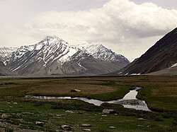
Suru Valley

Last updated

Suru Valley Galloping horses.jpg
Suru Valley
The upper Suru Valley near Rangdum. Rangdum.jpg
The upper Suru Valley near Rangdum.
The landscape of the lower Suru Valley, looking south towards Nun Kun. As viewed from between Sanku and Panikhar. Lower Suru Valley landscape near Purtikchay between Sanku and Panikhar.JPG
The landscape of the lower Suru Valley, looking south towards Nun Kun. As viewed from between Sanku and Panikhar.

The Suru Valley is a valley in the Kargil District in the Union Territory of Ladakh, India. It is drained by the Suru River, a tributary of the Indus River. The valley's most significant town is Sankoo.

Contents

Horses, yaks and other animals can be found in the valley. In winter Suru Valley experiences heavy snowfall and avalanches. The literacy rate of Suru Valley is very low as compared to other parts of Ladakh.

History

Giant Maitreya rock carving at Karpokhar near Kartse Rock carving karpokhar suru valley.jpg
Giant Maitreya rock carving at Karpokhar near Kartse
Sketch of the Maitreya carving by Frederic Drew Kartse-Maitreya-Drew.png
Sketch of the Maitreya carving by Frederic Drew

The Suru Valley was historically ruled from Kartse (Wylie : dkar rtse, 34°16′02″N76°00′06″E / 34.2672°N 76.0018°E / 34.2672; 76.0018 (Kartse Khar) ), a fort in a branch valley near Sankoo. An inscription names its ruler as Tri-gyal (Wylie : k'ri rgyal). Tibetologist A. H. Francke believes that the dynasty of Tri-gyals might have been in existence prior to the formation of the Maryul kingdom (in modern Ladakh) in the 10th century. [1] However, there is no mention of it in Ladakh Chronicles . When the Maryul kingdom was formed under Lhachen Palgyigon, its extent ran up to the Zoji La pass. [2] [3] [lower-alpha 1]

The principality of Kartse apparently controlled the entire western Ladakh, from Mulbekh and Wanla in the east to Dras in the west, even though the extent of territory would have varied with time. The Tri-gyals were Buddhist and adopted the religion from Kashmir in ancient times. They commissioned a giant Maitreya rock carving in the vicinity of Kartse, and others at Mulbekh and possibly Apati. [4]

The conversion of Kashmir to Islam in the 14th century had implications for western Ladakh. Baltistan was invaded during the reign of Sultan Sikandar (r.1394–1416), [5] and the influence of Islam spread there. [6] Zain-ul-Abidin (r.1418–1470) raided Ladakh, Guge and Purang (in western Tibet) and collected tribute. The Tri-gyal of Kartse is said to have become his vassal and assisted in the invasions. [7]

Some time after this, a Muslim chieftaincy connected to Skardu appeared in Purig, first at Sod northeast of Kargil, then with a branch at Chiktan northeast of Namika La. [8] During the invasion of Ladakh by Mirza Haidar Dughlat in 1532, Sod and Chiktan appear to have submitted, but not Kartse. Joint raids were conducted on Kartse but they failed. The chief or commander of Suru, named "Baghan", is also said to have been killed during one of the raids. [9] [10] [11] [lower-alpha 2]

A succession of Ladakhi kings from Tashi Namgyal (r.1555–1575) onwards attempted to make forays into Purig, but Kartse is not mentioned by name until the time of Deldan Namgyal (r.1642–1680). [lower-alpha 3] Deldan Namgyal, having made peace with Lhasa and the Mughal Empire in Kashmir in his early years, sent a comprehensive invasion force to Purig under general Shakya Gyatso. Chiktan, Pashkum, Sod and Kartse were all conquered. Tri Sultan of Kartse, [lower-alpha 4] who appears to have been an independent king at that time, was taken prisoner. Kashmir sent a small force to check the Ladakhis, but it was repulsed. [15] [16] After the Tibet–Ladakh–Mughal War (1679–1683), Ladakh was apparently compelled to return the Purig principaliies to their former independence. [17]

In the early 18th century, the Suru valley became part of the chiefdom of Purig. [18] According to local traditions, around the year 1720, Mohammed Thi Sultan, who did not have an heir, adopted the Ladakhi ruler Nyima Namgyal as his son. [19] [14] After Nyima Namgyal's abdication, Purig was assigned to his second son Tashi Namgyal to rule independenly. [20] Five noble familites of Purig are said to have paid tributes to Tashi Namgyal at Mulbekh. [21] [lower-alpha 5] After Tashi Namgyal, Purig reverted as an integral par of Ladakh. [22]

Islam was introduced into the area from the 16th century onward by preachers travelling through Baltistan. [23] The Dogras conquered the entire area by 1847 and it proved to be disastrous for the natives. The Dogras were especially harsh to Muslims (including the nobles) in the area, and they attempted to rebel against the Dogras. The current line of control runs near modern Kargil. [24] [ page needed ]

People

Religion in Sanku tehsil (2011) [25]

   Islam (95.93%)
   Hinduism (2.86%)
   Buddhism (0.95%)
   Christianity (0.14%)
   Sikhism (0.03%)
  Others (0.01%)
  Not Stated (0.08%)

The Suru valley is inhabited 25,000 by people of Dard and Tibetan descent.[ citation needed ] The majority of the population are followers of Shi'a Islam. [26] According to local tradition, the populace was converted from Tibetan Buddhism during the rule of Thi-Namgyal, chief of Kartse and his Balti wife Thi Lha Khatun, who brought Muslim scholars to the area, which ultimately led to many conversions. [27] [28] [ page needed ] Beyond Parkachik, the valley is practically uninhabited other than a couple of tiny settlements (Yuldo and Julidok) that make up Rangdum. People here are socially and culturally part of neighbouring Buddhist Zanskar and support the 18th century Rangdum Monastery belonging to the Gelugpa sect of Tibetan Buddhism. [29] [30] [ unreliable source? ] About 25 km south of Rangdum Monastery, the 4,400 m (14,436 ft) Pensi La (pass) leads into Zanskar [30]

Religion

Almost the entire population of Suru valley are adherents of Shia Islam. A small fraction of the population also follows the Sunni branch of Islam, mostly concentrated in the villages of Panikhar and Prantee. The few other religious demographics shown in the census are mostly migrant workers from other parts of India.

Languages

The Purgi language is the predominant language in the Suru Valley, spoken by about 95 percent of the people in the Sankoo Tehsil. [31]

Landscape and agriculture

The lower part of the valley, at altitudes below 3,000 metres (9,843 ft), is one of the most agriculturally productive parts of Ladakh with two crops a year being harvested, watered by the run-off from the very heavy winter snowfalls, [32] and even plantations of willow and poplar trees making it a relatively lush and very attractive area, but around Rangdum the landscapes are stark, flat moorlands ringed by arid crags. [33] The spiky white topped mountain peaks of the Nun-Kun massif, topping 7000 m, are visible from several places in the valley.

Tourism

Despite considerable potential, tourism activity is very limited in the valley with most visitors rushing through to Padum and Zanskar. [34] There are few facilities for visitors but Ladakh UT Tourism does have basic tourist bungalows in several of the villages. [35] and there's a summer tent-camp in Rangdum. Tangole village is a possible starting point for mountaineering expeditions up Nun Kun.

Notes

  1. This would imply that Wakha Rong and Dras valleys (on the route between Zoji La and upper Ladakh) were under Ladakhi control, but Suru, being a side valley of the main route, was treated separately. It was not considered part of "Purig" until the modern period.
  2. Baghan is described as "a Chui of the provinces of Tibet", which is taken to mean "headman" by Petech.
  3. Francke speculates that the two prominent chiefs of Purig at the time of Jamyang Namgyal were those of Chiktan and Kartse, and that both of them had accepted Islam. [12] Petech has not accepted the supposition. [13]
  4. The change of title from "Tri-gyal" to "Tri Sultan" indicates conversion to Islam having taken place. Local tradition informs us that the father of this ruler first converted to Islam. [14]
  5. Judged by the later encounters of Zorawar Singh in 1834, these noble families are likely to have been those of Kartse, Sod, Pashkum, Chiktan and possibly Dras.

Related Research Articles

<span class="mw-page-title-main">Ladakh</span> Region administered by India

Ladakh is a region administered by India as a union territory and constitutes an eastern portion of the larger Kashmir region that has been the subject of a dispute between India and Pakistan since 1947 and India and China since 1959. Ladakh is bordered by the Tibet Autonomous Region to the east, the Indian state of Himachal Pradesh to the south, both the Indian-administered union territory of Jammu and Kashmir and the Pakistan-administered Gilgit-Baltistan to the west, and the southwest corner of Xinjiang across the Karakoram Pass in the far north. It extends from the Siachen Glacier in the Karakoram range to the north to the main Great Himalayas to the south. The eastern end, consisting of the uninhabited Aksai Chin plains, is claimed by the Indian Government as part of Ladakh, but has been under Chinese control.

<span class="mw-page-title-main">Leh</span> City in Ladakh, India

Leh is a city in Ladakh in the Kashmir region. It is the largest city and the joint capital of Ladakh. Leh, located in the Leh district, was also the historical capital of the Kingdom of Ladakh. The seat of the kingdom, Leh Palace, the former residence of the royal family of Ladakh, was built in the same style and about the same time as the Potala Palace in Tibet. Since they were both constructed in a similar style and at roughly the same time, the Potala Palace in Tibet and Leh Palace, the royal residence, are frequently contrasted. Leh is at an altitude of 3,524 m (11,562 ft), and is connected via National Highway 1 to Srinagar in the southwest and to Manali in the south via the Leh-Manali Highway.

<span class="mw-page-title-main">Zanskar</span> Tehsil of Kargil district, Ladakh, India

Zanskar, Zahar (locally) or Zangskar, is a tehsil of Kargil district, in the Indian union territory of Ladakh. The administrative centre is Padum. Zanskar, together with the neighboring region of Ladakh, was briefly a part of the kingdom of Guge in Western Tibet. Zanskar lies 250 km south of Kargil town on NH301.

<span class="mw-page-title-main">Kargil district</span> District of Indian-administered Ladakh, Kashmir region

Kargil district is a district in Indian-administered Ladakh in the disputed Kashmir-region. It is one of the two districts comprising the Indian-administered union territory of Ladakh. The district headquarters are in the city of Kargil. The district is bounded by the Indian-administered union territory of Jammu and Kashmir to the west, the Pakistani-administered administrative territory of Gilgit–Baltistan to the north, Ladakh's Leh district to the east, and the Indian state of Himachal Pradesh to the south. Encompassing three historical regions known as Purig, Dras and Zanskar, the district lies to the northeast of the Great Himalayas and encompasses the majority of the Zanskar Range. Its population inhabits the river valleys of the Dras, Suru, Wakha Rong, and Zanskar.

<span class="mw-page-title-main">Kargil</span> Town in Indian-administered Ladakh, Kashmir region

Kargil or Kargyil is a city in Indian-administered Ladakh in the disputed Kashmir region. It is the joint capital of Ladakh, an Indian-administered union territory. It is also the headquarters of the Kargil district. It is the second-largest city in Ladakh after Leh. Kargil is located 204 kilometres (127 mi) east of Srinagar in Jammu and Kashmir, and 234 kilometres (145 mi) to the west of Leh. It is on the bank of the Suru River near its confluence with the Wakha Rong river, the latter providing the most accessible route to Leh.

<span class="mw-page-title-main">History of Ladakh</span>

Ladakh has a long history with evidence of human settlement from as back as 9000 b.c. It has been a crossroad of high Asia for thousands of years and has seen many cultures, empires and technologies born in its neighbours. As a result of these developments Ladakh has imported many traditions and culture from its neighbours and combining them all gave rise to a unique tradition and culture of its own.

<span class="mw-page-title-main">Rangdum</span> Village in Ladakh, India

Rangdum is a village located in the Suru Valley in the union territory of Ladakh in Northern India. On one side are the colourful hills while on the other side are rocky mountains and glaciers, notably Drang-drung.

<span class="mw-page-title-main">Zorawar Singh (Dogra general)</span> Dogra general of the Sikh Empire (1784–1841)

Zorawar Singh was a military general of the Dogra Rajput ruler, Gulab Singh of Jammu. He served as the governor (wazir-e-wazarat) of Kishtwar and extended the territories of the kingdom by conquering Ladakh and Baltistan. He also boldly attempted the conquest of Western Tibet but was killed in battle of To-yo during the Dogra-Tibetan war. In reference to his legacy of conquests in the Himalaya Mountains including Ladakh, Tibet, Baltistan and Skardu as General and Wazir, Zorowar Singh has been referred to as the "Napoleon of India", and "Conqueror of Ladakh".

<span class="mw-page-title-main">Sankoo</span> Town in Ladakh, India

Sankoo is a town in a valley within the Kargil district of the Union Territory of Ladakh, India. This township is located approximately 42 kilometers south of Kargil city. The valley is shaped like a bowl and is fed by several large tributary streams of the Suru River, as well as the Nakpochu river.

<span class="mw-page-title-main">Namgyal dynasty of Ladakh</span> Monarchs of the former Ladakh kingdom

The Namgyal dynasty was a dynasty whose rulers were the monarchs of the former kingdom of Ladakh that lasted from 1460 to 1842 and were titled the Gyalpo of Ladakh. The Namgyal dynasty succeeded the first dynasty of Maryul and had several conflicts with the neighboring Mughal Empire and various dynasties of Tibet, including the Tibet–Ladakh–Mughal War. The dynasty eventually fell to the Sikh Empire and Dogras of Jammu. Most of its known history is written in the Ladakh Chronicles.

<span class="mw-page-title-main">Hanle (village)</span> Village in Ladakh, India

Hanle is a large historic village in the Indian union territory of Ladakh. The revenue village of Hanle comprises six hamlets — Bhok, Dhado, Punguk, Khuldo, Naga and Tibetan Refugee habitation —within 1100 sq km Changthang Wildlife Sanctuary in Changthang plateau. It is the site of the 17th-century Hanle Monastery (gompa) of the Drukpa Kagyu branch of Tibetan Buddhism. Hanle is located in the Hanle River valley on an old branch of the ancient Ladakh–Tibet trade route. Hanle is the home of Hanle observatory, the tenth highest optical telescope in the world in India's first dark-sky preserve.

<span class="mw-page-title-main">Khalatse</span> Town in Union Territory of Ladakh

Khalatse, often written as Khaltse or Khalsi, is the headquarters of the eponymous subdivision, block and tehsil in the Leh district of Ladakh, India. It is located 95 km from Leh city on the old main road to Kargil, where it crosses the Indus over an iron bridge. Much of its importance is because it is the place where the road from Kashmir debouches into the Indus Valley.

<span class="mw-page-title-main">Lingshed Monastery</span> Tibetan Buddhist monastery near Lingshet, Ladakh, India

Lingshed Monastery or Lingshed Gompa is a Gelugpa Buddhist monastery in Ladakh, India. It is located near Lingshet village in the Leh district. It is 84 km north of Padum. It was founded in the 1440s by Changsems Sherabs Zangpo, disciple of Je Tsongkhapa, on a monastic site previously founded by the Translator Rinchen Zangpo. The monastery has belonged to the religious estate of Ngari Rinpoche since 1779. The Jangchub Tensung Dorje Center was founded in Lingshed by Kyabje Dagom Rinpoche in 1994.

<span class="mw-page-title-main">Rangdum Monastery</span> Tibetan Buddhist monastery in Julidok, Ladakh, India

Rangdum Monastery is a Tibetan Buddhist monastery belonging to the Gelugpa sect, situated on top of a small but steep sugarloaf hill at an altitude of 4,031 m (13,225 ft) at the head of the Suru Valley, in Ladakh. It is next to the tiny village of Julidok (Zulidok), and about 25 km north of the 4,400 m (14,436 ft) Pensi La (pass), which leads into Zanskar. It is on Padum-Sankoo-Kargil Road, 103 km northwest of Padum, 87 km southeast of Sankoo & 196 southeast of Kargil. The monastery was electrified using solar energy in June 2017 by Global Himalayan Expedition (GHE)

<span class="mw-page-title-main">Likir Monastery</span>

Likir Monastery or Likir Gompa (Klud-kyil) is a Buddhist monastery in Ladakh, Northern India. It is located at 3700m elevation, approximately 52 kilometres (32 mi) west of Leh. It is picturesquely situated on a little hill in the valley, in Likir village near the Indus River about 9.5 kilometres (5.9 mi) north of the Srinigar to Leh highway. It belongs to the Gelugpa sect of Tibetan Buddhism and was established in 1065 by Lama Duwang Chosje, at the command of the fifth king of Ladakh, Lhachen Gyalpo (Lha-chen-rgyal-po). It is off the Leh-Kargil Highway, 50 km west of Leh between Alchi & Basgo, 17 km west of Basgo Monastery & 21 km northeast of Alchi Monastery.

Maryul, also called mar-yul of mnga'-ris, was the western most Tibetan kingdom based in modern-day Ladakh and some parts of Tibet. The kingdom had its capital at Shey.

The Tibet–Ladakh–Mughal war of 1679–1684 was fought between the Central Tibetan Ganden Phodrang government, with the assistance of Mongol khanates, and the Namgyal dynasty of Ladakh with assistance from the Mughal Empire in Kashmir.

Chiktan or Chigtan is a village in the Kargil district, Ladakh, India. It is also the joint headquarters of the Shakar-Chiktan tehsil. It is situated on the right bank of the Sangeluma river, a tributary of the Indus River, which it joins near Sanjak opposite the village of Dah. Chiktan was the capital of the Cig-tan principality of Ladakh for several centuries.

The Ladakh Chronicles, or La-dvags-rgyal-rabs, is a historical work that covers the history of Ladakh from the beginnings of the first Tibetan dynasty of Ladakh until the end of the Namgyal dynasty. The chronicles were compiled by the Namgyal dynasty, mostly during the 17th century, and are considered the primary written source for Ladakhi history.

<span class="mw-page-title-main">Kyide Nyimagon</span> Tibetan noble

Kyide Nyimagon, whose original name was Khri-skyid-lding, was a member of the Yarlung dynasty of Tibet and a descendant of emperor Langdarma. He migrated to Western Tibet and founded the kingdom of Ngari Khorsum around 912 CE. After his death, his large kingdom was divided among his three sons, giving rise to the three kingdoms of Maryul (Ladakh), Guge-Purang and Zanskar-Spiti.

References

  1. Francke, A History of Western Tibet (1907), p. 48.
  2. Francke, A History of Western Tibet (1907), p. 63.
  3. Ahmad, Zahiruddin (July 1960), "The Ancient Frontier of Ladakh", The World Today, 16 (7): 313–318, JSTOR   40393242
  4. Francke, A History of Western Tibet (1907), pp. 273–274.
  5. Petech, The Kingdom of Ladakh (1977), pp. 22–23.
  6. Francke, A History of Western Tibet (1907), p. 90.
  7. Francke, A History of Western Tibet (1907), p. 273.
  8. Devers, Buddhism before First Diffusion? (2020), paragraphs 31–32, note 17.
  9. Petech, The Kingdom of Ladakh (1977), p. 26.
  10. Howard, What happened between 1450 and 1550 AD? (1997), pp. 130–131.
  11. Devers, Buddhism before First Diffusion? (2020), note 17.
  12. Francke, A History of Western Tibet (1907), pp. 91, 273–274.
  13. Petech, The Kingdom of Ladakh (1977), p. 33.
  14. 1 2 Grist, The History of Islam in Suru (2005), p. 176.
  15. Petech, The Kingdom of Ladakh (1977), pp. 67–68.
  16. Francke, A History of Western Tibet (1907), pp. 102–103, 273–274.
  17. Petech, The Kingdom of Ladakh (1977), p. 75.
  18. Grist, The History of Islam in Suru (2005), p. 175.
  19. Handa, Buddhist Western Himalaya (2001), p. 165.
  20. Petech, The Kingdom of Ladakh (1977), p. 96.
  21. Schwieger, Tsewang Norbu's diplomatic mission (1997), p. 223.
  22. Petech, The Kingdom of Ladakh (1977), pp. 104–105.
  23. Gupta, Allegiance and Alienation (2013), p. 50.
  24. Grist, Urbanisation in Kargil (2008).
  25. "Sanku Population". Census India. Retrieved 28 October 2021.
  26. Rizvi, Ladakh: Crossroads of High Asia (1996), p. 210.
  27. Gupta, Pre-modern cosmopolitanism (2019), p. 196.
  28. Grist, The History of Islam in Suru (1995).
  29. Rizvi, Ladakh: Crossroads of High Asia (1996), pp. 29, 253.
  30. 1 2 Schettler, Margaret & Rolf (1981). Kashmir, Ladakh & Zanskar. Lonely Planet Publications. South Yarra, Victoria, Australia. ISBN   0-908086-21-0. p. 150.
  31. C-16 Population By Mother Tongue – Jammu & Kashmir (Report). Office of the Registrar General & Census Commissioner, India. Retrieved 18 July 2020.
  32. Rizvi, Ladakh: Crossroads of High Asia (1996), pp. 38, 118–119.
  33. Rizvi, Ladakh: Crossroads of High Asia (1996), p. 29.
  34. Lonely Planet India, 13th edition, page 296
  35. "Jammu & Kashmir Tourism - J&K Tourism".

Bibliography

34°34′N76°06′E / 34.567°N 76.100°E / 34.567; 76.100