
Ladakh is a region administered by India as a union territory and constitutes an eastern portion of the larger Kashmir region that has been the subject of a dispute between India and Pakistan since 1947 and India and China since 1959. Ladakh is bordered by the Tibet Autonomous Region to the east, the Indian state of Himachal Pradesh to the south, both the Indian-administered union territory of Jammu and Kashmir and the Pakistan-administered Gilgit-Baltistan to the west, and the southwest corner of Xinjiang across the Karakoram Pass in the far north. It extends from the Siachen Glacier in the Karakoram range to the north to the main Great Himalayas to the south. The eastern end, consisting of the uninhabited Aksai Chin plains, is claimed by the Indian Government as part of Ladakh, but has been under Chinese control.

Zanskar, Zahar (locally) or Zangskar, is a tehsil of Kargil district, in the Indian union territory of Ladakh. The administrative centre is Padum. Zanskar, together with the neighboring region of Ladakh, was briefly a part of the kingdom of Guge in Western Tibet. Zanskar lies 250 km south of Kargil town on NH301.

Hemis National Park is a high-elevation national park in Hemis in Leh district of Ladakh, India. It approx. 50 km from Leh, the capital of Ladakh. Globally famous for its snow leopards, it is believed to have the highest density of them in any protected area in the world. It is the only national park in India that is north of the Himalayas, the largest notified protected area in India and is the second largest contiguous protected area, after the Nanda Devi Biosphere Reserve and surrounding protected areas. The park is home to a number of species of endangered mammals, including the snow leopard. Hemis National Park is India's protected area inside the Palearctic realm, outside the Changthang Wildlife Sanctuary northeast of Hemis, and the proposed Tso Lhamo Cold Desert Conservation Area in North Sikkim.

Ladakh is an administrative territory of India that has been under its control since 1947. The geographical region of Ladakh union territory is the highest altitude plateau region in India, incorporating parts of the Himalayan and Karakoram mountain ranges and the upper Indus River and valley.
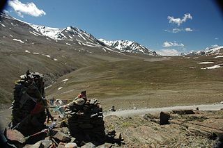
Bara-lacha la also known as Bara-lacha Pass, or Bārā Lācha La, is a high mountain pass in the Zanskar range of Northern-India, connecting Lahaul district in Himachal Pradesh to Leh district in Ladakh. Rail-cum-road tunnels are being constructed under the Bara-lacha la, at 4,750 metres (15,580 ft) high Lungalacha La and 5,184 metres (17,008 ft) high Taglang La to cater to the traffic on the existing NH3 Leh–Manali Highway and the under-construction Bhanupli–Leh line.

Pensi-la is a mountain pass in the Ladakh union territory of India, which is known as the Gateway to Zanskar. Pensi La is 4,400 metres (14,400 ft) above sea level and connects the Suru Valley region to the Zanskar Valley region. The summit at this end of the Suru Valley, the only peak which can be seen, is 7,012 metres (23,005 ft) high, while the mountain to the north is 6,873 metres (22,549 ft). The pass is about 25 km from Rangdum Monastery.

Tourism is one of the economic contributors to the union territory of Ladakh in Northern India. The union territory is sandwiched between the Karakoram mountain range to the north and the Himalayas to the south, and is situated at a height of 11,400 ft. Ladakh is composed of Leh and Kargil districts. The region contains prominent Buddhist sites and has an ecotourism industry.

The Zanskar River is the first major tributary of the Indus River, equal or greater in volume than the main river, which flows entirely within Ladakh, India. It originates northeast of the Great Himalayan range and drains both the Himalayas and the Zanskar Range within the region of Zanskar. It flows northeast to join the Indus River near Nimo.

Stok is a village in the Leh district of Ladakh, India. It is located in the Leh tehsil, in the Indus Valley 17 km southeast of the Leh town.

Stok Kangri is the highest mountain in the Stok Range of the Zazkar Mountains a Trans-Himalayan mountain in the Ladakh region of north India. The peak is located in Hemis National Park, 12 km southwest of the trailhead in the village of Stok and around 15 km southwest of the city of Leh, the capital of Ladakh.

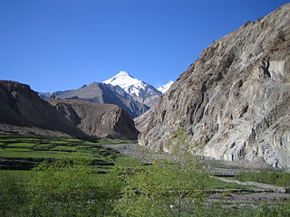
The Doda River or the Stod River is a river 79 kilometres (49 mi) long, which forms the Stod Valley in the Zanskar valley of the Leh district in the Union Territory of Ladakh in India.

Tsarap River, also known as Tsarap Chu, forms the eastern part of the Zanskar valley, in the Ladakh union territory of India. The 182 km (113 mi) long river is used for irrigation in riparian villages, and for adventure sports by tourists.
Skiu and Kaya are adjacent villages in the Markha River valley in Ladakh, India. The villages contain 11 and 12 households, respectively; the boundary between the villages is not clearly defined. They lie within the Hemis National Park.

Shey Monastery or Gompa and the Shey Palace complex are structures located on a hillock in Shey, 15 kilometres (9.3 mi) to the south of Leh in Ladakh, northern India on the Leh-Manali road. Shey was the summer capital of Ladakh in the past. It contains a huge Shakyamuni Buddha statue. It is the second largest Buddha statue in Ladakh.

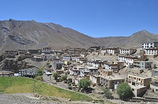
Sani Monastery, Sa-ni-[tshog], is located next to the village of Sani where the Stod Valley broadens into the central plain of Zanskar in Ladakh, northern India. It is about 6 km to the northwest of the regional centre of Padum, a gentle two-hour walk. Like Dzongkhul Monastery, it belongs to the Drukpa Kargyu school of Tibetan Buddhism, and is the only one of this order in Zanskar which has nuns. It is thought to be the oldest religious site in the whole region of Ladakh and Zanskar.
Kibber, also Kibber Khas and Khyipur, is a village high in the Spiti Valley in the Himalayas at 4,270 m (14,010 ft) in Himachal Pradesh in northern India. It contains a monastery and is a base for visiting the Kibber Wildlife Sanctuary. It is located 19 km (12 mi) from Kaza and a bus service connects them in the summer months. Agriculture forms the backbone of the local economy and lush green fields are abundant. It is the base for visitors to the Kibber Wildlife Sanctuary, home to about 30 snow leopards. Treks to nearby peaks and to a high pass in the Zanskar range between Spiti and Ladakh start from Kibber.
Kang Yatze or Kang Yatse is a mountain located at the end of the Markha valley in the Himalayas in the Ladakh region of northwest India. It is located in the Hemis National Park.
All Ladakh Gonpa Association (ALGA) is the central organisation of the Buddhist monasteries in Ladakh, India. It aims to preserve and strengthen the monastic institutions. It was founded by the 19th Kushok Bakula Rinpoche in 1949 and he acted as its president for 41 years, from 1949 until 1991. In 1949, the first meeting of the great monasteries was held and ten monasteries took part. All Ladakh Gonpa Association was registered in 1959 and is run by a governing body consisting of fifteen lama members belonging to all four major schools of Tibetan Buddhism. There are sixteen major monastic institutions with hundreds of monks in each monastery.

Nimmu–Padum–Darcha road or Zanskar Highway is a road between the Indian union territory of Ladakh and the state of Himachal Pradesh, passing through the region of Zanskar. It connects Nimmu in the Indus Valley to Padum, the capital of Zanskar, and to Darcha village in Lahul and Spiti. It provides an alternative to the Leh–Manali Highway in linking Ladakh with the rest of India. It was built by the Border Roads Organisation (BRO) of the Indian Army. The construction of road was completed in March 2024. The already completed Atal tunnel, and the proposed unidirectional-twin-tube total-4-lane Shingo La Tunnel, which is expected to be completed by 2025 will provide all weather connectivity and reduce the distance from Manali to Kargil by 522 km.

The culture of Ladakh refers to the traditional customs, belief systems, and political systems that are followed by Ladakhi people in India. The languages, religions, dance, music, architecture, food, and customs of the Ladakh region are similar to neighboring Tibet. Ladakhi is the traditional language of Ladakh. The popular dances in Ladakh include the khatok chenmo, cham, etc. The people of Ladakh also celebrate several festivals throughout the year, some of the most famous are Hemis Tsechu and Losar.

