Related Research Articles

The Jhelum River is a river in the northern Indian subcontinent. It originates at Verinag and flows through the Indian-administered territory of Jammu and Kashmir, into Pakistani-administered Azad Kashmir, then the Pakistani province of Punjab. It is the westernmost of the five rivers of the Punjab region, and flows through the Kashmir Valley. It is a tributary of the Chenab River and has a total length of about 725 kilometres (450 mi).

Kulgam, known as Kolgom in Kashmiri, is a town, an administrative division and capital of the Kulgam district in the Indian union territory of Jammu and Kashmir. It is located at a distance of 67 km (42 mi) from the summer state capital of Jammu and Kashmir, Srinagar. The city is divided into 16 electoral wards that has a population of 23,584, of which 12,605 are males while 10,979 are females.
Kulgam district is an administrative district of Indian-administered Jammu and Kashmir in the disputed Kashmir region. It is in the Kashmir division and is located at a distance of 18 kilometres (11 mi) towards south-west of Anantnag. The district comprises block, tehsil and town of Kulgam.
Kaprin is a village in the Shopian district of Jammu and Kashmir. The people of the village are very religious. Islam is the religion mostly followed. It has been a hub of education from many decades. The town is empowered with the modern day amenities like banking and other public establishments. People are associated with the business of Apple and other fruits. The area has produced many Engineers, doctors, Lawyers and people from all other walks of life.
Qaimoh is a block, a town and a notified area committee in Kulgam District in the union territory of Jammu and Kashmir, India. It is four miles to the west of Anantnag and six miles to the north of Kulgam District. It is 55 km to the south of Srinagar city. Qaimoh is one of the largest blocks in Jammu and Kashmir.
Hanji-Bough is a small village in Magam tehsil of district Budgam in Indian union territory of Jammu and Kashmir. According to Census 2011 the location code or village code of Hanji-Bough village is 000453. Hanji-Bough village falls in Magam Tehsil of Budgam district in Jammu & Kashmir, India. It is situated 10 km away from sub-district headquarter Beerwah and 25 km away from district headquarter Budgam. As per 2009 stats, Peth Kanihama is the gram panchayat of Hanji-Bough village.

The Sind River or the Sindh River is a river in the Ganderbal district of the union territory of Jammu and Kashmir, India. It is a major tributary of the Jhelum River and is 108 km (67 mi) long.
Chowgam is a mini town in Anantnag, now in the Kulgam district, with its block located in Qazigund of Anantnag district. It is located 8 km (5 mi) from its main district Kulgam, and 3 km (2 mi) from its block Qazigund and 9 km (6 mi) from district Anantnag. It is one of the oldest town's in Kashmir Valley. It's among the highly pada-likha mini town's of valley. Villages that depend on it are Churat, Sopat, Bonigam and many other minor villages.
Lar is a town and council district in the Ganderbal district of central Kashmir, in Jammu and Kashmir, India. It is a relatively newly established tehsil, carved out of the Ganderbal tehsil. It is situated 25 km from the heart of the summer capital, Srinagar, on National Highway between the foothills of the Himalayan mountains in the north and the picturesque Zabarwan Hills in the south. The Sind River, a major tributary to the Jehlum River flows through Lar. The famous Manasbal Lake lies a few kilometres away from the town centre.
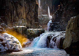
Aharbal is a hill station in the south-western part of Kashmir Valley in the Indian union territory of Jammu and Kashmir, south of the summer capital of Srinagar. Aharbal Waterfall is also known as Niagara Waterfall of Kashmir.
Kilam or (Kelam) is a village in Devsar Tehsil in the Kulgam district of Jammu and Kashmir. It is located 7 km (4.3 mi) north of the district headquarters, Kulgam and is 54 km (34 mi) from Srinagar, the summer capital of union territory of Jammu and Kashmir.

Kausar Nag or Kausarnag, is a high-altitude oligotrophic lake located at an elevation of 3,500 metres (11,500 ft) above sea level. Kausar Nag is located in the Pir Panjal mountain range in Kulgam district of Jammu and Kashmir. The lake is roughly 3 km (2 mi) long and .75 km (0 mi) at the widest point. The lake is the primary source of the Veshaw River, a tributary of Jhelum. This lake is considered sacred in Kashmir Shaivism.
Rambi Ara is a river and tributary to the River Jhelum located in Shopian District in the union territory of Jammu and Kashmir.
Nepora or Nipor is a village in Anantnag tehsil in Anantnag district in Jammu and Kashmir. This village lies between Anantnag and Kulgam districts and acts as a bordering village between two districts. The nearest railway station is Sadura railway station. A tributary of river Jehlum 'Sandran' flows through the village.
Yaripora or Yaripur is the second largest town by area and fourth least populous area of Kulgam district located in the union territory of Jammu and Kashmir in India. Its headquarters are located in Kulgam which is 12.8 km (8.0 mi) away from the main town of Yaripora. Most of its area is situated on the banks of rivulet Sonamann, a tributary of Veshaw that in turn joins the Jehlum at Sangam which comes under the Pir Panjal Range. Yaripora town has two electoral wards, with a population of 12,123, of which 6,043 are males and 6,080 are females, reported by the 2011 Census of India.
Frisal is a Tehsil and CD Block in district of Kulgam, Jammu and Kashmir, India. It is 14kms far from District Headquarter Kulgam and 6 Kms away from NH44 Bijbehara, situated on Bijbehara, Arwani-Frisal-Kulgam road. Its boundaries connect three districts of South kashmir. Frisal is 2nd largest town as per population in district Kulgam. The main source of income of this tehsil is agriculture, Horticulture, Business and Govt Jobs. There are many springs in town Frisal and is known as town of springs in district Kulgam. Frisal town is economically average and educationally well. Presently there are so many offices like Tehsil office, Block office,JK Bank, Punjab National Bank,social welfare office, Model Hospital(not functional yet) Govt. Degree college,one Higher secondary, 5 high Schools and several lower educational institutions.

The Government Degree College, Kelam is a co-education college located in Kelam, Kulgam in the Indian union territory of Jammu and Kashmir. The college was established in 2008 and is affiliated with Kashmir University. The college is recognized by University Grants Commission.
The Pohru River is a stream that flows through the Kupwara & Baramulla district of Kashmir region. It originates from Shamshabri mountains in the lolab valley Kupwara & passes through many villages where it finally enters into the jehum river near Doabgah sopore town Baramullah district Pohru River is one of the tributaries of the river Jehlum.
Chiranbal is a tourist attraction, a meadow and a hiking destination in the Kulgam district of Jammu and Kashmir, India. It is situated at a distance of 43 km from Aharbal and 75 km from Srinagar.

Zeipora is a village located in Devsar tehsil of Kulgam district in Jammu and Kashmir, India. It is situated 6 kilometres (3.7 mi) away from sub-district headquarter Devsar and 8 kilometres (5.0 mi) away from district headquarter Kulgam.
References
- ↑ "Home". kulgam.gov.in.
- ↑ "Google Maps". Google Maps. Retrieved 29 January 2021.
- ↑ Service, Tribune News. "13 houses washed away in Kulgam flash floods". Tribuneindia News Service. Retrieved 28 December 2020.
| Passes |  | |
|---|---|---|
| Valleys | ||
| Cities | ||
| Towns |
| |
| Rivers | ||
| Glaciers | ||
| Lakes | ||
| Mountains | ||
| Hill stations and Mughal gardens | ||
| Protected Areas | ||
| See also | ||