Tangmarg

Last updated

Tangmarg
Town
Tangmarg.jpg
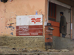
Tangmarg Post Office
India Jammu and Kashmir Union Territory location map.svg
Red pog.svg
Tangmarg
Location in Jammu and Kashmir, India
India location map.svg
Red pog.svg
Tangmarg
Tangmarg (India)
Coordinates: 34°03′33″N74°25′28″E / 34.05917°N 74.42444°E / 34.05917; 74.42444
CountryFlag of India.svg  India
Union territory Jammu and Kashmir
District Baramulla
Languages
  Official Kashmiri, Urdu, Hindi, Dogri, English [1] [2]
  Spoken Pahadi, Gujari
Time zone UTC+5:30 (IST)
PIN
193402
Telephone code+911954

Tangmarg is a town and tehsil in Baramulla district in Indian union territory of Jammu and Kashmir. In 2014, Tangmarg was granted a sub division and trifurcated into three Tehsils (Tangmarg, Kunzer and Karhama), with Sub Divisional Magistrate SDM Office located at Tangmarg. The Tangmarg town is central to more than 100 villages in the vicinity. Tangmarg is gateway of gulmarg which is just 13kms away, also drung waterfall is 3kms away which makes tangmarg most crowded place in the evening due to clean & fresh environment.

Contents

Tangmarg has a post office that has been recently modernized, computerized and renovated and there are plans to develop it into a model post office at par with project arrow post offices. There are many hotels and restaurants, everything required by travelling tourists. Tangmarg is 39 km (24 mi) from Srinagar by a two-lane road. Tangmarg has many tourist spots like Drung, Gulmarg, Baderkoot, Zandpal, Gogaldara, Nigli Nullah and Baba Reshi. The name "Baba Reshi" is locally given for the great Sufi saint of Kashmir Baba Payam ud Din Reshi who has a Shrine located around 6 km (3.7 mi) from Tangmarg. Tangmarg is also known as gate of Gulmarg. Tangmarg is also known as shen kaul which means brook of snow. Tangmarg is also famous for trout fish.

Geography

The Longitude is 75.36679 and the Latitude is 33.80405. [3] Amongst the prominent villages of this tehsil are Hardushoora, Ferozpora, Pariswani, Chaindil Waingam, Kulhama, Hajibal, Bungam, Reram, Druroo, Hardu Ichloo, Khaipora, Solinda Kunzer, Devbugh, Kralweth Lalpora, Gonipora, Devpora Dardpora, Ganibaba, Pandithpora Bala, Baderkoot, Ratnipora, Ogmuna, Hardu-Aboora, Hariwatnoo, Treran, Katibugh, Chandilora, Qazipora, Gund Dalwash, Tarahama. Tangmarg is famous for fresh cold water, heavy snowfall, and tourism. Tangmarg is a hilly area with most parts covered by lush green forests.

Access and transport

Tangmarg is located about 38 km (24 mi) from Srinagar; the journey time by road is about 40 minutes. [4] Sheikh ul-Alam International Airport, Srinagar is 49 km (30 mi) away. [4] Gulmarg is 13 km (8.1 mi) away on the Narbal-Tangmarg Road. [4] The general approach to the town is through road transport (taxi and bus). Transport is available from Srinagar, Baramulla, Magam, Sopore, Gulmarg and Pattan. The town is also not far from the Mazhama Railway station.[ citation needed ]

A road from Tangmarg to Gogaldara is under construction. This road would connect Tehsil Tangmarg with Tehsil Khag of Badgam district.[ citation needed ] Another road from Drung to Poonch district of Pir Panjal region is under consideration by the government.[ citation needed ]

History

The history of Tangmarg dates back to Mughal Era. It was used as a gateway to Gulmarg. Literally from local dialect Tang means Pear and Marg means meadow. There are many pear, cherry and apple trees in the vicinity of Tangmarg town scattered in different villages. The Town witnessed killings of Civilians in 2010 by Forces

Education and health

A Sub-district Hospital is located at Tangmarg with affiliated Primary Health Centres in all major villages. A Government Degree College was established in 2011-12 at Chandilora. 5 Higher Secondary Schools are situated in Tangmarg including Tyndale Biscoe and Mallinson School and Fazil Kashmiri memorial higher secondary School.

Language

Kashmiri is the predominant language spoken in the villages of Tangmarg. Urdu is second widely spoken language after Kashmiri. Pahari is another important language spoken in area whereas English language is also spoken by educated class and those who deal with the tourism industry. Gojri also has many speakers.

Related Research Articles

<span class="mw-page-title-main">Baramulla district</span> District in Jammu and kashmir, India

Baramulla district or Varmul is one of the 20 districts in the Indian-administered union territory of Jammu and Kashmir in the disputed Kashmir region. Baramulla town is the administrative headquarters of this district. The district covered an area of 4,588 km2 (1,771 sq mi) in 2001, but it was reduced to 4,243 km2 (1,638 sq mi) at the time of 2011 census. In 2016, the district administration said that the area was 4,190 km2 (1,620 sq mi). Muslims constitute about 98% of the population.

<span class="mw-page-title-main">Gulmarg</span> Hill Station in Jammu & Kashmir, India

Gulmarg, known as Gulmarag in Kashmiri, is a town, hill station, popular tourist destination, popular skiing destination and a notified area committee in the Baramulla district in the Indian union territory of Jammu and Kashmir. It is located at a distance of 31 km (19 mi) from Baramulla and 49 km (30 mi) from Srinagar. The town is situated in the Pir Panjal Range in the Western Himalayas and lies within the boundaries of Gulmarg Wildlife Sanctuary.

<span class="mw-page-title-main">Baramulla</span> District in Jammu & Kashmir, India

Baramulla, also known as Varmul in Kashmiri, is a City and municipality of the Baramulla district of the Indian-administered Jammu and Kashmir in the disputed Kashmir region. It is also the administrative headquarters of the Baramulla district, located on the banks of the River Jhelum downstream from Srinagar, the summer capital of Jammu and Kashmir. The town was earlier known as gateway of Kashmir, serving as the major distribution centre for goods arriving in Kashmir valley through the Jhelum valley cart road.

Kunzar, or Kunzer, is a town in the union territory of Jammu and Kashmir located in the District Baramulla. It is 30 km from Srinagar and approximately 32 km from Baramulla town.

Magam is a tehsil in central Kashmir's Beerwah sub-district. It is also a town, notified area committee, and a block in Budgam district in the Indian administered union territory of Jammu and Kashmir. It is 11 km (6.8 mi) away from sub-district headquarter Beerwah and 20 km (12 mi) away from Srinagar, the summer capital of Jammu and Kashmir. Magam is the top business hub in this locality, located on the way to Gulmarg. Magam comes both in baramulla district and budgam which makes this famous across these districts for business. The Idara Abu Fazal Abbas Islamic Library, opened in Magam in 1985, is the largest Islamic private library in Jammu and Kashmir.

<span class="mw-page-title-main">Beerwah, Jammu and Kashmir</span> Town in Jammu and Kashmir, India

Beerwah also pronounced as Beeru is a subdistrict, tourist destination and one of the oldest towns of Jammu and Kashmir and a municipal committee in Budgam district in the Indian administered union territory of Jammu and Kashmir. It is also one of the oldest tehsils of Jammu and Kashmir with one of the largest towns in Budgam district. Beerwah is 27 km (17 mi) away from the summer capital Srinagar via Bemina, 31 km (19 mi) via Magam, 33 km (21 mi) via Soibugh and 35 km (22 mi) via Budgam. Beerwah subdistrict has 4 tehsils namely Beerwah, Magam, Narbal and Khag. Beerwah is located along the banks of River Sukhnaag.

<span class="mw-page-title-main">Tourism in Jammu and Kashmir</span> Tourist places in Jammu and Kashmir

Jammu and Kashmir is home to several valleys such as the Kashmir Valley, Chenab Valley, Sindh Valley and Lidder Valley. Some major tourist attractions in Jammu and Kashmir are Srinagar, with its renowned Dal Lake and Mughal Gardens, Gulmarg, Pahalgam, Bhaderwah, Patnitop and Jammu. Every year, thousands of Hindu pilgrims visit holy shrines of Vaishno Devi and Amarnath which has had a significant impact on the state's economy.

<span class="mw-page-title-main">Munawar Abad</span> Town in Jammu and Kashmir, India

Munawar Abad, locally known as Muniwar (Munawarabad), is a town located in heart of Srinagar in the Indian union territory of Jammu and Kashmir. It is 2 km from Lal Chowk. Munawar Abad is the main link between downtown Srinagar and central Srinagar.

Hardu-Aboora is a locality in Karhama tehsil in Baramulla district in the Indian union territory of Jammu and Kashmir. It is situated on the banks of Ferozpora Nallah, at the foothills of the mountain range that runs parallel to the Srinagar-Gulmarg highway on its left side, some 15 km (9.3 mi) from Tangmarg town, Baramulla and 29 km (18 mi) from the state capital, Srinagar, and 10 km (6.2 mi) from railway station Mazhama. Under new Administrative units, Hardu Aboora was granted CD Block status, under the jurisdiction of newly carved tehsil, Karhama.

Ogmuna is a village know as oldest village of the tehsil Tangmarg in the Baramulla district of Indian union territory of Jammu and Kashmir

Durhama is a small village in Baramulla district in the Indian union territory of Jammu and Kashmir. It is about 20 km from district headquarters Baramulla, 13 km from the apple town Sopore and 50 km from Batmaloo, Srinagar via Putukhah- Wagoora road and 44 km via Tapper-Kreeri road. It is about 100m away from the Tehsil headquarter Wagoora and about 3.5 km from the medical block Kreeri. It is situated on the left side of the link road which connects Baramulla and Babareshi-Gulmarg. The village has three mosques and 95 households. The population of Durhama is about 698. There is a primary and a middle school in the outskirts of the village. The literacy rate of Durhama is about 67.37% as per 2011 census. A building of the block development office Wagoora is located at the entrance of Durhama. A medical sub centre is also located alongside B.D.O. office.

Hanjiwera is a notified area and village in Singhpora, Pattan, Baramulla district in Indian union territory of Jammu and Kashmir. It is located 31 km (19 mi) to the east from the district headquarters in Baramulla and 23 km (14 mi) from union territory capital, Srinagar.

Pattan is a sub-district, town and a municipal committee in Baramulla district in the Indian union territory of Jammu and Kashmir.

<span class="mw-page-title-main">Khag, Jammu and Kashmir</span> Tehsil in Jammu and Kashmir, India

Khag is a tehsil in and block in the Beerwah sub-district of the Budgam district in the Indian union territory of Jammu and Kashmir. It is 8.8 km (5.5 mi) away from sub-district headquarter Beerwah and 35 km (22 mi) away from Srinagar, the summer capital of Jammu and Kashmir.

<span class="mw-page-title-main">Baba Payam ud Din Reshi</span> Forest Area in Jammu and Kashmir, India

Babareshi is the name of a village, forest area, tourist and religious place in Jammu and Kashmir, India. It is named after the Sufi saint Baba Payam uddin Reshi.

<span class="mw-page-title-main">Purni Suder Shah</span> Village in Jammu and Kashmir, India

Purni Suder Shah, also known as The Dwelling Place Of Sufi Saint Suder Shah, is a village in the Budgam district in the Indian union territory of Jammu and Kashmir. It lies in the Narbal tehsil of district Budgam, on the eastern side of Mazhom railway station. It is a small village and only a few generations have lived here. It is recognised for its vegetation and agriculture.

<span class="mw-page-title-main">Hathlangoo</span> Village in Jammu & Kashmir, India

Hathlangoo previously known as Hashmatpora is a village in the Sopore tehsil of Baramulla district, in the Indian union territory of Jammu and Kashmir. It is located 8 km (5.0 mi) away from sub-district headquarter Sopore and 22 km (14 mi) away from district headquarters Baramulla. It is one of the largest villages in Zaingair. The Hathlangoo village has Janwara Village in the South, Magraypora in the North, Botingoo in the Northwest, Malmapanpora in the West and Wular Lake in the East.

Waripora Bangil is a village located in the town of Kunzer in the Baramulla district of the Indian-administered union territory of Jammu and Kashmir. It is situated 40 kilometres (25 mi) east of the district headquarters of Baramulla and 20 kilometres (12 mi) west of the capital city of Srinagar.

Narbal is a tehsil in central Kashmir's Beerwah sub-district. It is also a block in Budgam district in the Indian administered union territory of Jammu and Kashmir. It is 18 km (11 mi) away from sub-district headquarter Beerwah and 13 km (8.1 mi) away from Srinagar, the summer capital of Jammu and Kashmir.

Manglora, also spelled Monglora or Monglara, is a village on the Narbal-Tangmarg road in the Baramulla district of the union territory of Jammu and Kashmir. It comes under tehsil Kunzer.

References

  1. "The Jammu and Kashmir Official Languages Act, 2020" (PDF). The Gazette of India. 27 September 2020. Retrieved 27 September 2020.
  2. "Parliament passes JK Official Languages Bill, 2020". Rising Kashmir. 23 September 2020. Retrieved 23 September 2020.
  3. https://indiamapia.com  › Baramulla Tangmarg Pin Code, Tangmarg, Baramulla Map, Latitude and ...
  4. 1 2 3 Mohindra, Vandana (18 July 2017). "Tangmarg: Strawberries and Green". Outlook (Indian magazine) . Retrieved 19 March 2021.